Kentucky (rzeka)
 | |
| Państwo | |
|---|---|
| Rzeka | |
| Długość | 417 km |
| Źródło | |
| Miejsce | North Fork Kentucky River↗, South Fork Kentucky River↗ |
| Współrzędne | |
| Ujście | |
| Miejsce | Ohio |
| Współrzędne | |
| Mapa | |
 | |
Kentucky – rzeka w stanie Kentucky, lewy dopływ Ohio. Liczy 417 km długości[1]. Powstaje koło Beattyville z połączenia trzech rzek źródłowych, mających swe źródła na wyżynie Cumberland. Głównym miastem nad Kentucky jest Frankfort[2]. Wpływa do Ohio 19,3 km od Madison[3].
Przepływ rzeki w okolicach różnych miejscowości[4]:
- Willow - 52,95 m³/s
- Winchester - 72,49 m³/s
- Tyrone - 88,63 m³/s
Przypisy
- ↑ Kentucky River, [w:] Encyclopædia Britannica [online] [dostęp 2014-04-21] (ang.).
- ↑ praca zbiorowa: Encyklopedia Powszechna PWN. T. 2. G-M. Warszawa: Państwowe Wydawnictwo Naukowe, 1974, s. 454.
- ↑ Kentucky (river). W: Collier's New Encyclopedia. P. F. Collier & Son Company, 1921.
- ↑ Current Conditions for Kentucky: Streamflow -- 208 site(s) found. USGS. [dostęp 2014-04-21].
Media użyte na tej stronie
The flag of Navassa Island is simply the United States flag. It does not have a "local" flag or "unofficial" flag; it is an uninhabited island. The version with a profile view was based on Flags of the World and as a fictional design has no status warranting a place on any Wiki. It was made up by a random person with no connection to the island, it has never flown on the island, and it has never received any sort of recognition or validation by any authority. The person quoted on that page has no authority to bestow a flag, "unofficial" or otherwise, on the island.
Autor: Pfly, Licencja: CC BY-SA 2.5
This is a map of the Kentucky River watershed, showing the North Fork, Middle Fork, and South Fork tributaries. I, Pfly, made it, based on USGS data.
Autor: Schwaltz, Licencja: CC BY-SA 3.0
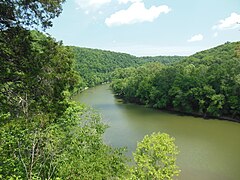
View from Kentucky River overlook in Raven Run Nature Sanctuary
Autor: Uwe Dedering, Licencja: CC BY-SA 3.0
Relief location map of the USA (without Hawaii and Alaska).
EquiDistantConicProjection : Central parallel :
* N: 37.0° N
Central meridian :
* E: 96.0° W
Standard parallels:
* 1: 32.0° N
* 2: 42.0° N
Made with Natural Earth. Free vector and raster map data @ naturalearthdata.com.
Formulas for x and y:
x = 50.0 + 124.03149777329222 * ((1.9694462586094064-({{{2}}}* pi / 180))
      * sin(0.6010514667026994 * ({{{3}}} + 96) * pi / 180))
y = 50.0 + 1.6155950752393982 * 124.03149777329222 * 0.02613325650382181
      - 1.6155950752393982  * 124.03149777329222 *
     (1.3236744353715044  - (1.9694462586094064-({{{2}}}* pi / 180))
      * cos(0.6010514667026994 * ({{{3}}} + 96) * pi / 180))


