Keswick (Kumbria)
| ||
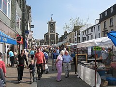
(c) Paul Anderson, CC BY-SA 2.0 | ||
| Państwo | ||
| Kraj | ||
| Hrabstwo | Kumbria | |
| Dystrykt | Allerdale | |
| Populacja (2011) • liczba ludności | 4821 | |
| Nr kierunkowy | 017687 | |
| Kod pocztowy | CA12 | |
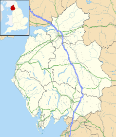
Położenie na mapie Kumbrii Contains Ordnance Survey data © Crown copyright and database right, CC BY-SA 3.0 | ||
Położenie na mapie Wielkiej Brytanii (c) Karte: NordNordWest, Lizenz: Creative Commons by-sa-3.0 de | ||
| Portal | ||
Keswick – miasto i civil parish w Anglii, w Kumbrii, w dystrykcie Allerdale[1]. Leży nad jeziorem Derwent Water, 35 km na południe od miasta Carlisle i 398 km na północny zachód od Londynu[2]. W 2011 roku civil parish liczyła 4821 mieszkańców[3].
Od 1875 organizuje się tutaj corocznie "konwencje" (ang. Keswick conventions) zwolenników ruchu uświęceniowego, służące rozwojowi jednej z odmian pobożności ewangelikalnej[4].
W mieście znajduje się muzeum ołówków Cumberland Pencil Museum[5].
Przypisy
- ↑ Ordnance Survey linked data
- ↑ Keswick na mapie (ang.). getamap.ordnancesurvey.co.uk. [dostęp 2010-11-27].
- ↑ Neighbourhood Statistics. [dostęp 2015-11-30]. [zarchiwizowane z tego adresu (2015-12-09)].
- ↑ Keswick Convention, [w:] The Oxford Dictionary of the Christian Church, red. F.L. Cross, E.A Livingstone, Oxford – New York 1990 ISBN 0-19-211545-6 s. 778.
- ↑ The UK's oddest days out (ang.). BBC News, 2013-09-14. [dostęp 2013-09-15].
Linki zewnętrzne
Witryna organizatora Keswick Convention (dostęp: 2-10-2014).
Media użyte na tej stronie
(c) Karte: NordNordWest, Lizenz: Creative Commons by-sa-3.0 de
Location map of the United Kingdom
Flag of England. Saint George's cross (a red cross on a white background), used as the Flag of England, the Italian city of Genoa and various other places.
Autor: Diliff, Licencja: CC BY-SA 3.0
A 2 x 16 segment panorama of Keswick, Cumbria, England, as viewed from Latrigg north of the town.
Contains Ordnance Survey data © Crown copyright and database right, CC BY-SA 3.0
Map of Cumbria, UK with the following information shown:
- Administrative borders
- Coastline, lakes and rivers
- Roads and railways
- Urban areas
Equirectangular map projection on WGS 84 datum, with N/S stretched 170%
Geographic limits:
- West: 3.80W
- East: 2.10W
- North: 55.20N
- South: 54.02N
(c) Paul Anderson, CC BY-SA 2.0
Market Day Keswick Market day in Keswick is Thursday and Saturday and the Market Square is now fully pedestrianised.
Its origins as a market town date back to 1276 when Edward I granted Thomas, Lord of the Manor of Derwentwater a charter to hold a Saturday market, which still continues today over 700 years later. The building with the tower is The Moot Hall now the home of the Tourist Information Centre, which has been used in the past as a covered market, a courthouse, a museum and a prison.
For more information about Keswick click on http://www.keswick.org/keswick.asp


