Khokana
| gaun wikas samiti | |
 | |
| Państwo | |
|---|---|
| Strefa | |
| Dystrykt | Lalitpur |
| Populacja (2001) • liczba ludności |
|
Położenie na mapie Nepalu  (c) Karte: NordNordWest, Lizenz: Creative Commons by-sa-3.0 de | |
Khokana – gaun wikas samiti w środkowej części Nepalu w strefie Bagmati w dystrykcie Lalitpur[1]. Według nepalskiego spisu powszechnego z 2001 roku liczył on 818 gospodarstw domowych i 4542 mieszkańców (2296 kobiet i 2246 mężczyzn)[2].
- Khokana


Przypisy
- ↑ Index of Geographical names of Nepal - Central Development Region - Volume II. National Geographic Information Infrastructure Programme. [dostęp 2010-09-27]. (ang.).
- ↑ VDC’s population. National Association of Village Development Committees in Nepal (NAVIN). [dostęp 2020-10-12]. (ang.).
- Stolica dystryktu: Patan
Media użyte na tej stronie
Nepal adm location map.svg
(c) Karte: NordNordWest, Lizenz: Creative Commons by-sa-3.0 de
Location map of Nepal including the 7 provinces
(c) Karte: NordNordWest, Lizenz: Creative Commons by-sa-3.0 de
Location map of Nepal including the 7 provinces


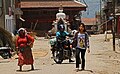
Khokana-46-Getreidetransport unterm Schirm-2014-gje.jpg
Autor: Gerd Eichmann, Licencja: CC BY-SA 4.0
People of Khokana in Nepal
Autor: Gerd Eichmann, Licencja: CC BY-SA 4.0
People of Khokana in Nepal

Khokana-42-Getreide zum Trocknen-2014-gje.jpg
Autor: Gerd Eichmann, Licencja: CC BY-SA 4.0
Khokana in Nepal
Autor: Gerd Eichmann, Licencja: CC BY-SA 4.0
Khokana in Nepal

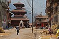
Khokana-Rudrayani-Tempel-04-2014-gje.jpg
Autor: Gerd Eichmann, Licencja: CC BY-SA 4.0
Hindu temple in Khokana in Nepal
Autor: Gerd Eichmann, Licencja: CC BY-SA 4.0
Hindu temple in Khokana in Nepal

Khokana-Rudrayani-Tempel-10-Menschen-2014-gje.jpg
Autor: Gerd Eichmann, Licencja: CC BY-SA 4.0
Hindu temple in Khokana in Nepal
Autor: Gerd Eichmann, Licencja: CC BY-SA 4.0
Hindu temple in Khokana in Nepal

Khokana-56-zwei alte Frauen-2014-gje.jpg
Autor: Gerd Eichmann, Licencja: CC BY-SA 4.0
People of Khokana in Nepal
Autor: Gerd Eichmann, Licencja: CC BY-SA 4.0
People of Khokana in Nepal
Dyo Pukhu 01.jpg
Autor: Krish Dulal, Licencja: CC BY-SA 3.0
A festival celebrated in Khokana, Kathmandu
Autor: Krish Dulal, Licencja: CC BY-SA 3.0
A festival celebrated in Khokana, Kathmandu