Killington (Vermont)
| |||
 | |||
| |||
| Państwo | |||
| Stan | |||
| Wysokość | 561 m n.p.m. | ||
| Populacja (2010) • liczba ludności | 811 | ||
| Kod pocztowy | 05751 | ||
Położenie na mapie Vermontu  | |||
Położenie na mapie Stanów Zjednoczonych  | |||
| Strona internetowa | |||
| Portal | |||
Killington – amerykańska miejscowość położona w hrabstwie Rutland, w stanie Vermont. W 2010 roku miejscowość liczyła 811 mieszkańców. Miejscowość ta, położona w Górach Zielonych jest ośrodkiem narciarskim, najważniejsze szczyty to Killington Peak (1289 m) i Pico Peak (1209 m). Ośrodek Killington Ski Resort posiada łącznie 117 km tras narciarskich, z czego 28% przeznaczone jest dla początkujących, 33% dla średnio-zaawansowanych, a 39% jako zaawansowanych. Trasy obsługiwane są przez system 21 wyciągów, w tym dwie kolejki gondolowe[1]. Ośrodek otwarto w 1958 roku[2]. Znajduje się tu też sieć pieszych szlaków turystycznych oraz trasy rowerowe.
W listopadzie 2016 roku odbyły się tu po raz pierwszy zawody Pucharu Świata w narciarstwie alpejskim.
Galeria

Widok ze szczytu Killington Peak
Trasa narciarska

Trasa Outer Limits

Widok na ośrodek ze Skye Peak

Bear Mountain
Przypisy
Linki zewnętrzne
Media użyte na tej stronie
Autor: Uwe Dedering, Licencja: CC BY-SA 3.0
Location map of the USA (without Hawaii and Alaska).
EquiDistantConicProjection:
Central parallel:
* N: 37.0° N
Central meridian:
* E: 96.0° W
Standard parallels:
* 1: 32.0° N
* 2: 42.0° N
Made with Natural Earth. Free vector and raster map data @ naturalearthdata.com.
Formulas for x and y:
x = 50.0 + 124.03149777329222 * ((1.9694462586094064-({{{2}}}* pi / 180))
      * sin(0.6010514667026994 * ({{{3}}} + 96) * pi / 180))
y = 50.0 + 1.6155950752393982 * 124.03149777329222 * 0.02613325650382181
      - 1.6155950752393982  * 124.03149777329222 *
     (1.3236744353715044  - (1.9694462586094064-({{{2}}}* pi / 180))
      * cos(0.6010514667026994 * ({{{3}}} + 96) * pi / 180))

The flag of Navassa Island is simply the United States flag. It does not have a "local" flag or "unofficial" flag; it is an uninhabited island. The version with a profile view was based on Flags of the World and as a fictional design has no status warranting a place on any Wiki. It was made up by a random person with no connection to the island, it has never flown on the island, and it has never received any sort of recognition or validation by any authority. The person quoted on that page has no authority to bestow a flag, "unofficial" or otherwise, on the island.
Autor: Royalbroil, Licencja: CC BY-SA 4.0
Downtown Killington, VT on US Route 4.

Autor: NHRHS2010, Licencja: CC-BY-SA-3.0
Bear Mountain in Killington Ski Resort, Vermont
Autor: Alexrk, Licencja: CC BY 3.0
Ta mapa została stworzona za pomocą GeoTools.

Autor: Briancua, Licencja: CC BY-SA 4.0
View from the peak of Mount Killington, as seen after hiking up beyond Catwalk

Autor: NHRHS2010, Licencja: CC-BY-SA-3.0
View of Snowshed Base, Killington Grand Hotel, and other hotels/condos along the East Mountain Road, from Skye Peak in Killington Ski Resort

Autor: NHRHS2010, Licencja: CC-BY-SA-3.0
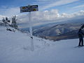
Trail signs at Killington that leads people to the two double black diamond trails, Outer Limits and Devil's Fiddle, the two steepest trails in Killington.

Autor: town of Killington, Licencja: CC BY-SA 3.0
Logo of Killington Vermont to be used in the Killington, VT wiki entry

Autor: NHRHS2010, Licencja: CC-BY-SA-3.0
View of Bear Mountain Base in Killington Ski Resort from the top of the double black diamond trail, Outer Limits, which is the steepest mogul run in New England. Picture taken by User:NHRHS2010.