Kingston
 Devon House – przykład XIX-w. rezydencji w Kingston | |
| Państwo | |
|---|---|
| Hrabstwo | |
| Gmina | |
| Burmistrz | Angela Brown Burke[1] |
| Powierzchnia | 453 km² |
| Wysokość | 9 m n.p.m. |
| Populacja (2012) • liczba ludności • gęstość |
|
Położenie na mapie Jamajki  | |
| Strona internetowa | |


Kingston – stolica i największe miasto Jamajki położona w jej południowej części nad Morzem Karaibskim.
Położenie
Miasto leży na południowym wybrzeżu Jamajki nad zatoką Kingston, otoczone jest przez pasmo Gór Błękitnych. Znajduje się w hrabstwie Surrey, na terenie regionów Kingston oraz częściowo Saint Andrew.
W pobliżu miasta położony jest Port lotniczy Kingston-Norman Manley.
Przedmieścia Kingston to m.in. dzielnica slumsów Trenchtown.
Gospodarka
Ważny port morski i międzynarodowy port lotniczy. Miasto jest też najważniejszym ośrodkiem przemysłowym wyspy (przemysł paliwowy, cementowy, chemiczny, maszynowy oraz metalowy)[3].
Historia
Miasto zostało założone przez Anglików w 1693 w pobliżu zniszczonej przez trzęsienie ziemi z 1692 dotychczasowej stolicy – Port Royal. Kingston stało się stolicą w 1872 (poprzednio było nią Spanish Town). We wrześniu 2004 miasto nawiedził huragan Ivan, który spowodował duże zniszczenia.
Sport
W 1966 odbyły się w Kingston igrzyska Imperium Brytyjskiego i Wspólnoty Brytyjskiej[4]. Głównie pod kątem tej imprezy wybudowano kompleks sportowy Independence Park. W 2002 miasto gościło lekkoatletyczne mistrzostwa świata juniorów[5].
Religia
Kingston jest siedzibą metropolii oraz archidiecezji kościoła katolickiego[6]. Główną katolicką świątynią wyspy jest katedra Świętej Trójcy w Kingston.
Transport
W latach 1876–1948 działał w mieście system komunikacji tramwajowej
Miasta partnerskie
Zobacz też
Galeria

Budynek w Downtown, siedziba Bank of Jamaica

Kingston w 1907 roku
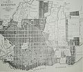
Mapa Kingston z 1897 roku
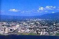
Kingston od strony zatoki
Przypisy
- ↑ Mayors. localgovjamaica.gov.jm. [dostęp 2015-10-21]. [zarchiwizowane z tego adresu (21 lutego 2012)]. (ang.).
- ↑ Population by Parish. Statistical Institute of Jamaica (Urząd Statystyczny Jamajki). [dostęp 2015-09-22]. (ang.).
- ↑ Kingston, [w:] Encyklopedia PWN [online] [dostęp 2021-07-17].
- ↑ 1966 British Empire and Commonwealth Games. thecgf.com. [dostęp 2015-10-21]. [zarchiwizowane z tego adresu (19 sierpnia 2017)]. (ang.).
- ↑ IAAF World Junior Championships, gbrathletics [dostęp 2015-10-21] (ang.).
- ↑ David M. Cheney: Archdiocese of Kingston in Jamaica. catholic-hierarchy.org, 25 stycznia 2015. [dostęp 2015-10-21]. (ang.).
Bibliografia
- Kingston, [w:] Encyclopædia Britannica [online] [dostęp 2015-10-21] (ang.).
Media użyte na tej stronie

Flag of Jamaica. “The sunshine, the land is green, and the people are strong and bold” is the symbolism of the colours of the flag. GOLD represents the natural wealth and beauty of sunlight; GREEN represents hope and agricultural resources; BLACK represents the strength and creativity of the people. The original symbolism, however, was "Hardships there are, but the land is green, and the sun shineth", where BLACK represented the hardships being faced.


The flag of Navassa Island is simply the United States flag. It does not have a "local" flag or "unofficial" flag; it is an uninhabited island. The version with a profile view was based on Flags of the World and as a fictional design has no status warranting a place on any Wiki. It was made up by a random person with no connection to the island, it has never flown on the island, and it has never received any sort of recognition or validation by any authority. The person quoted on that page has no authority to bestow a flag, "unofficial" or otherwise, on the island.

map of Kingston Jamaica in the 1890s

Autor: Anatoly Terentiev, Licencja: CC-BY-SA-3.0
Downtown Kingston waterfront
.jpg)
Bird's eye view of Kingston in 1907
Astronaut Photo of Kingston, Jamaica taken from the International Space Station (ISS) during Expedition 22 on January 22, 2010.
The ruins of the 1882 fire that swept through the lower half of Kingston, Jamaica.
The pictures are numbered, but they're numbered slightly oddly, so the following description also gives the location of each picture, as well as a little extra information for those not viewing at full size.
Top row: Left (2), the view from the Royal Mail Steam-Ship Company's Wharf. Centre (1), Peter-lane, from Barry-street, looking south. Right (3), In Harbour Street.
Second Row: Left (4), German Synagoue, Orange-street. Note the lack of roof. Right (5), Harbour-street from King-street.
Third row: Left (7), Ruins from McDonald's Wharf, King-street. Centre (6), Portuguese Synagogue, from Princess-street. Take a close look, especially at the left side, near the burned tree: The whole back of it is destroyed. Right (8), Water-lane, from King-street. The sign on the left building advertises Christmas Cards and Toys, in the somewhat blunt Victorian fashion.
Bottom Row: Left (9), Princess-street, from Port Royal-street, looking north. Note the sky visible through the windows. Right (10), Peter-lane, from Town-street.
To allow this to be printed, the image file must be somewhat large. See links for this image shrunk to dimensions chosen for ease of computer viewing.

Photo of the city of Kingston taken from a Jamaica Defence Force helicopter flying into the mainland from sea and further edited to achieve an appropriate size