Kingston upon Hull
| |||
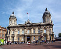
(c) David Wright, CC BY-SA 2.0 Maritime Museum w Kingston upon Hull | |||
| |||
| Państwo | |||
| Kraj | |||
| Region | Yorkshire and the Humber | ||
| Hrabstwo | East Riding of Yorkshire | ||
| Powierzchnia | 71 km² | ||
| Populacja (2016) • liczba ludności • gęstość | 260 240[1] 3665 os./km² | ||
| Nr kierunkowy | 01482 | ||
| Kod pocztowy | HU | ||
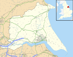
Położenie na mapie East Riding of Yorkshire Contains Ordnance Survey data © Crown copyright and database right, CC BY-SA 3.0 | |||
Położenie na mapie Wielkiej Brytanii (c) Karte: NordNordWest, Lizenz: Creative Commons by-sa-3.0 de | |||
| Strona internetowa | |||
| Portal | |||
Kingston upon Hull (potocznie Hull) – miasto w Wielkiej Brytanii (Anglia), w hrabstwie ceremonialnym East Riding of Yorkshire, nad estuarium Humber i jego dopływem Hull, typowo przemysłowe (stocznie, rafinerie, fabryka czekolady).
Było największym miastem zlikwidowanego hrabstwa Humberside. Obecnie jest samodzielną jednolitą jednostką administracyjną (unitary authority), wchodzącą w skład regionu Yorkshire and the Humber.
W mieście jest most obrotowy, który stał się lokalną atrakcją i przyczynił się do rewitalizacji zaniedbanej, poprzemysłowej dzielnicy na lewym brzegu rzeki Hull[2].
W kulturze
Hull jako jedyne miasto w Anglii ma budki telefoniczne w kolorze kremowym (a nie czerwonym, jak pozostałe)[3].

Miasta partnerskie
 Freetown, Sierra Leone
 Niigata, Japonia
 Raleigh, Stany Zjednoczone
 Reykjavík, Islandia
 Rotterdam, Holandia
 Szczecin, Polska
Przypisy
- ↑ Population Estimates for UK, England and Wales, Scotland and Northern Ireland – Office for National Statistics, www.ons.gov.uk [dostęp 2017-10-22] (ang.).
- ↑ Kingston upon Hull: grający most. Bryla.pl, 2017-01-20. [dostęp 2017-01-20].
- ↑ Why Hull has cream phone boxes (and why it’s relevant to tech today) (ang.). NS Tech, 2016-08-25. [dostęp 2017-01-15].
Media użyte na tej stronie
(c) Karte: NordNordWest, Lizenz: Creative Commons by-sa-3.0 de
Location map of the United Kingdom
Flag of England. Saint George's cross (a red cross on a white background), used as the Flag of England, the Italian city of Genoa and various other places.
The flag of Navassa Island is simply the United States flag. It does not have a "local" flag or "unofficial" flag; it is an uninhabited island. The version with a profile view was based on Flags of the World and as a fictional design has no status warranting a place on any Wiki. It was made up by a random person with no connection to the island, it has never flown on the island, and it has never received any sort of recognition or validation by any authority. The person quoted on that page has no authority to bestow a flag, "unofficial" or otherwise, on the island.
(c) David Wright, CC BY-SA 2.0
Hull Maritime Museum Hull, East Riding of Yorkshire, England.
Maritime Museum (former Dock Office), Queen Victoria Square. Built 1867-71 by Christopher G. Wray in Venetian Renaissance style. For a picture of this building in 1903 see http://www.francisfrith.com/search/england/humberside/hull/photos/hull_49807.htm
Autor: Gnesener1900, Licencja: CC BY-SA 3.0
The Coat of Arms of Kingston upon Hull, UK
Contains Ordnance Survey data © Crown copyright and database right, CC BY-SA 3.0
Map of the East Riding of Yorkshire, UK with the following information shown:
- Administrative borders
- Coastline, lakes and rivers
- Roads and railways
- Urban areas
Equirectangular map projection on WGS 84 datum, with N/S stretched 165%
Geographic limits:
- West: 1.11W
- East: 0.25E
- North: 54.20N
- South: 53.56N


