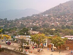
Kiwu Południowe
| prowincja | |
 | |
| Państwo | |
|---|---|
| Siedziba | Bukavu |
| Powierzchnia | 65 070 km² |
| Populacja (1998) • liczba ludności | 2 837 779 |
| • gęstość | 43,61 os./km² |
Położenie na mapie Demokratycznej Republiki Konga | |
Kiwu Południowe (fr. Sud-Kivu) – prowincja w Demokratycznej Republice Konga. Stolicą prowincji jest Bukavu.
Media użyte na tej stronie
Flag of the Democratic Republic of the Congo.svg
The national flag of the Democratic Republic of the Congo. Created according to the 2006 constitution : Son emblème est le drapeau bleu ciel, orné d’une étoile jaune dans le coin supérieur gauche et traversé en biais d’une bande rouge finement encadrée de jaune. (Its symbol is a sky blue flag, decorated with a yellow star in the upper left corner and crossed in the diagonal by a red strip with thin yellow borders) It seems to be identical, except for a lighter field hue, to the 1966–1971 flag.
The national flag of the Democratic Republic of the Congo. Created according to the 2006 constitution : Son emblème est le drapeau bleu ciel, orné d’une étoile jaune dans le coin supérieur gauche et traversé en biais d’une bande rouge finement encadrée de jaune. (Its symbol is a sky blue flag, decorated with a yellow star in the upper left corner and crossed in the diagonal by a red strip with thin yellow borders) It seems to be identical, except for a lighter field hue, to the 1966–1971 flag.
DCongoSouthKivu.png
Autor: User Morwen on en.wikipedia, Licencja: CC-BY-SA-3.0
Locator map showing a province of the en:Democratic Republic of Congo
Autor: User Morwen on en.wikipedia, Licencja: CC-BY-SA-3.0
Locator map showing a province of the en:Democratic Republic of Congo
Uvira, DR Congo.jpg
Autor: DBlomgren, Licencja: CC BY-SA 3.0
view of Uvira in Sud-Kivu territory, looking west
Autor: DBlomgren, Licencja: CC BY-SA 3.0
view of Uvira in Sud-Kivu territory, looking west


