Klasztor Banz
| Państwo | |
|---|---|
| Kraj związkowy | |
| Miejscowość | |
| Kościół | |
| Właściciel | |
Położenie na mapie Bawarii  | |
Położenie na mapie Niemiec  | |
| 50,132466°N 11,001054°E/50,132466 11,001054 | |
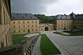
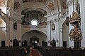
Klasztor Banz – były barokowy klasztor benedyktynów, znajdujący się w Bad Staffelstein.
Galeria
- Klasztor Banz - Kloster Banz


Źródła
- Hans-Werner Alt: Kloster Banz. 5. Auflage. Langewiesche, Königstein i. Ts. 2013, ISBN 978-3-7845-0195-6.
Media użyte na tej stronie
Bavaria location map G.svg
Autor: Hanhil based upon previous work by TUBS, Licencja: CC BY-SA 3.0
Location map Bavaria, showing position of Bavaria within Germany. Geographic limits of the map:
Autor: Hanhil based upon previous work by TUBS, Licencja: CC BY-SA 3.0
Location map Bavaria, showing position of Bavaria within Germany. Geographic limits of the map:
Germany location map.svg
Autor: NordNordWest, Licencja: CC BY-SA 3.0
Location map of Germany (Wp article: en:Germany)
Autor: NordNordWest, Licencja: CC BY-SA 3.0
Location map of Germany (Wp article: en:Germany)

.svg)

Legenda klasztor.svg
Symbol klasztoru do legendy mapy
Symbol klasztoru do legendy mapy

Kloster Banz-68-Kirche-Hauptaltar-2013-gje.jpg
Autor: Gerd Eichmann, Licencja: CC BY-SA 4.0
Kloster Banz
Autor: Gerd Eichmann, Licencja: CC BY-SA 4.0
Kloster Banz

Kloster Banz-16-durch Bruecke-2014-gje.jpg
Autor: Gerd Eichmann, Licencja: CC BY-SA 4.0
Kloster Banz
Autor: Gerd Eichmann, Licencja: CC BY-SA 4.0
Kloster Banz


Kloster Banz-74-Kirche-Orgelempore-2013-gje.jpg
Autor: Gerd Eichmann, Licencja: CC BY-SA 4.0
Kloster Banz
Autor: Gerd Eichmann, Licencja: CC BY-SA 4.0
Kloster Banz

Ebensfeld Ansberg Winter-20170106-RM-105542.jpg
(c) Reinhold Möller, CC BY-SA 4.0
View from Ansberg near Ebensfeld to Banz Monastery and the Thuringian Forest and the transmitter tower on the big Inselsberg
(c) Reinhold Möller, CC BY-SA 4.0
View from Ansberg near Ebensfeld to Banz Monastery and the Thuringian Forest and the transmitter tower on the big Inselsberg


Kloster Banz-60-Kirche-zum Chor-2006-gje.jpg
Autor: Gerd Eichmann, Licencja: CC BY-SA 4.0
Kloster Banz
Autor: Gerd Eichmann, Licencja: CC BY-SA 4.0
Kloster Banz