Kościół Saint Jean de Montmartre
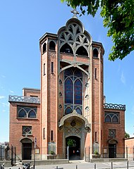
(c) Peter Haas, CC BY-SA 3.0 | |||||||||||
| Państwo | |||||||||||
|---|---|---|---|---|---|---|---|---|---|---|---|
| Miejscowość | Paryż | ||||||||||
| Wyznanie | katolickie | ||||||||||
| Kościół | rzymskokatolicki | ||||||||||
| Wezwanie | św. Jana | ||||||||||
| |||||||||||
| |||||||||||
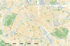
Położenie na mapie Paryża (c) Eric Gaba, Wikimedia Commons user Sting, CC BY-SA 3.0 | |||||||||||
Kościół Saint Jean de Montmartre, pol. kościół św. Jana w Montmartre – kościół rzymskokatolicki położony w paryskiej 18 okręgu paryskim.
Kościół św. Jana znajduje się u stóp wzgórza Montmartre. Został zbudowany w latach 1894-1904 przez Anatole de Baudot, architekta oraz ucznia Eugène Violleta-le-Duca oraz Henri Labrouste. Kościół został zbudowany w stylu secesyjnym[1]. Na konstrukcję składa się szkielet żelbetowy (po raz pierwszy zastosowany w budynku sakralnym), obudowany cienkimi ścianami zewnętrznymi z cegły. Liczne witraże w kościele zostały zaprojektowane oraz wykończone przez Jaca Gallanda natomiast rzeźby które ozdabiają wnętrze świątyni zostały zbudowane przez Pierre Rochea.
Organy kościelne zostały zbudowane przez Aristide Cavaillé-Colla w 1852 roku w jego pracowni w Lyonie. Renowacja instrumentów odbyła się w 1979 roku[2].
Metro
Najbliższą stacją paryskiego metra jest Abbesses[1].
Przypisy
- ↑ a b Paryż. Montmartre. Plac Pigalle i Place des Abbesses. Podróże na gazeta.pl, 2011-08-05. [dostęp 2012-04-17].
- ↑ Hsitoire de la genèse de l’Eglise Saint Jean de Montmartre, et origines de son mobilier religieux. (fr.). Oficjalna strona poświęcona kościołowi św. Jana w Montmartre. [dostęp 2012-04-17]. [zarchiwizowane z tego adresu (2013-12-03)].
Media użyte na tej stronie
(c) Eric Gaba, Wikimedia Commons user Sting, CC BY-SA 3.0
Blank land cover map of the city and department of Paris, France, as in January 2012, for geo-location purpose, with distinct boundaries for departments and arrondissements.
Autor: Superbenjamin, Licencja: CC BY-SA 4.0
Blank administrative map of France for geo-location purpose, with regions and departements distinguished. Approximate scale : 1:3,000,000
Autor: Thibault Pelloquin, Licencja: CC BY-SA 3.0
Cette carte représente l'Île de France (en jaune pâle), ses limites départementales et régionales (en traits gris) et ses principaux cours et points d'eau (en bleu). Les départements limitrophes (sont en rose-orange pâle)
Blue Shield - the Distinctive emblem for the Protection of Cultural Property. The distinctive emblem is a protective symbol used during armed conflicts. Its use is restricted under international law.
(c) Peter Haas, CC BY-SA 3.0
This building is indexed in the base Mérimée, a database of architectural heritage maintained by the French Ministry of Culture, under the reference PA00086740


