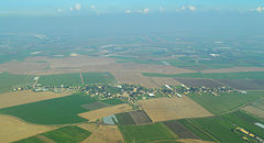
Komemijjut
 | |
| Państwo | |
|---|---|
| Dystrykt | Południowy |
| Wysokość | 76 m n.p.m. |
| Populacja (2006) • liczba ludności | 248 |
| Portal | |
Komemijjut (hebr. קוממיות; w oficjalnej pisowni ang. Komemiyut) – moszaw położony w Samorządzie Regionu Szafir, w Dystrykcie Południowym, w Izraelu.
Położenie
Leży w północno-zachodniej części pustyni Negew w pobliżu miasta Kirjat Gat.
Historia
Moszaw został założony w 1950.
Jednym z jego założycieli był rabin Szelomo Lorincz[1].
Gospodarka
Gospodarka moszawu opiera się na intensywnym rolnictwie i sadownictwie.
Przypisy
- ↑ Szelomo Lorincz (ang.) – profil na stronie Knesetu.
Linki zewnętrzne
Media użyte na tej stronie
Autor: NordNordWest, Licencja: CC BY-SA 3.0
Flag of Israel. Shows a Magen David (“Shield of David”) between two stripes. The Shield of David is a traditional Jewish symbol. The stripes symbolize a Jewish prayer shawl (tallit).
Autor: Amos Meron, Licencja: CC BY-SA 3.0
Komemiyut Aerial View. Behind on the right is Nir Banim and behind in the center is Zrachya. On the left is Moshav Shafir, behind it is Avigdor and further behind are teh white buildings of Kiryat Malachi. The picture was taken from south west.


