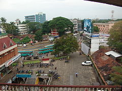
Kozhikode
| Ten artykuł od 2012-06 wymaga zweryfikowania podanych informacji. |
| ||
 | ||
| Państwo | ||
| Stan | Kerala | |
| Dystrykt | Kozhikode | |
| Burmistrz | M. Bhaskaran | |
| Powierzchnia | 82,68 km² | |
| Wysokość | 1 m n.p.m. | |
| Populacja (2001) • liczba ludności • gęstość | 436 556 5280 os./km² | |
| Kod pocztowy | 673001 | |
Położenie na mapie Indii | ||
| Strona internetowa | ||
Kozhikode (hist. Kalikat; malajalam കോഴിക്കോട്, trl. Kōḻikkōṭ; ang. Kozhikode, dawniej Calicut; hindi कोष़िक्कोड, trl. Koḻikkoḍ, trb. Kolikkod, dawniej कालीकट, trl. Kālīkaṭ, trb. Kalikat) – miasto w Indiach; trzecie co do wielkości miasto w stanie Kerala. Ludność: 801 190 (1991).
Miasto od ok. XIII w., jeszcze przed dopłynięciem do niego Europejczyków, było ważnym ośrodkiem handlu przyprawami, którym zajmowali się Arabowie i Chińczycy. Do Kalikatu dotarł Vasco da Gama podczas swojej pierwszej wyprawy do Indii w 1498, lądując na plaży 18 km od obecnego miasta.
Media użyte na tej stronie
(c) Uwe Dedering z niemieckiej Wikipedii, CC BY-SA 3.0
Location map of India.
Equirectangular projection. Strechted by 106.0%. Geographic limits of the map:
- N: 37.5° N
- S: 5.0° N
- W: 67.0° E
- E: 99.0° E
The Flag of India. The colours are saffron, white and green. The navy blue wheel in the center of the flag has a diameter approximately the width of the white band and is called Ashoka's Dharma Chakra, with 24 spokes (after Ashoka, the Great). Each spoke depicts one hour of the day, portraying the prevalence of righteousness all 24 hours of it.
Autor: NordNordWest, Licencja: CC BY-SA 3.0 de
Location map of Kerala, India
Autor: Bryce Edwards from Dunedin, New Zealand, Licencja: CC BY 2.0
View of Kochi-Panavel Rd from Hotel Malabar Palace, Kozhikode, India (11.253 N, 75.784 E).


