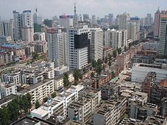
Kunming
 Centrum miasta | |
| Państwo | |
|---|---|
| Prowincja | |
| Powierzchnia | 712 km² |
| Wysokość | 1892 m n.p.m. |
| Populacja (2018) • liczba ludności |
|
| Nr kierunkowy | 0871 |
| Kod pocztowy | 650000 |
| Tablice rejestracyjne | 云A |
 | |
| Strona internetowa | |
| Portal | |
Kunming (chiń. 昆明; pinyin: Kūnmíng) – miasto o statusie prefektury miejskiej w południowych Chinach, stolica prowincji Junnan.
Warunki naturalne
Miasto leży na Wyżynie Junnan-Kuejczou, na północnym brzegu jeziora Dian (滇池). Ze względu na uwarunkowania pogodowe Kunming jest często nazywany Wiosennym Miastem (春城, Chūnchéng).
Społeczeństwo
Wszystkie 26 grup etnicznych prowincji Junnan zamieszkują teren miasta Kunming.
Gospodarka
Ośrodek przemysłu metalurgicznego, maszynowego, elektrotechnicznego, nawozów azotowych i precyzyjnego[2].
Transport
Kultura
Siedziba katolickiej archidiecezji. Dawniej miasto nosiło nazwę Yunnanfu (云南府).
Atrakcje turystyczne
- Pagoda Dongsi Ta
- Pagoda Xisi Ta
- Yuantong Si
- Cui Hu – Zielone Jezioro z pawilonami nad brzegiem
Miasta partnerskie
Przypisy
- ↑ Demographia: World Urban Areas.
- ↑ Kunming, [w:] Encyklopedia PWN [online] [dostęp 2010-12-05].
- ↑ 中国国际友好城市联合会. [dostęp 2021-06-25]. [zarchiwizowane z tego adresu (2019-03-26)].
Media użyte na tej stronie
Autor: Uwe Dedering, Licencja: CC BY-SA 3.0
Location map of China.
EquiDistantConicProjection : Central parallel :
- N: 36.0° N
Central meridian :
- E: 104.0° E
Standard parallels:
- 1: 30.0° N
- 2: 42.0° N
Latitudes on the central meridian :
- top: 57.0° E
- center: 37° 29′ N
- bottom: 17.96° N
The Flag of India. The colours are saffron, white and green. The navy blue wheel in the center of the flag has a diameter approximately the width of the white band and is called Ashoka's Dharma Chakra, with 24 spokes (after Ashoka, the Great). Each spoke depicts one hour of the day, portraying the prevalence of righteousness all 24 hours of it.
The flag of Navassa Island is simply the United States flag. It does not have a "local" flag or "unofficial" flag; it is an uninhabited island. The version with a profile view was based on Flags of the World and as a fictional design has no status warranting a place on any Wiki. It was made up by a random person with no connection to the island, it has never flown on the island, and it has never received any sort of recognition or validation by any authority. The person quoted on that page has no authority to bestow a flag, "unofficial" or otherwise, on the island.
Autor: NordNordWest, Licencja: CC BY-SA 3.0 de
Location map of Yunnan, People's Republic of China
Kunming skyline
Autor: Croquant, Licencja: CC BY 3.0
English: Location of Kunming prefecture (yellow) within Yunnan province of China.
简体中文: 昆明市在中华人民共和国云南省的位置。
繁體中文: 昆明市在中華人民共和國雲南省的位置。
Map drawn in september 2007 using various sources, mainly :


