Lānaʻi
| ||
 Zdjęcie wyspy z satelity Landsat | ||
| Państwo | ||
| Akwen | Ocean Spokojny | |
| Archipelag | Hawaje | |
| Powierzchnia | 363,968 km² | |
| Populacja (2000) • liczba ludności • gęstość | 3193 9 os./km² | |
 | ||
Lānaʻi – wyspa należąca do Hawajów. Jest szóstą co do wielkości hawajską wyspą. Znana również jako Wyspa Ananasów, ze względu na dużą liczbę ich plantacji w przeszłości.
Powierzchnia Lanaʻi wynosi 364 km², a żyje na niej około 3000 osób.
W 2012 roku 98% powierzchni wyspy zakupił Larry Ellison – Prezes Oracle Corporation[1].
Przypisy
- ↑ Miliarder kupił "ananasową wyspę" na Hawajach - Wiadomości - polskieradio.pl, www.polskieradio.pl [dostęp 2017-11-25].
| ||||||||||||||||||||
Media użyte na tej stronie
The flag of Navassa Island is simply the United States flag. It does not have a "local" flag or "unofficial" flag; it is an uninhabited island. The version with a profile view was based on Flags of the World and as a fictional design has no status warranting a place on any Wiki. It was made up by a random person with no connection to the island, it has never flown on the island, and it has never received any sort of recognition or validation by any authority. The person quoted on that page has no authority to bestow a flag, "unofficial" or otherwise, on the island.
Autor: NordNordWest, Licencja: CC BY-SA 3.0 de
Location map of Hawaii, USA
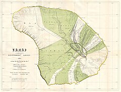
This rare and extraordinary 1878 map of the island of Lanai, in the Hawaiian group, was prepared for the 1906 Report of the Governor of the Territory of Hawaii to the Secretary of the Interior. Though the cartographic work that produced this map was started in 1878, during the Hawaiian Monarchy, the map itself, and the report that contained it, was issued following the U.S. Government’s 1898 annexation of the Hawaiian Republic. The Report was an attempt to assess and examine the newly created Hawaiian Territory’s potential for proper administration and development. Consequently the map focuses on Public Lands, Homestead Settlement Tracts, Grazing Lands, Pineapple Lands, Sugar Plantations, Forest Reserves, Forest Lands, Wet Lands, etc. It also features both practical and topographic details for use in administering the region. The governor at this time was George R. Carter. The primary triangulation for this map was accomplished by J. F. Brown and M. D Monsarrat. The survey work was done by Walter E. Wall. This map is heavily based upon the H. E Newton Government Survey Regional Map No. 1394.
Autor: Uwe Dedering, Licencja: CC BY-SA 3.0
Relief location map of Pacific_Ocean.
- Projection: Lambert azimuthal equal-area projection.
- Area of interest:
- N: 60.0° N
- S: −80.0° N
- W: −260.0° E
- E: −70.0° E
- Projection center:
- NS: −10.0° N
- WE: −165.0° E
- GMT projection: -JA-165.0/-10.0/180/19.998266666666666c
- GMT region: -R-320.2519138145009/-12.459450078533589/-5.473602099069988/26.40516525873812r
- GMT region for grdcut: -R-325.0/-90.0/-5.0/74.0r
- Relief: SRTM30plus.
- Made with Natural Earth. Free vector and raster map data @ naturalearthdata.com.


