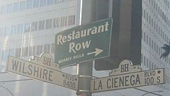
La Cienega Boulevard
| ||
 Tabliczka z nazwą ulicy na skrzyżowaniu z Wilshire Boulevard w mieście Beverly Hills | ||
| Państwo | ||
| Miejscowość | Los Angeles | |
| Plan | ||
 | ||
La Cienega Boulevard – ulica w hrabstwie Los Angeles biegnąca z południa na północ. Zaczyna się w mieście El Segundo kończy przy Sunset Strip/Sunset Boulevard. Nazwa pochodzi od nazwy rancza "Las Ciénegas" znajdującego się na terenie dzisiejszego West Hollywood. La Ciénaga po hiszpańsku oznacza "bagno".
| ||||||||||||||||||
Media użyte na tej stronie
Autor: Alexrk2, Licencja: CC BY 3.0
Ta mapa została stworzona za pomocą GeoTools.
Autor: Uwe Dedering, Licencja: CC BY-SA 3.0
Location map of the USA (without Hawaii and Alaska).
EquiDistantConicProjection:
Central parallel:
* N: 37.0° N
Central meridian:
* E: 96.0° W
Standard parallels:
* 1: 32.0° N
* 2: 42.0° N
Made with Natural Earth. Free vector and raster map data @ naturalearthdata.com.
Formulas for x and y:
x = 50.0 + 124.03149777329222 * ((1.9694462586094064-({{{2}}}* pi / 180))
      * sin(0.6010514667026994 * ({{{3}}} + 96) * pi / 180))
y = 50.0 + 1.6155950752393982 * 124.03149777329222 * 0.02613325650382181
      - 1.6155950752393982  * 124.03149777329222 *
     (1.3236744353715044  - (1.9694462586094064-({{{2}}}* pi / 180))
      * cos(0.6010514667026994 * ({{{3}}} + 96) * pi / 180))
Autor: NordNordWest, Licencja: CC BY 3.0
Location map of California, USA
The flag of Navassa Island is simply the United States flag. It does not have a "local" flag or "unofficial" flag; it is an uninhabited island. The version with a profile view was based on Flags of the World and as a fictional design has no status warranting a place on any Wiki. It was made up by a random person with no connection to the island, it has never flown on the island, and it has never received any sort of recognition or validation by any authority. The person quoted on that page has no authority to bestow a flag, "unofficial" or otherwise, on the island.
Crossroads with a major road ahead.
Autor: Minnaert, Licencja: CC BY-SA 4.0
Beginning of La Cienega Boulevard, at intersection with Sunset Boulevard, in West Hollywood, California.
- View to south.
Restaurant Row street sign in Beverly Hills, CA. Corner of Wilshire Blvd and La Cienega Blvd


