La Plata (estuarium)
 Zdjęcie satelitarne estuarium La Plata | |
| Państwo | |
|---|---|
| Lokalizacja | |
| Powierzchnia | 35 tys. km² |
| Wymiary | 320 × 80 – 220 km |
| Cieki wodne uchodzące | |
| Miejscowości nadbrzeżne | |
 | |
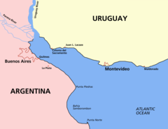
La Plata (hiszp. Río de la Plata, port. Rio da Prata) – olbrzymie estuarium, powstałe z połączenia ujściowych odcinków rzek Parany i Urugwaj do Oceanu Atlantyckiego.
Powierzchnia estuarium wynosi 35 tys. km². Długość 320 km, szerokość maksymalna 220 km[1]. Jego szerokość maleje wraz z odległością od oceanu. Średni przepływ u ujścia 22 tys. m³/s. Średnia suma opadów na obszarze La Platy wynosi około 1120 mm[2].
Nad La Platą – leżącą na granicy Argentyny i Urugwaju – znajdują się stołeczne miasta Buenos Aires i Montevideo[1].
Zobacz też
- Bitwa u ujścia La Platy
- Rzeki Ameryki Południowej
- Trzęsienie ziemi w regionie La Platy (1888)
Przypisy
- ↑ a b Encyklopedia Powszechna PWN. T. 2. G-M. Warszawa: Państwowe Wydawnictwo Naukowe, 1974.
- ↑ Río de la Plata, [w:] Encyclopædia Britannica [online] [dostęp 2014-08-21] (ang.).
Media użyte na tej stronie
NASA astronaut photograph of the Río de la Plata estuary looking west-east, the picture does not show a north and south view. Actually the right is the south and the bottom of the picture is the west. Note Greater Buenos Aires on the right side of the picture, and Montevideo on the left side (near the mouth of the Santa Lucía. To the east of Greater Buenos Aires, a smaller conurbation is visible, including La Plata (a few kilometers inland) and the Berisso-Ensenada area (near the river). Water on the river is brown because of sediments carried from the Paraná and Uruguay rivers. The color turns blue when approaching the South Atlantic Ocean. The exact location of the color change (which also implies a change from fresh to salt water) depends on winds and currents.
Autor:
- Argentina_location_map.svg: NordNordWest
- derivative work: Виктор В (talk)
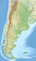
Location map of Argentina


