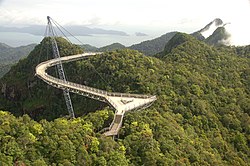
Langkawi
 | |
| Kontynent | |
|---|---|
| Państwo | |
| Akwen | |
| 6°21′N 99°48′E/6,350000 99,800000 | |
Langkawi - archipelag na Morzu Andamańskim, w odległości 30 km na zachód od północnej części Półwyspu Malajskiego. Składa się ze 104 wysp, z których największą jest wyspa Langkawi, z głównym miastem Kuah. Administracyjnie archipelag stanowi część malezyjskiego stanu Kedah, graniczącego z Tajlandią. Od lat 80 XX w. rozwijana infrastruktura turystyczna.
Bibliografia
- H. Finlay, P.Turner: Malaysia, Singapore & Brunei - a travel survival kit Lonely Planet, ISBN 0-86442-211-3
Linki zewnętrzne
Media użyte na tej stronie
Autor: Uwe Dedering, Licencja: CC BY-SA 3.0
Location map of Malaysia.
Equirectangular projection. Strechted by 100.0%. Geographic limits of the map:
* N: 8.0° N
* S: 0.0° N
* W: 99.0° E
* E: 120.0° E
Made with Natural Earth. Free vector and raster map data @ naturalearthdata.com.
Autor: Azreey, Licencja: CC BY-SA 3.0
A view of Kuah town, the commercial center of Pulau Langkawi.
Autor: Flickr user "The Dilly Lama", Licencja: CC BY 2.0
The Langkawi Sky Bridge, Malaysia
Shiny LightSteelBlue button/marker widget. Used to mark the location of something such as a tourist attraction.
(c) Kelisi z angielskojęzycznej Wikipedii, CC-BY-SA-3.0
Langkawi, Kedah, Malaysia and nearby areas in Malaysia and Thailand. This map's source is here, with the uploader's modifications, and the GMT homepage says that the tools are released under the GNU General Public License.


