Larche (Alpy Górnej Prowansji)
| miejscowość | |
 | |
| Państwo | |
|---|---|
| Region | |
| Departament | |
| Okręg | |
| Kanton | |
| Kod INSEE | 04100 |
| Mer | Yves Nicolas (2014-2020) |
| Powierzchnia | 68,86 km² |
| Wysokość | 1606-3165 m n.p.m. |
| Populacja (2013) • liczba ludności |
|
| Kod pocztowy | 04540 |
| Portal | |
Larche – miejscowość i dawna gmina we Francji, w regionie Prowansja-Alpy-Lazurowe Wybrzeże, w departamencie Alpy Górnej Prowansji. W dniu 1 stycznia 2016 roku z połączenia dwóch ówczesnych gmin – Larche oraz Meyronnes – powstała nowa gmina Val d’Oronaye[1]. W 2013 roku populacja Larche wynosiła 57 mieszkańców[2].
Przypisy
- ↑ Liste du Recueil des Actes Administratif d'Octobre à Décembre (fr.). alpes-de-haute-provence.gouv.fr. [dostęp 2016-11-15].
- ↑ Populations légales 2013 - 04100-Larche (fr.). INSEE. [dostęp 2016-11-15].
Media użyte na tej stronie
Autor: Superbenjamin, Licencja: CC BY-SA 4.0
Blank administrative map of France for geo-location purpose, with regions and departements distinguished. Approximate scale : 1:3,000,000
Autor: Flappiefh, Licencja: CC BY-SA 4.0
Blank administrative map of the region of Provence-Alpes-Côte d'Azur, France, for geo-location purpose.
Autor: Flappiefh, Licencja: CC BY-SA 4.0
Blank administrative map of the department of Alpes-de-Hautes-Provence, France, for geo-location purpose.
Autor: Berrucomons, Licencja: CC BY-SA 3.0
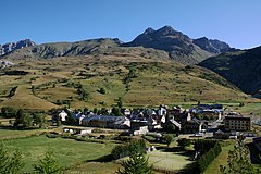
The village of Larche, in the Ubayette Valley. Alpes-de-Haute-Provence département, France. The following summits are visible behind the village, from the left to the right: The Tête des Bréquets (Litt.: Head of the Bréquets), the Côte des Chamois (Litt.: Slope of the Chamois), The Meyna, the Tête de la Virrayasse, and the Tête de Sautron.


