Latarnia morska Corsewall
| ||
(c) Mary and Angus Hogg, CC BY-SA 2.0 | ||
| Państwo | ||
| Kraj | ||
| Miejscowość | Stranraer | |
| Wysokość wieży | 34 m | |
| Wysokość światła | 34 m n.p.m. | |
| Zasięg światła | 22 Mm | |
| Charakterystyka światła | 5 białych błysków co 30 s.[1] | |
| Data budowy | 1814–1817 | |
| Data uruchomienia | 1817 | |
| Administrator | Northern Lighthouse Board | |
Położenie na mapie Dumfries and Galloway Contains Ordnance Survey data © Crown copyright and database right, CC BY-SA 3.0 | ||
Położenie na mapie Wielkiej Brytanii (c) Karte: NordNordWest, Lizenz: Creative Commons by-sa-3.0 de | ||
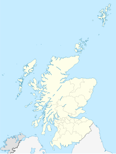
Położenie na mapie Szkocji | ||
| Strona internetowa | ||
Latarnia morska Corsewall – zbudowana w roku 1817 przez szkockiego inżyniera Roberta Stevensona, dziadka Roberta Louisa Stevensona dla Northern Lighthouse Board. Położona jest na przylądku Corsewall Point około 6 kilometrów na północny zachód od wioski Kirkcolm i 18 kilometrów od Stranraer na półwyspie Rhins of Galloway w Dumfries and Galloway. Latarnia została wpisana w 1972 roku na listę zabytków kategorii A Historic Scotland pod numerem 9923[2]. Obiekt znajduje się także na liście Royal Commission on the Ancient and Historical Monuments of Scotland pod numerem NW97SE 15[3].
W 1994 roku latarnia została zautomatyzowana i jest sterowana z centrum w Edynburgu[1]. W tym samym roku sąsiadujące budynki zostały sprzedane. Obecnie mieści się w nich czterogwiazdkowy Lighthouse Hotel, Corsewall Point.
Przypisy
- ↑ a b Corsewall (ang.). Northern Lighthouse Board, Lighthouse Liibrary. [dostęp 2014-05-16]. [zarchiwizowane z tego adresu (2006-10-02)].
- ↑ CORSEWALL LIGHTHOUSE, LIGHTHOUSE KEEPERS' HOUSES AND ENCLOSURE WALLS (Ref:9923) (ang.). Historic Scotland Data Services. [dostęp 2014-05-16].
- ↑ Corsewall Point Lighthouse; Kirkcolm; Corsewall (ang.). Royal Commission on the Ancient and Historical Monuments of Scotland. [dostęp 2014-05-16].
Media użyte na tej stronie
(c) Karte: NordNordWest, Lizenz: Creative Commons by-sa-3.0 de
Location map of the United Kingdom
Symbol latarnii do legendy mapy
Contains Ordnance Survey data © Crown copyright and database right, CC BY-SA 3.0
Blank map of Dumfries and Galloway, UK with the following information shown:
- Administrative borders
- Coastline, lakes and rivers
- Roads and railways
- Urban areas
Equirectangular map projection on WGS 84 datum, with N/S stretched 170%
Geographic limits:
- West: 5.25W
- East: 2.75W
- North: 55.50N
- South: 54.50N
(c) Mary and Angus Hogg, CC BY-SA 2.0
Corsewell Lighthouse and Hotel
(c) Eric Gaba, NordNordWest, CC BY-SA 3.0
Location map of Scotland, United Kingdom


