Latarnia morska Crow Point
(c) Rabbi WP Thinrod, CC BY-SA 2.0 | |
| Państwo | |
|---|---|
| Miejscowość | |
| Wysokość wieży | 5 m |
| Wysokość światła | 7,6 m n.p.m. |
| Zasięg światła | 6 Mm |
| Charakterystyka światła | błysk co 2,5 s. |
| Data budowy | 1954 |
| Data uruchomienia | 1954 |
| Administrator | Trinity House Operations and Planning Centre |
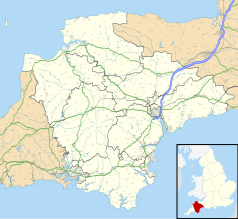
Położenie na mapie Devonu Contains Ordnance Survey data © Crown copyright and database right, CC BY-SA 3.0 | |
Położenie na mapie Wielkiej Brytanii (c) Karte: NordNordWest, Lizenz: Creative Commons by-sa-3.0 de | |
Latarnia morska Crow Point – latarnia morska położona piaszczystym północnym brzegu wspólnego ujścia rzek Taw oraz Torridge, naprzeciw wsi Appledore, Devon.
5 metrowa stalowa wieża została zbudowana w 1954 roku. Latarnia została przebudowana na latarnię słoneczną w 1987 roku. Stacja jest monitorowana z Trinity House Operations & Planning Centre w Harwich[1]. Ponownie zmodernizowano latarnię w 2001 roku[2].
Przypisy
- ↑ Crow Point. Trinity House, Lighthouse List. [dostęp 2014-01-18]. (ang.).
- ↑ Crow Point Lighthouse. Worldwide Lighthouses. [dostęp 2014-01-18]. (ang.).
Media użyte na tej stronie
(c) Karte: NordNordWest, Lizenz: Creative Commons by-sa-3.0 de
Location map of the United Kingdom
Contains Ordnance Survey data © Crown copyright and database right, CC BY-SA 3.0
Map of Devon, UK with the following information shown:
- Administrative borders
- Coastline, lakes and rivers
- Motorways and primary routes
- Urban areas
Equirectangular map projection on WGS 84 datum, with N/S stretched 150%
Geographic limits:
- West: 4.72W
- East: 2.86W
- North: 51.3N
- South: 50.16N
Symbol latarnii do legendy mapy
(c) Rabbi WP Thinrod, CC BY-SA 2.0
Crow Point Low Spring tides expose large sand banks known as The Neck. The light, marking the junction of the Taw, Torridge and the seaway, has seen less commercial traffic since the demise of Yelland Power Station across the river. The light is operated by Trinity House and was converted to solar power in 1987.


