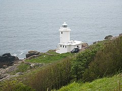
Latarnia morska Tater Du
| ||
(c) Rod Allday, CC BY-SA 2.0 | ||
| Państwo | ||
| Miejscowość | St Buryan | |
| Wysokość wieży | 15 m | |
| Wysokość światła | 34 m n.p.m. | |
| Zasięg światła | 23 Mm | |
| Charakterystyka światła | 3 białe błyski co 15 sekund, 2940000 kandeli białe | |
| Data budowy | 1965 | |
| Data uruchomienia | 1965 | |
| Administrator | Trinity House Operations and Planning Centre | |
Położenie na mapie Kornwalii Contains Ordnance Survey data © Crown copyright and database right, CC BY-SA 3.0 | ||
Położenie na mapie Wielkiej Brytanii (c) Karte: NordNordWest, Lizenz: Creative Commons by-sa-3.0 de | ||
Latarnia morska Tater Du – latarnia morska położona około 3 kilometrów na południowy wschód od wioski St Buryan i około 8 km na południe od Penzance, Kornwalia. Latarnia została zbudowana przez Trynity House i oddana do użytku w 1965 roku. Budowa latarni była konsekwencją wypadku, jaki zdarzył się w pobliżu. 23 października 1963 roku w czasie sztormu hiszpański frachtowiec MV „Juan Ferrer” wpadł na pobliskie skały. Z 15-osobowej załogi zginęło 11 marynarzy[1].
Wieża latarni ma przekrój okrągły i wznosi się na 19 metrów nad poziom gruntu, a lampa usytuowana jest 34 metry nad poziomem morza. Zwieńczona jest laterną oraz galerią.
W latach 1996-1997 latarnia została zmodernizowana i jest obecnie sterowana z Penzance. Emitowany sygnał świetlny: 3 białe błyski o okresie 15 minut.
Przypisy
- ↑ MV Juan Ferrer (+1963) (ang.). W: WreckSite [on-line]. wrecksite.eu. [dostęp 2014-01-04].
Bibliografia
- Tater Du – history (ang.). Lighthouse List, Trinity House. [dostęp 2014-01-04].
- Russ Rowlett, University of North Carolina at Chapel Hill: Round Island lighthouse (ang.). The Lighthouse Directory. [dostęp 2014-01-01].
Media użyte na tej stronie
Contains Ordnance Survey data © Crown copyright and database right, CC BY-SA 3.0
Map of Cornwall, UK with the following information shown:
- Administrative borders
- Coastline, lakes and rivers
- Roads and railways
- Urban areas
Equirectangular map projection on WGS 84 datum, with N/S stretched 150%
Geographic limits:
- West: 6.47W
- East: 4.00W
- North: 51.04N
- South: 49.83N
(c) Karte: NordNordWest, Lizenz: Creative Commons by-sa-3.0 de
Location map of the United Kingdom
Symbol latarnii do legendy mapy
(c) Rod Allday, CC BY-SA 2.0
Tater-du lighthouse Seen from the coastal path.
(c) Tom Corser www.tomcorser.com, CC BY-SA 3.0
Tatterdoo lighthouse Lamorna Cornwall
|
This photo was taken by Tom Corser and is © Tom Corser 2020. This photo may be reproduced under the terms of the Creative Commons Attribution-ShareAlike 3.0 Unported Licence [1] (unless otherwise stated). Please credit this photo Tom Corser www.tomcorser.com. If using this photo, make sure you properly credit and specify the licence that this photo is licensed under. (E.g. "Photo by Tom Corser www.tomcorser.com. Licensed under Creative Commons Attribution-ShareAlike 3.0 Unported Licence: https://creativecommons.org/licenses/by-sa/3.0/legalcode"). If you would like to use this photo under a different license, please contact me via www.tomcorser.com[2] or email tomcorser@gmail.com. |
|
|
Ten plik udostępniony jest na licencji Creative Commons Uznanie autorstwa – Na tych samych warunkach 3.0. | |
| Uznanie autorstwa: Tom Corser www.tomcorser.com | ||
|


