Latarnia morska Trevose Head
| ||
 | ||
| Państwo | ||
| Miejscowość | Padstow | |
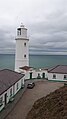
| Wysokość wieży | 27 m | |
| Zasięg światła | 20 Mm | |
| Charakterystyka światła | biały błysk co 7.5 s. | |
| Data budowy | 1847 | |
| Data uruchomienia | 1847 | |
| Administrator | Trinity House Operations and Planning Centre | |
Położenie na mapie Kornwalii  Contains Ordnance Survey data © Crown copyright and database right, CC BY-SA 3.0 | ||
Położenie na mapie Wielkiej Brytanii  (c) Karte: NordNordWest, Lizenz: Creative Commons by-sa-3.0 de | ||
Położenie na mapie Anglii  | ||
Latarnia morska Trevose Head – latarnia morska położona na półwyspie Trevose Head, na klifach około 5 kilometrów na zachód od miasta Padstow, Kornwalia. Latarnia jest wpisana na listę English Heritage[1].
Została zaprojektowana przez Jamesa Walkera jako latarnia podwójna Trevose Head High i Trevose Head Low i zbudowana przez Jacob & Thomas Olver z Falmouth[2]. Uruchomiona została w 1847 roku[3]. Oba stałe światła były w użytku do 1882 roku[3].
Latarnia została zelektryfikowana w 1974 roku, a w pełni zautomatyzowana w 1995[3].
Obecnie zasięg światła białego wynosi 20 Mm, wysyłany sygnał to jeden biały błysk co 7.5 s. Stacja jest monitorowana z Trinity House Operations & Planning Centre w Harwich[3].
Podwórze

Detal
Przypisy
- ↑ TREVOSE LIGHTHOUSE, List entry Number: 1212769 (ang.). English Heritage. [dostęp 2014-01-13].
- ↑ 56. Trevose Head, High, 57. Trevose Head, Low (ang.). Lighthouse management : the report of the Royal Commissioners on Lights, Buoys, and Beacons, 1861, examined and refuted Vol. 2". pp. 92, 93.. [dostęp 2014-01-11].
- ↑ a b c d Trevose Head – history (ang.). Trinity House, Lighthouse List. [dostęp 2014-01-13]. [zarchiwizowane z tego adresu (2016-03-04)].
Media użyte na tej stronie
Contains Ordnance Survey data © Crown copyright and database right, CC BY-SA 3.0
Map of Cornwall, UK with the following information shown:
- Administrative borders
- Coastline, lakes and rivers
- Roads and railways
- Urban areas
Equirectangular map projection on WGS 84 datum, with N/S stretched 150%
Geographic limits:
- West: 6.47W
- East: 4.00W
- North: 51.04N
- South: 49.83N
(c) Karte: NordNordWest, Lizenz: Creative Commons by-sa-3.0 de
Location map of the United Kingdom

Symbol latarnii do legendy mapy

Autor: Nilfanion, Licencja: CC BY-SA 3.0
Trevose Head Lighthouse on the north Cornish coast.

Autor: Geertivp, Licencja: CC BY-SA 4.0
Trevose Head Lighthouse with courtyard
Autor: Nilfanion, Licencja: CC BY-SA 3.0
Trevose lighthouse on the North Coast of Cornwall.