Latur
 | |
| Państwo | |
|---|---|
| Stan | |
| Wysokość | 631 m n.p.m. |
| Populacja (2001) • liczba ludności |
|
| Nr kierunkowy | +02382 |
| Kod pocztowy | 413512, 413531 |
Położenie na mapie Indii | |
| Strona internetowa | |
Latur (marathi: लातुर) – miasto i gmina w Indiach, w stanie Maharashtra, stolica dystryktu Latur.
Historia
Miasto zostało założone w okresie rządów dynastii Raśtrakuta w VIII lub IX wieku. Do 1948 należało do Księstwa Hajdarabadu, następnie wchodziło w skład dystryktu Osmanabad w stanie Maharashtra. Od 16 sierpnia 1981 jest stolicą nowego dystryktu Latur.[1]
30 września 1993 roku miasto nawiedziło trzęsienie ziemi o sile 6,4 stopnia w skali Richtera.[2]
Geografia
Latur znajduje się na wysokości 631 m n.p.m. na równinie Balaghat. Miasto jest położone na pograniczu między stanami Maharashtra i Karnataka.
Demografia
Populacja w 2001 wynosiła 299 828 mieszkańców,[3] z czego 52% stanowią mężczyźni.
Przypisy
- ↑ Latur District At a glance Information (ang.). [dostęp 2008-11-21].
- ↑ The Earthquake (ang.). [dostęp 2008-11-21].
- ↑ Census of India: Table - 3 : Population, population in the age group 0-6 and literates by sex - Cities/Towns (in alphabetic order): 2001 (ang.). [dostęp 2008-11-21].
Media użyte na tej stronie
(c) Uwe Dedering z niemieckiej Wikipedii, CC BY-SA 3.0
Location map of India.
Equirectangular projection. Strechted by 106.0%. Geographic limits of the map:
- N: 37.5° N
- S: 5.0° N
- W: 67.0° E
- E: 99.0° E
The Flag of India. The colours are saffron, white and green. The navy blue wheel in the center of the flag has a diameter approximately the width of the white band and is called Ashoka's Dharma Chakra, with 24 spokes (after Ashoka, the Great). Each spoke depicts one hour of the day, portraying the prevalence of righteousness all 24 hours of it.
Autor: Maximilian Dörrbecker (Chumwa), Licencja: CC BY-SA 3.0
Location map of Maharashtra
Autor: Tafzal, Licencja: CC BY-SA 3.0
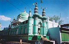
Surat Shawali Darga, Patel Chowk (1.5 km from Main S. T. Stand),Latur


