Laurel Canyon Boulevard
| ||
 | ||
| Państwo | ||
| Miejscowość | Los Angeles | |
Laurel Canyon Boulevard – ulica w hrabstwie Los Angeles biegnąca z północy na południe. Zaczyna się w północnej części doliny San Fernando kończy natomiast przy Sunset Boulevard w West Hollywood. Laurel Canyon Bolevard przebiega kanionem o tej samej nazwie przez górach Santa Monica, gdzie przecina m.in. Mulholland Drive. Jest to najbardziej widowiskowa część drogi. W tym rejonie położona jest także dzielnica Laurel Canyon w której mieszkają gwiazdy kina oraz muzyki.
| ||||||||||||||||||
Media użyte na tej stronie
Autor: Alexrk2, Licencja: CC BY 3.0
Ta mapa została stworzona za pomocą GeoTools.
Autor: Uwe Dedering, Licencja: CC BY-SA 3.0
Location map of the USA (without Hawaii and Alaska).
EquiDistantConicProjection:
Central parallel:
* N: 37.0° N
Central meridian:
* E: 96.0° W
Standard parallels:
* 1: 32.0° N
* 2: 42.0° N
Made with Natural Earth. Free vector and raster map data @ naturalearthdata.com.
Formulas for x and y:
x = 50.0 + 124.03149777329222 * ((1.9694462586094064-({{{2}}}* pi / 180))
      * sin(0.6010514667026994 * ({{{3}}} + 96) * pi / 180))
y = 50.0 + 1.6155950752393982 * 124.03149777329222 * 0.02613325650382181
      - 1.6155950752393982  * 124.03149777329222 *
     (1.3236744353715044  - (1.9694462586094064-({{{2}}}* pi / 180))
      * cos(0.6010514667026994 * ({{{3}}} + 96) * pi / 180))
Autor: NordNordWest, Licencja: CC BY 3.0
Location map of California, USA
The flag of Navassa Island is simply the United States flag. It does not have a "local" flag or "unofficial" flag; it is an uninhabited island. The version with a profile view was based on Flags of the World and as a fictional design has no status warranting a place on any Wiki. It was made up by a random person with no connection to the island, it has never flown on the island, and it has never received any sort of recognition or validation by any authority. The person quoted on that page has no authority to bestow a flag, "unofficial" or otherwise, on the island.
Crossroads with a major road ahead.
Autor: Downtowngal, Licencja: CC BY-SA 3.0
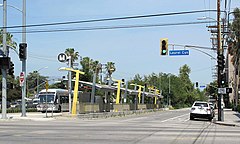
A westbound Orange Line bus passing the eastbound stop at Laurel Canyon Blvd. at Chandler Avenue, in the San Fernando Valley, Los Angeles, California.


