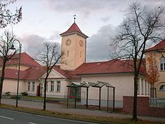
Lauta
 | |||
| |||
| Państwo | |||
|---|---|---|---|
| Kraj związkowy | |||
| Powiat | |||
| Powierzchnia | 41,87 km² | ||
| Wysokość | 175 m n.p.m. | ||
| Populacja (31 grudnia 2009) • liczba ludności • gęstość |
| ||
| Nr kierunkowy | 035722 | ||
| Kod pocztowy | 02991 | ||
| Tablice rejestracyjne | BZ, BIW, HY, KM | ||
| Strona internetowa | |||
| Portal | |||
Lauta (górnołuż Łuty) – miasto w Niemczech, w kraju związkowym Saksonia, w okręgu administracyjnym Drezno, w powiecie Budziszyn.
Bibliografia
- Statistisches Landesamt des Freistaates Sachsen, Kamenz, 2009
Media użyte na tej stronie
Autor: Hanhil based on work by TUBS, Licencja: CC BY-SA 3.0
Location map Saxony, showing position of Saxony within Germany. Geographic limits of the map:
Autor: NordNordWest, Licencja: CC BY-SA 3.0
Location map of Germany (Wp article: en:Germany)
The historical coat of arms of Upper Lusatia and the city of Bautzen in Saxony, Germany. Today this is the coat of arms of the district Bautzen.
Autor: SeptemberWoman, Licencja: CC BY-SA 3.0
Gebäude, Straße des Friedens in Lauta


