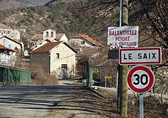
Le Saix
| miejscowość i gmina | |||
 | |||
| |||
| Państwo | |||
|---|---|---|---|
| Region | |||
| Departament | |||
| Okręg | |||
| Kod INSEE | 05158 | ||
| Powierzchnia | 21,33 km² | ||
| Populacja (1990) • liczba ludności |
| ||
| • gęstość | 3 os./km² | ||
| Kod pocztowy | 05400 | ||
| Portal | |||
Saix – miejscowość i gmina we Francji, w regionie Prowansja-Alpy-Lazurowe Wybrzeże, w departamencie Alpy Wysokie.
Według danych na rok 1990 gminę zamieszkiwały 64 osoby, a gęstość zaludnienia wynosiła 3 osoby/km² (wśród 963 gmin regionu Prowansja-Alpy-W. Lazurowe Saix plasuje się na 725. miejscu pod względem liczby ludności, natomiast pod względem powierzchni na miejscu 468.).
Bibliografia
- Francuski urząd statystyczny (fr.).
Media użyte na tej stronie
Autor: Superbenjamin, Licencja: CC BY-SA 4.0
Blank administrative map of France for geo-location purpose, with regions and departements distinguished. Approximate scale : 1:3,000,000
Autor: Flappiefh, Licencja: CC BY-SA 4.0
Blank administrative map of the region of Provence-Alpes-Côte d'Azur, France, for geo-location purpose.
Autor: Flappiefh, Licencja: CC BY-SA 4.0
Blank administrative map of the department of Hautes-Alpes, France, for geo-location purpose.
Autor: Fr.Latreille, Licencja: CC BY-SA 3.0
Le Saix (Hautes-Alpes), l'entrée du village sur la D49, venant de Chabestan. Vue vers l'Est. Le pont enjambe le torrent du Poutelier, venant du nord. Au milieu du village on voit le haut du mur de façade de l'église Saint-Vincent, avec ses deux cloches. En arrière-plan, les contreforts du Pibonnet (1267 m d'altitude, hors photo) surplombant la vallée du ruisseau de la Garenne.


