Legburthwaite
| ||
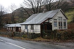
(c) Mick Garratt, CC BY-SA 2.0 | ||
| Państwo | ||
| Kraj | ||
| Hrabstwo | Kumbria | |
| Dystrykt | Allerdale | |
| Nr kierunkowy | 017687 | |
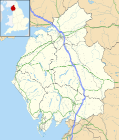
Położenie na mapie Kumbrii Contains Ordnance Survey data © Crown copyright and database right, CC BY-SA 3.0 | ||
Położenie na mapie Wielkiej Brytanii (c) Karte: NordNordWest, Lizenz: Creative Commons by-sa-3.0 de | ||
| Portal | ||
Legburthwaite – wieś w Anglii, w Kumbrii, w dystrykcie Allerdale. Leży 38 km na południe od miasta Carlisle i 392 km na północny zachód od Londynu[1].
Przypisy
- ↑ Legburthwaite na mapie (ang.). getamap.ordnancesurvey.co.uk. [dostęp 2010-11-27].
Media użyte na tej stronie
Contains Ordnance Survey data © Crown copyright and database right, CC BY-SA 3.0
Map of Cumbria, UK with the following information shown:
- Administrative borders
- Coastline, lakes and rivers
- Roads and railways
- Urban areas
Equirectangular map projection on WGS 84 datum, with N/S stretched 170%
Geographic limits:
- West: 3.80W
- East: 2.10W
- North: 55.20N
- South: 54.02N
(c) Karte: NordNordWest, Lizenz: Creative Commons by-sa-3.0 de
Location map of the United Kingdom
Flag of England. Saint George's cross (a red cross on a white background), used as the Flag of England, the Italian city of Genoa and various other places.
(c) Mick Garratt, CC BY-SA 2.0
Former Youth Hostel, Legburthwaite The former youth hostel closed in 2001. In April 2006 plans to demolish the building and to rebuild in stone and slate were refused Lake District planners. The Parish Council objected to the plans on the grounds the new 19 bed hostel "would be visually intrusive, there is no local need for the development, and on road safety issues". http://www.cwherald.com/archive/archive/hostel-%26%238220%3bwould-be-harmful-to-intimate-character-of-area%26%238221%3b-20060422230983.htm


