Leicestershire
| Hrabstwo ceremonialne i niemetropolitalne | |||||
 Wieża Old John Tower w parku Bradgate Park | |||||
| |||||
| Państwo | |||||
|---|---|---|---|---|---|
| Kraj | |||||
| Region | |||||
| Siedziba | Glenfield | ||||
| Powierzchnia | 2156 km² (cerem.) | ||||
| Populacja (2016) • liczba ludności |
| ||||
| • gęstość | 478 os./km² (cerem.) | ||||
| Szczegółowy podział administracyjny | |||||
 | |||||
| Liczba dystryktów | 7 | ||||
| Liczba unitary authorities | 1 | ||||
Położenie na mapie | |||||
| Strona internetowa | |||||
| Portal | |||||
Leicestershire (IPA: /ˈlɛstəʃɪər/ lub /ˈlɛstərʃər/ posłuchaj) – hrabstwo administracyjne (niemetropolitalne), ceremonialne i historyczne w środkowej Anglii, w regionie East Midlands.
Hrabstwo ceremonialne zajmuje powierzchnię 2156 km² i liczy 1 031 300 mieszkańców (2016)[1]. Największym miastem, jedynym posiadającym status city, oraz historyczną stolicą jest Leicester. Granice hrabstwa administracyjnego są tożsame z hrabstwem ceremonialnym z wyłączeniem Leicester, które stanowi osobną jednostkę administracyjną typu unitary authority. Powierzchnia hrabstwa administracyjnego wynosi 2083 km², a liczba ludności – 682 957 (2016)[1]. Ośrodkiem administracyjnym hrabstwa jest Glenfield. Główne miasta hrabstwa administracyjnego to Loughborough, Hinckley, Coalville, Melton Mowbray i Market Harborough[2].
Leicestershire jest hrabstwem nizinnym, przeciętym z południa na północ przez rzekę Soar. Nad nią skoncentrowana jest większa część ludności hrabstwa, w szczególności w jego środkowej części, w mieście Leicester i jego okolicach. Wschodnia część hrabstwa ma charakter wybitnie wiejski. W części północno-zachodniej znajduje się Charnwood Forest, obszar niskich wzgórz, częściowo zalesionych; jego krajobraz urozmaicony przez odsłonięte skały[3].
Na zachodzie Leicestershire graniczy z hrabstwem Warwickshire, na północnym zachodzie ze Staffordshire oraz Derbyshire, na północy z Nottinghamshire, na wschodzie z Lincolnshire i Rutland, a na południu z Northamptonshire[3].
Podział administracyjny
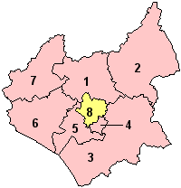
W skład hrabstwa wchodzi siedem dystryktów. Jako hrabstwo ceremonialne Leicestershire obejmuje dodatkowo jedną jednolitą jednostkę administracyjną (unitary authority).
- Charnwood
- Melton
- Harborough
- Oadby and Wigston
- Blaby
- Hinckley and Bosworth
- North West Leicestershire
- Leicester (unitary authority)
Mapa
Przypisy
- ↑ a b c d MYE5: Population estimates: Population density for the local authorities in the UK, mid-2001 to mid-2016, [w:] Population Estimates for UK, England and Wales, Scotland and Northern Ireland – Mid-2016 [online], Office for National Statistics [dostęp 2017-10-28] (ang.).
- ↑ a b Office for National Statistics: KS101EW - Usual resident population. [w:] 2011 Census [on-line]. Nomis – Official labour market statistics, 2013-02-12. [dostęp 2022-06-05]. (ang.).
- ↑ a b Leicestershire, [w:] Encyclopædia Britannica [online] [dostęp 2011-11-17] (ang.).
- ↑ Office for National Statistics: Built-up Area to Local Authority District (December 2011) Lookup in England and Wales. [w:] Open Geography Portal [on-line]. [dostęp 2022-06-05]. (ang.).
- ↑ Office for National Statistics: Built-up Area Sub Divisions (December 2011) Boundaries. [w:] Open Geography Potal [on-line]. [dostęp 2022-06-05]. (ang.).
Media użyte na tej stronie
Flag of England. Saint George's cross (a red cross on a white background), used as the Flag of England, the Italian city of Genoa and various other places.
The Armorial Banner of Leicestershire County Council [1] The flag is divided into four quarters. The first quarter is a cinquefol, or five within a red circle, the second quarter is charged a white lion with two tails on a red ground, the third quarter shows an ermine plume on a red ground and the fourth shows a black maunch.County Flag of Leicestershire
Autor: Nilfanion, Licencja: CC BY-SA 3.0
Location of the ceremonial county of Leicestershire within England.
Leicestershire pronunciation
Autor: Dannorcott, Licencja: CC BY-SA 3.0
Old John, a folly in Bradgate Park, Leicestershire
Contains Ordnance Survey data © Crown copyright and database right, CC BY-SA 3.0
Map of Leicestershire, UK with the following information shown:
- Administrative borders
- Coastline, lakes and rivers
- Roads and railways
- Urban areas
Equirectangular map projection on WGS 84 datum, with N/S stretched 160%
Geographic limits:
- West: 1.80W
- East: 0.50W
- North: 53.00N
- South: 52.36N


