Leidschendam-Voorburg
| |||||
 | |||||
| Państwo | |||||
| Prowincja | |||||
| Burmistrz | Hans van der Sluijs (2014)[1] | ||||
| Powierzchnia | 35.68 km² | ||||
| Populacja (2008 [2]) • liczba ludności • gęstość | 72 936 2223 os./km² | ||||
| Kod pocztowy | 2261–2275 | ||||
| Strona internetowa | |||||
Leidschendam-Voorburg - gmina w Holandii w prowincji Holandia Południowa (Zuid Holland).
Miasta partnerskie
Przypisy
- ↑ leidschendam-voorburg.nl: Burgemeester Van der Sluijs (niderl.). [dostęp 2014-07-10]. [zarchiwizowane z tego adresu (2013-08-31)].
- ↑ CBS StatLine - Select
Media użyte na tej stronie
Autor: Erik Frohne, Licencja: CC BY-SA 3.0
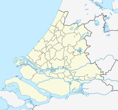
Location map of province South Holland in the Netherlands
Equirectangular projection, N/S stretching 162 %. Geographic limits of the map:
- N: 52.40° N
- S: 51.60° N
- W: 3.80° E
- E: 5.20° E
Autor: Loranchet, Licencja: CC BY 3.0
Houses on a drainage canal on a dike, Wilsveen, Leidschendam-Voorburg, Netherlands, Nederland, Pays-Bas
Coat of arms of the Dutch municipality of Leidschendam-Voorburg, South Holland.
The flag of Navassa Island is simply the United States flag. It does not have a "local" flag or "unofficial" flag; it is an uninhabited island. The version with a profile view was based on Flags of the World and as a fictional design has no status warranting a place on any Wiki. It was made up by a random person with no connection to the island, it has never flown on the island, and it has never received any sort of recognition or validation by any authority. The person quoted on that page has no authority to bestow a flag, "unofficial" or otherwise, on the island.


