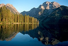
Leigh Lake
 jezioro Leigh Lake oraz szczyt Mount Moran | |
| Położenie | |
| Państwo | |
|---|---|
| Stan | |
| Lokalizacja | |
| Region | |
| Wysokość lustra | 2096 m n.p.m. |
| Wyspy | Mystic Isle |
| Morfometria | |
| Powierzchnia | 7,252 km² |
| Wymiary • max długość • max szerokość |
|
| Głębokość • średnia • maksymalna |
|
| Długość linii brzegowej | 12 km |
| Hydrologia | |
| Rodzaj jeziora | |
Leigh Lake - jezioro na terenie hrabstwa Teton w stanie Wyoming[1][2][3].
Geografia
Położenie
Zbiornik wodny znajduje się w paśmie Teton Range w Górach Skalistych. Od południa łączy się z mniejszym od niego jeziorem String Lake. Od wschodu znajdują się góry Mount Woodring, West Horn, Mount Moran oraz Rockchuck Peak, od północy jeziora Bearpaw Lake oraz Jackson Lake. Wokół całego jeziora znajdują się także małe i bezimienne zbiorniki[4].
Wyspy
| Nazwa | Długość brzegu | Najwyższy punkt |
|---|---|---|
| Mystic Isle | 1,45 km | 2101 m n.p.m. |
| Boulder Island | 0,75 km | 2102 m n.p.m. |
| bezimienne wyspy | 0,40 km | 2098 m n.p.m. |
Dopływy
Do jeziora dopływa strumień Leigh Creek oraz kilka bezimiennych cieków.
Turystyka
Na jeziorze można uprawiać kajakarstwo oraz wędkarstwo, nad zbiornikiem wodnym znajdują się także popularne miejsca na biwak[5][6].
Przypisy
- ↑ Leigh Lake - Hike to Leigh Lake in Grand Teton National Park, www.tetonhikingtrails.com [dostęp 2020-01-04].
- ↑ Leigh Lake (U.S. National Park Service), www.nps.gov [dostęp 2020-01-04] (ang.).
- ↑ CalTopo - Backcountry Mapping Evolved, caltopo.com [dostęp 2020-03-25].
- ↑ Leigh Lake, Natural Atlas [dostęp 2020-03-25] (ang.).
- ↑ Leigh Lake, Grand Teton National Park Fishing, Camping, Boating, AllTrips - Grand Teton National Park [dostęp 2020-01-04] (ang.).
- ↑ AllTrips.com, Leigh Lake, Grand Teton National Park Fishing, Camping, Boating, AllTrips - Grand Teton National Park [dostęp 2020-03-25] (ang.).
Media użyte na tej stronie
Autor: Uwe Dedering, Licencja: CC BY-SA 3.0
Relief location map of the USA (without Hawaii and Alaska).
EquiDistantConicProjection : Central parallel :
* N: 37.0° N
Central meridian :
* E: 96.0° W
Standard parallels:
* 1: 32.0° N
* 2: 42.0° N
Made with Natural Earth. Free vector and raster map data @ naturalearthdata.com.
Formulas for x and y:
x = 50.0 + 124.03149777329222 * ((1.9694462586094064-({{{2}}}* pi / 180))
      * sin(0.6010514667026994 * ({{{3}}} + 96) * pi / 180))
y = 50.0 + 1.6155950752393982 * 124.03149777329222 * 0.02613325650382181
      - 1.6155950752393982  * 124.03149777329222 *
     (1.3236744353715044  - (1.9694462586094064-({{{2}}}* pi / 180))
      * cos(0.6010514667026994 * ({{{3}}} + 96) * pi / 180))
The flag of Navassa Island is simply the United States flag. It does not have a "local" flag or "unofficial" flag; it is an uninhabited island. The version with a profile view was based on Flags of the World and as a fictional design has no status warranting a place on any Wiki. It was made up by a random person with no connection to the island, it has never flown on the island, and it has never received any sort of recognition or validation by any authority. The person quoted on that page has no authority to bestow a flag, "unofficial" or otherwise, on the island.
Autor: Tzugaj, Licencja: CC0
znak graficzny do map, ukazujący przykładowe jezioro
Leigh Lake and Mount Moran in Grand Teton National Park, Wyoming, USA
Autor: ikonact, Licencja: CC BY-SA 4.0
Relief location map of Wyoming, USA
Geographic limits of the map:
- N: 45.2° N
- S: 40.8° N
- W: 111.3° W
- E: 103.9° W


