Lexington (Michigan)
 Zdjęcie lotnicze wsi | |
| Państwo | |
|---|---|
| Stan | |
| Hrabstwo | |
| Powierzchnia | 3,65 km² |
| Wysokość | 188 m n.p.m. |
| Populacja (2010) • liczba ludności • gęstość |
|
| Nr kierunkowy | 810 |
| Kod pocztowy | 48450 |
Położenie na mapie Michigan  | |
Położenie na mapie Stanów Zjednoczonych  | |
| Portal | |
Lexington – wieś w hrabstwie Sanilac, w stanie Michigan, w Stanach Zjednoczonych. Według danych z 2010 roku Lexington zamieszkiwało ponad 1 tys. osób.
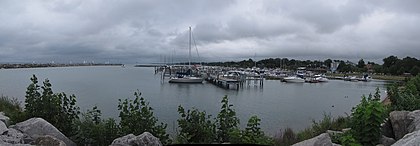
Port w Lexington
Skład etniczny
- Biali – 97,3%
- Afroamerykanie – 0,3%
- rdzenni Amerykanie – 0,2%
- Azjaci – 0,3%
- inne rasy – 0,7%
- pochodzenie mieszane – 1,3%
- Latynosi (każdej rasy) – 1,5%
Kontrola autorytatywna (wieś w Stanach Zjednoczonych):
Media użyte na tej stronie
USA Michigan location map.svg
Autor: Alexrk2, Licencja: CC BY 3.0
Ta mapa została stworzona za pomocą GeoTools.
Autor: Alexrk2, Licencja: CC BY 3.0
Ta mapa została stworzona za pomocą GeoTools.
Usa edcp location map.svg
Autor: Uwe Dedering, Licencja: CC BY-SA 3.0
Location map of the USA (without Hawaii and Alaska).
Autor: Uwe Dedering, Licencja: CC BY-SA 3.0
Location map of the USA (without Hawaii and Alaska).
EquiDistantConicProjection:
Central parallel:
* N: 37.0° N
Central meridian:
* E: 96.0° W
Standard parallels:
* 1: 32.0° N
* 2: 42.0° N
Made with Natural Earth. Free vector and raster map data @ naturalearthdata.com.
Formulas for x and y:
x = 50.0 + 124.03149777329222 * ((1.9694462586094064-({{{2}}}* pi / 180))
      * sin(0.6010514667026994 * ({{{3}}} + 96) * pi / 180))
y = 50.0 + 1.6155950752393982 * 124.03149777329222 * 0.02613325650382181
      - 1.6155950752393982  * 124.03149777329222 *
     (1.3236744353715044  - (1.9694462586094064-({{{2}}}* pi / 180))
      * cos(0.6010514667026994 * ({{{3}}} + 96) * pi / 180))

Flag of the United States.svg
The flag of Navassa Island is simply the United States flag. It does not have a "local" flag or "unofficial" flag; it is an uninhabited island. The version with a profile view was based on Flags of the World and as a fictional design has no status warranting a place on any Wiki. It was made up by a random person with no connection to the island, it has never flown on the island, and it has never received any sort of recognition or validation by any authority. The person quoted on that page has no authority to bestow a flag, "unofficial" or otherwise, on the island.
The flag of Navassa Island is simply the United States flag. It does not have a "local" flag or "unofficial" flag; it is an uninhabited island. The version with a profile view was based on Flags of the World and as a fictional design has no status warranting a place on any Wiki. It was made up by a random person with no connection to the island, it has never flown on the island, and it has never received any sort of recognition or validation by any authority. The person quoted on that page has no authority to bestow a flag, "unofficial" or otherwise, on the island.

Lexington Michigan aerial view.jpg
Aerial view of Lexington, Michigan, USA. The U.S. Army Corps of Engineers constructed the harbor and breakwater on Lake Huron.
Aerial view of Lexington, Michigan, USA. The U.S. Army Corps of Engineers constructed the harbor and breakwater on Lake Huron.

Lexington-MI-Harbor-01s.jpg
Autor: Traveler100, Licencja: CC BY-SA 3.0
en:Lexington, Michigan State Harbor
Autor: Traveler100, Licencja: CC BY-SA 3.0
en:Lexington, Michigan State Harbor