Lichfield (dystrykt)
| dystrykt niemetropolitalny | |
(c) Dave Napier, CC BY-SA 2.0 Lichfield | |
| Państwo | |
|---|---|
| Kraj | |
| Region | |
| Hrabstwo | |
| Siedziba | |
| Powierzchnia | 331,3 km² |
| Populacja (2011) • liczba ludności |
|
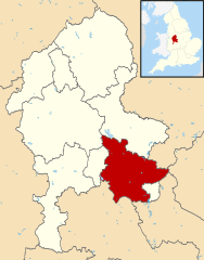
Położenie na mapie Staffordshire | |
| Strona internetowa | |
| Portal | |
Lichfield – dystrykt w hrabstwie Staffordshire w Anglii. W 2011 roku dystrykt liczył 100 654 mieszkańców[1].
Miasta
Inne miejscowości
Alrewas, Armitage, Barton Turn, Blithbury, Chasetown, Clifton Campville, Colton, Comberford, Croxall, Drayton Bassett, Edial, Edingale, Elford, Elmhurst, Fradley, Gentleshaw, Hammerwich, Hamstall Ridware, Handsacre, Harlaston, Haselour, Haunton, Hill Ridware, Hints, Hopwas, Ingestre, King’s Bromley, Longdon, Mavesyn Ridware, Shenstone, Statfold, Stonnall, Streethay, Swinfen, Syerscote, Thorpe Constantine, Upper Longdon, Wall, Weeford, Weston, Whittington, Wigginton.
Przypisy
- ↑ Area: Lichfield (Local Authority) (ang.). Neighbourhood Statistics (ONS). [dostęp 2016-04-29]. [zarchiwizowane z tego adresu (2016-10-06)].
Media użyte na tej stronie
Flag of England. Saint George's cross (a red cross on a white background), used as the Flag of England, the Italian city of Genoa and various other places.
(c) Dave Napier, CC BY-SA 2.0
West front of Lichfield Cathedral, Staffordshire, England
Autor:
- Staffordshire UK district map (blank).svg: Nilfanion, created using Ordnance Survey data
- derivative work: Renly (talk)
Map of Staffordshire, with Lichfield highlighted.


