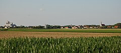
Lichtenwörth
 | |||
| |||
| Państwo | |||
|---|---|---|---|
| Kraj związkowy | |||
| Powiat | Wiener Neustadt-Land | ||
| Powierzchnia | 22,97 km² | ||
| Wysokość | 254 m n.p.m. | ||
| Populacja (1 stycznia 2014) • liczba ludności | 2 804 | ||
| • gęstość | 122 os./km² | ||
| Numer kierunkowy | 02622 | ||
| Kod pocztowy | 2493, 2700, 2702 | ||
| Tablice rejestracyjne | WB | ||
| Strona internetowa | |||
Lichtenwörth – gmina targowa w Austrii, w kraju związkowym Dolna Austria, w powiecie Wiener Neustadt-Land. Według Austriackiego Urzędu Statystycznego liczyła 2 804 mieszkańców (1 stycznia 2014)[1].
Przypisy
Media użyte na tej stronie
Autor: Rosso Robot, Licencja: CC BY-SA 3.0
Location map of Lower Austria
Equirectangular projection. Geographic limits of the map:
- N: 49.02796° N
- S: 47.38301° N
- W: 14.44565° E
- E: 17.07430° E
Autor: Lencer, Licencja: CC BY-SA 3.0
Location map of Austria
Equirectangular projection, N/S stretching 150 %. Geographic limits of the map:
- N: 49.2° N
- S: 46.3° N
- W: 9.4° E
- E: 17.2° E
Autor: Wolfgang Glock, Licencja: CC BY 3.0
View of Lichtenwörth (Lower Austria) from south. Near the left edge of the image there is the Herzig flour mill, right of centre dome and spires of St. Theresa church at Nadelburg, near the right edge the spire of St. Jacob parish church.


