Linia M metra w Nowym Jorku
| ||||||||||||||||||||||||||||||||||||||||||||||||||||||||||||||||||||||||||||||||||||||||||||||||||||||||||||||||||||||||||||||||||||||||||||||||||||||||||||||||||||||||||||||||||||||||||||||||||||||||||||||||||||||||||||||||||||||||||||||||||||||||||||||||||||||||||||||||||||||||||||||||||||||||||||||||||||||||||||||||||||||||||||||||||||||||||||||||||||||||||||||||||||||||||||||||||||||||||||||||||||||||||||||||||||||||||||||||||||||||||||||||||||||||||||||||||||||||||||||||||||||||||||||||||||||||||||||||||||||||||||||
 | ||||||||||||||||||||||||||||||||||||||||||||||||||||||||||||||||||||||||||||||||||||||||||||||||||||||||||||||||||||||||||||||||||||||||||||||||||||||||||||||||||||||||||||||||||||||||||||||||||||||||||||||||||||||||||||||||||||||||||||||||||||||||||||||||||||||||||||||||||||||||||||||||||||||||||||||||||||||||||||||||||||||||||||||||||||||||||||||||||||||||||||||||||||||||||||||||||||||||||||||||||||||||||||||||||||||||||||||||||||||||||||||||||||||||||||||||||||||||||||||||||||||||||||||||||||||||||||||||||||||||||||||
| Dane podstawowe | ||||||||||||||||||||||||||||||||||||||||||||||||||||||||||||||||||||||||||||||||||||||||||||||||||||||||||||||||||||||||||||||||||||||||||||||||||||||||||||||||||||||||||||||||||||||||||||||||||||||||||||||||||||||||||||||||||||||||||||||||||||||||||||||||||||||||||||||||||||||||||||||||||||||||||||||||||||||||||||||||||||||||||||||||||||||||||||||||||||||||||||||||||||||||||||||||||||||||||||||||||||||||||||||||||||||||||||||||||||||||||||||||||||||||||||||||||||||||||||||||||||||||||||||||||||||||||||||||||||||||||||||
| Zarządca | Metropolitan Transportation Authority | |||||||||||||||||||||||||||||||||||||||||||||||||||||||||||||||||||||||||||||||||||||||||||||||||||||||||||||||||||||||||||||||||||||||||||||||||||||||||||||||||||||||||||||||||||||||||||||||||||||||||||||||||||||||||||||||||||||||||||||||||||||||||||||||||||||||||||||||||||||||||||||||||||||||||||||||||||||||||||||||||||||||||||||||||||||||||||||||||||||||||||||||||||||||||||||||||||||||||||||||||||||||||||||||||||||||||||||||||||||||||||||||||||||||||||||||||||||||||||||||||||||||||||||||||||||||||||||||||||||||||||||
| Oznaczenie linii | M | |||||||||||||||||||||||||||||||||||||||||||||||||||||||||||||||||||||||||||||||||||||||||||||||||||||||||||||||||||||||||||||||||||||||||||||||||||||||||||||||||||||||||||||||||||||||||||||||||||||||||||||||||||||||||||||||||||||||||||||||||||||||||||||||||||||||||||||||||||||||||||||||||||||||||||||||||||||||||||||||||||||||||||||||||||||||||||||||||||||||||||||||||||||||||||||||||||||||||||||||||||||||||||||||||||||||||||||||||||||||||||||||||||||||||||||||||||||||||||||||||||||||||||||||||||||||||||||||||||||||||||||
| Rozstaw szyn | 1435 mm | |||||||||||||||||||||||||||||||||||||||||||||||||||||||||||||||||||||||||||||||||||||||||||||||||||||||||||||||||||||||||||||||||||||||||||||||||||||||||||||||||||||||||||||||||||||||||||||||||||||||||||||||||||||||||||||||||||||||||||||||||||||||||||||||||||||||||||||||||||||||||||||||||||||||||||||||||||||||||||||||||||||||||||||||||||||||||||||||||||||||||||||||||||||||||||||||||||||||||||||||||||||||||||||||||||||||||||||||||||||||||||||||||||||||||||||||||||||||||||||||||||||||||||||||||||||||||||||||||||||||||||||
 Pociąg linii M jadący po trasie BMT Jamaica Line w kierunku stacji Hewes Street na Brooklynie. | ||||||||||||||||||||||||||||||||||||||||||||||||||||||||||||||||||||||||||||||||||||||||||||||||||||||||||||||||||||||||||||||||||||||||||||||||||||||||||||||||||||||||||||||||||||||||||||||||||||||||||||||||||||||||||||||||||||||||||||||||||||||||||||||||||||||||||||||||||||||||||||||||||||||||||||||||||||||||||||||||||||||||||||||||||||||||||||||||||||||||||||||||||||||||||||||||||||||||||||||||||||||||||||||||||||||||||||||||||||||||||||||||||||||||||||||||||||||||||||||||||||||||||||||||||||||||||||||||||||||||||||||
| ||||||||||||||||||||||||||||||||||||||||||||||||||||||||||||||||||||||||||||||||||||||||||||||||||||||||||||||||||||||||||||||||||||||||||||||||||||||||||||||||||||||||||||||||||||||||||||||||||||||||||||||||||||||||||||||||||||||||||||||||||||||||||||||||||||||||||||||||||||||||||||||||||||||||||||||||||||||||||||||||||||||||||||||||||||||||||||||||||||||||||||||||||||||||||||||||||||||||||||||||||||||||||||||||||||||||||||||||||||||||||||||||||||||||||||||||||||||||||||||||||||||||||||||||||||||||||||||||||||||||||||||
| Portal | ||||||||||||||||||||||||||||||||||||||||||||||||||||||||||||||||||||||||||||||||||||||||||||||||||||||||||||||||||||||||||||||||||||||||||||||||||||||||||||||||||||||||||||||||||||||||||||||||||||||||||||||||||||||||||||||||||||||||||||||||||||||||||||||||||||||||||||||||||||||||||||||||||||||||||||||||||||||||||||||||||||||||||||||||||||||||||||||||||||||||||||||||||||||||||||||||||||||||||||||||||||||||||||||||||||||||||||||||||||||||||||||||||||||||||||||||||||||||||||||||||||||||||||||||||||||||||||||||||||||||||||||
Linia M – linia metra nowojorskiego. Jest oznaczona kolorem pomarańczowym na znakach stacji, znakach trasy oraz na oficjalnych mapach metra. Na swym przebiegu przez Manhattan nosi nazwę IND Sixth Avenue Line[1].
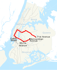
Linia M kursuje przez cały czas. W dni powszednie linia M działa między Forest Hills – 71st Avenue w Queens i Middle Village – Metropolitan Avenue w Queens, przez Queens Boulevard, Sixth Avenue, i Williamsburg Bridge. Późną nocą i weekendy M działa jako linia wahadłowa na BMT Myrtle Avenue Line między Metropolitan Avenue i Myrtle Avenue w Brooklynie.
Przypisy
- ↑ mta.info | Line Colors, web.mta.info [dostęp 2017-11-15] (ang.).
Linki zewnętrzne
Media użyte na tej stronie
underground train station (legend icon)
ex underground train station (legend icon)
underground train stop (legend icon)
ex underground train stop (legend icon)
underground service station (legend icon)
ex underground service station (legend icon)
non-passenger stop (legend icon)
ex non-passenger stop (legend icon)
underground service stop (legend icon)
ex underground service stop (legend icon)
local-only minor station
Icons for railway description
out-of-use local-only minor metro station
Railroad BSicon
Underground straight track
ex underground straight track
straight line, modified version (+ex, +t, +ext)
underground tunnel straight track
ex underground tunnel straight track
high level track
ex high level track
underground high level track
ex underground high level track
Bridge (big)
Bridge (big)
BS template transport icon
bridge over water straight (big)
bridge over water straight (big)
for BS models. water tunnel, urban(blue), not in use.
mileage change
ex mileage change
A mile-marker for metros/canals
mileage change
Border icon
Track change (new design)
track change (new design)
Track switch, metro/light rail
track change, metro/light rail (new design)
level crossing straight
Disused railway line level crossing on minor road.
underground level crossing straight
Ex underground level crossing straight
Autor: Lekko gazowany, Licencja: CC BY-SA 3.0
electrified line start sign for railways
Autor: Lekko gazowany, Licencja: CC BY-SA 3.0
electrified line end sign for railways
underground stop
rail icon
underground tunnel stop
This is a map showing the New York City Subway's M service. It was created with TIGER/Line GIS data (water and boundaries) and my own data (subway lines and stations, traced on TIGER/Line road data). If you would like a copy of the subway data, email me.
icon for parallel railways
Icons for railway description. Due to recent server disturbance this image may be displaying the old version.
Underground tunnel terminal station
rail icon
Continuation backward, rotated across, set "u"
Bullet for New York City Subway M service
railway icon
rail icon
Autor: user:axpde, Licencja: CC BY-SA 3.0 de
underground crossing tunnel / tunnel across
light railway end of elevated track
Continuation in tunnel forward, rotated across, set "u"
rail icon
close parallel metro/light rail lines; station on left line
underground ex tunnel terminal stop
see en:Wikipedia:Route diagram template
elevated continuation
Parallel lines in tunnel: track + station, set "u"
Icon for BS railway description
underground tunnel station
Underground station
double subway lines (on surface) with crossing subway line (in tunnel)
Autor: Adam E. Moreira, Licencja: CC BY-SA 3.0
R160 M train is about to enter Hewes Street, bound for Middle Village.
Icons for railway description. Due to recent server disturbance this image may be displaying the old version.
BS template transport icon
light rail turning loop end to the right
ex underground stop
underground tower station overhead, track across
Symbol: Tram
Underground tunnel tower station, tunnel across


