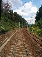
Linia kolejowa Mosty u Jablunkova - Bohumín
Linia kolejowa Mosty u Jablunkova - Bohumín – linia kolejowa w południowej części kraju morawsko-śląskiego. Linia kolejowa na całej długości jest dwutorowa i zelektryfikowana.
Historia
Linia kolejowa poprowadzona od Bogumina przez Orłowę do Cieszyna została otwarta 1 lutego 1869 roku. Kolejny odcinek linii kolejowej poprowadzony do Żyliny został otwarty 8 stycznia 1871 roku. W grudniu przedłużono ją do Koszyc, a tak powstałą linię nazwano koleją koszycko-bogumińską. Na odcinku zbudowano pod Przełęczą Jabłonkowską tunel o długości ponad 600 metrów. Linia kolejowa w późniejszym okresie została przebudowana na odcinek dwutorowy. Od 30 września 1915 roku funkcjonowała całkowicie jako szlak dwutorowy. W latach 60. XX wieku przebieg linii kolejowej został zmieniony, omijając Orłową i wybierając zaś szlak na północ przez Lutynię Dolną i Dziećmorowice. Zlikwidowano także dworzec w Karwinie i okoliczne przystanki oraz wybudowano nowoczesny dworzec Karviná hlavní nádraži, dodatkowo linia kolejowa w 1964 roku została zelektryfikowana. W 2007 roku została rozpoczęta modernizacja odcinka z Bystrzycy do granicy czesko-słowackiej w Mostach koło Jabłonkowa wraz z przebudową tunelu pod Przełęczą Jabłonkowską. W 2009 roku została rozpoczęta modernizacja odcinka od Bystrzycy do Czeskiego Cieszyna zakończona w 2013 roku. Linia kolejowa jest elementem III korytarza tranzytowego kolei czeskich o prędkości maksymalnej 160 km/h[1].
Przypisy
- ↑ Koleje Śląska Cieszyńskiego: Opis i historia linii 301A.
Media użyte na tej stronie
underground train station (legend icon)
ex underground train station (legend icon)
underground train stop (legend icon)
ex underground train stop (legend icon)
underground service station (legend icon)
ex underground service station (legend icon)
non-passenger stop (legend icon)
ex non-passenger stop (legend icon)
underground service stop (legend icon)
ex underground service stop (legend icon)
local-only minor station
Icons for railway description
out-of-use local-only minor metro station
Railroad BSicon
Underground straight track
ex underground straight track
straight line, modified version (+ex, +t, +ext)
underground tunnel straight track
ex underground tunnel straight track
high level track
ex high level track
underground high level track
ex underground high level track
Bridge (big)
Bridge (big)
BS template transport icon
bridge over water straight (big)
bridge over water straight (big)
for BS models. water tunnel, urban(blue), not in use.
mileage change
ex mileage change
A mile-marker for metros/canals
mileage change
Border icon
Track change (new design)
track change (new design)
Track switch, metro/light rail
track change, metro/light rail (new design)
level crossing straight
Disused railway line level crossing on minor road.
underground level crossing straight
Ex underground level crossing straight
Autor: Lekko gazowany, Licencja: CC BY-SA 3.0
electrified line start sign for railways
Autor: Lekko gazowany, Licencja: CC BY-SA 3.0
electrified line end sign for railways
flag stop track straight in use
station straight track
track to right against driving direction (with exact circles)
crossing underneath
Track to left forward driving direction (with exact circles)
junction straight to the left and right (with exact circles)
track to left against driving direction (with exact circles)
Ex flag stop, track straight in use
Track through with 3rd corner
Autor: Matej Grochal, Licencja: CC BY-SA 4.0
Košice-Bohumín Railway near Dolní Lomná, Czechia in August 2018.
Interrupted line between regular positions at 2nd and 4th corners
Track with border on bridge over water
Interrupted line between regular positions at 1st and 3rd corners
Mask for line fading backward, rotated across
junction aqross and to the left
flying junction, straight and from the upper right (4th quadrant)
flying junction, straight and to the lower right (3rd quadrant)
track change, corner 1st quadrant
Autor:
- Treti_zeleznicni_koridor.svg: Honza Groh
- Czechia_-_outline_map.svg: Caroig
- derivative work: Olos88 (talk)
Map of third train coridor in the Czech republic


