Linia kolejowa nr 353
| Poznań Wschód – Skandawa | |||||||||||||||||||||||||||||||||||||||||||||||||||||||||||||||||||||||||||||||||||||||||||||||||||||||||||||||||||||||||||||||||||||||||||||||||||||||||||||||||||||||||||||||||||||||||||||||||||||||||||||||||||||||||||||||||||||||||||||||||||||||||||||||||||||||||||||||||||||||||||||||||||||||||||||||||||||||||||||||||||||||||||||||||||||||||||||||||||||||||||||||||||||||||||||||||||||||||||||||||||||||||||||||||||||||||||||||||||||||||||||||||||||||||||||||||||||||||||||||||||||||||||||||||||||||||||||||||||||||||||||||||||||||||||||||||||||||||||||||||||||||||||||||||||||||||||||||||||||||||||||||||||||||||||||||||||||||||||||||||||||||||||||||||||||||||||||||||||||||||||||||||||||||||||||||||||||||||||||||||||||||||||||||||||||||||||||||||||||||||||||||||||||||||||||||||||||||||||||||||||||||||||||||||||||||||||||||||||||||||||||||||||||||||||||||||||||||||||||||||||||||||||||||||||||||||||||||||||||||||||||||||||||||||||||||||||||||||||||||||||||||||||||||||||||||||||||||||||||||
 | |||||||||||||||||||||||||||||||||||||||||||||||||||||||||||||||||||||||||||||||||||||||||||||||||||||||||||||||||||||||||||||||||||||||||||||||||||||||||||||||||||||||||||||||||||||||||||||||||||||||||||||||||||||||||||||||||||||||||||||||||||||||||||||||||||||||||||||||||||||||||||||||||||||||||||||||||||||||||||||||||||||||||||||||||||||||||||||||||||||||||||||||||||||||||||||||||||||||||||||||||||||||||||||||||||||||||||||||||||||||||||||||||||||||||||||||||||||||||||||||||||||||||||||||||||||||||||||||||||||||||||||||||||||||||||||||||||||||||||||||||||||||||||||||||||||||||||||||||||||||||||||||||||||||||||||||||||||||||||||||||||||||||||||||||||||||||||||||||||||||||||||||||||||||||||||||||||||||||||||||||||||||||||||||||||||||||||||||||||||||||||||||||||||||||||||||||||||||||||||||||||||||||||||||||||||||||||||||||||||||||||||||||||||||||||||||||||||||||||||||||||||||||||||||||||||||||||||||||||||||||||||||||||||||||||||||||||||||||||||||||||||||||||||||||||||||||||||||||||||||
| Dane podstawowe | |||||||||||||||||||||||||||||||||||||||||||||||||||||||||||||||||||||||||||||||||||||||||||||||||||||||||||||||||||||||||||||||||||||||||||||||||||||||||||||||||||||||||||||||||||||||||||||||||||||||||||||||||||||||||||||||||||||||||||||||||||||||||||||||||||||||||||||||||||||||||||||||||||||||||||||||||||||||||||||||||||||||||||||||||||||||||||||||||||||||||||||||||||||||||||||||||||||||||||||||||||||||||||||||||||||||||||||||||||||||||||||||||||||||||||||||||||||||||||||||||||||||||||||||||||||||||||||||||||||||||||||||||||||||||||||||||||||||||||||||||||||||||||||||||||||||||||||||||||||||||||||||||||||||||||||||||||||||||||||||||||||||||||||||||||||||||||||||||||||||||||||||||||||||||||||||||||||||||||||||||||||||||||||||||||||||||||||||||||||||||||||||||||||||||||||||||||||||||||||||||||||||||||||||||||||||||||||||||||||||||||||||||||||||||||||||||||||||||||||||||||||||||||||||||||||||||||||||||||||||||||||||||||||||||||||||||||||||||||||||||||||||||||||||||||||||||||||||||||||||
| Zarządca | |||||||||||||||||||||||||||||||||||||||||||||||||||||||||||||||||||||||||||||||||||||||||||||||||||||||||||||||||||||||||||||||||||||||||||||||||||||||||||||||||||||||||||||||||||||||||||||||||||||||||||||||||||||||||||||||||||||||||||||||||||||||||||||||||||||||||||||||||||||||||||||||||||||||||||||||||||||||||||||||||||||||||||||||||||||||||||||||||||||||||||||||||||||||||||||||||||||||||||||||||||||||||||||||||||||||||||||||||||||||||||||||||||||||||||||||||||||||||||||||||||||||||||||||||||||||||||||||||||||||||||||||||||||||||||||||||||||||||||||||||||||||||||||||||||||||||||||||||||||||||||||||||||||||||||||||||||||||||||||||||||||||||||||||||||||||||||||||||||||||||||||||||||||||||||||||||||||||||||||||||||||||||||||||||||||||||||||||||||||||||||||||||||||||||||||||||||||||||||||||||||||||||||||||||||||||||||||||||||||||||||||||||||||||||||||||||||||||||||||||||||||||||||||||||||||||||||||||||||||||||||||||||||||||||||||||||||||||||||||||||||||||||||||||||||||||||||||||||||||||
|---|---|---|---|---|---|---|---|---|---|---|---|---|---|---|---|---|---|---|---|---|---|---|---|---|---|---|---|---|---|---|---|---|---|---|---|---|---|---|---|---|---|---|---|---|---|---|---|---|---|---|---|---|---|---|---|---|---|---|---|---|---|---|---|---|---|---|---|---|---|---|---|---|---|---|---|---|---|---|---|---|---|---|---|---|---|---|---|---|---|---|---|---|---|---|---|---|---|---|---|---|---|---|---|---|---|---|---|---|---|---|---|---|---|---|---|---|---|---|---|---|---|---|---|---|---|---|---|---|---|---|---|---|---|---|---|---|---|---|---|---|---|---|---|---|---|---|---|---|---|---|---|---|---|---|---|---|---|---|---|---|---|---|---|---|---|---|---|---|---|---|---|---|---|---|---|---|---|---|---|---|---|---|---|---|---|---|---|---|---|---|---|---|---|---|---|---|---|---|---|---|---|---|---|---|---|---|---|---|---|---|---|---|---|---|---|---|---|---|---|---|---|---|---|---|---|---|---|---|---|---|---|---|---|---|---|---|---|---|---|---|---|---|---|---|---|---|---|---|---|---|---|---|---|---|---|---|---|---|---|---|---|---|---|---|---|---|---|---|---|---|---|---|---|---|---|---|---|---|---|---|---|---|---|---|---|---|---|---|---|---|---|---|---|---|---|---|---|---|---|---|---|---|---|---|---|---|---|---|---|---|---|---|---|---|---|---|---|---|---|---|---|---|---|---|---|---|---|---|---|---|---|---|---|---|---|---|---|---|---|---|---|---|---|---|---|---|---|---|---|---|---|---|---|---|---|---|---|---|---|---|---|---|---|---|---|---|---|---|---|---|---|---|---|---|---|---|---|---|---|---|---|---|---|---|---|---|---|---|---|---|---|---|---|---|---|---|---|---|---|---|---|---|---|---|---|---|---|---|---|---|---|---|---|---|---|---|---|---|---|---|---|---|---|---|---|---|---|---|---|---|---|---|---|---|---|---|---|---|---|---|---|---|---|---|---|---|---|---|---|---|---|---|---|---|---|---|---|---|---|---|---|---|---|---|---|---|---|---|---|---|---|---|---|---|---|---|---|---|---|---|---|---|---|---|---|---|---|---|---|---|---|---|---|---|---|---|---|---|---|---|---|---|---|---|---|---|---|---|---|---|---|---|---|---|---|---|---|---|---|---|---|---|---|---|---|---|---|---|---|---|---|---|---|---|---|---|---|---|---|---|---|---|---|---|---|---|---|---|---|---|---|---|---|---|---|---|---|---|---|---|---|---|---|---|---|---|---|---|---|---|---|---|---|---|---|---|---|---|---|---|---|---|---|---|---|---|---|---|---|---|---|---|---|---|---|---|---|---|---|---|---|---|---|---|---|---|---|---|---|---|---|---|---|---|---|---|---|---|---|---|---|---|---|---|---|---|---|---|---|---|---|---|---|---|---|---|---|---|---|---|---|---|---|---|---|---|---|---|---|---|---|---|---|---|---|---|---|---|---|---|---|---|---|---|---|---|---|---|---|---|---|---|---|---|---|---|---|---|---|---|---|---|---|---|---|---|---|---|---|---|---|---|---|---|---|---|---|---|---|---|---|---|---|---|---|---|---|---|---|---|---|---|---|---|---|---|---|---|---|---|---|---|---|---|---|---|---|---|---|---|---|---|---|---|---|---|---|---|---|---|---|---|---|---|---|---|---|---|---|---|---|---|---|---|---|---|---|---|---|---|---|---|---|---|---|---|---|---|---|---|---|---|---|---|---|---|---|---|---|---|---|---|---|---|---|---|---|---|---|---|---|---|---|---|---|---|---|---|---|---|---|---|---|---|---|---|---|---|---|---|---|---|---|---|---|---|---|---|---|---|---|---|---|---|---|---|---|---|---|---|---|---|---|---|---|---|---|---|---|---|---|---|---|---|---|---|---|---|---|---|---|---|---|---|---|---|---|---|---|---|---|---|---|---|---|---|---|---|---|---|---|---|---|---|---|---|---|---|---|---|---|---|---|---|---|---|---|---|---|---|---|---|---|---|---|---|---|---|---|---|---|---|---|---|---|---|---|---|---|---|---|---|---|---|---|---|---|---|---|---|---|---|---|---|---|---|---|---|---|---|---|---|---|---|---|---|---|---|---|---|---|---|---|---|---|---|---|---|---|---|---|---|---|---|---|---|---|---|---|---|---|---|---|---|---|---|---|---|---|---|---|---|---|---|---|---|---|---|---|---|---|---|---|---|---|---|---|---|---|---|---|---|---|---|---|---|---|---|---|
| Numer linii | 353 | ||||||||||||||||||||||||||||||||||||||||||||||||||||||||||||||||||||||||||||||||||||||||||||||||||||||||||||||||||||||||||||||||||||||||||||||||||||||||||||||||||||||||||||||||||||||||||||||||||||||||||||||||||||||||||||||||||||||||||||||||||||||||||||||||||||||||||||||||||||||||||||||||||||||||||||||||||||||||||||||||||||||||||||||||||||||||||||||||||||||||||||||||||||||||||||||||||||||||||||||||||||||||||||||||||||||||||||||||||||||||||||||||||||||||||||||||||||||||||||||||||||||||||||||||||||||||||||||||||||||||||||||||||||||||||||||||||||||||||||||||||||||||||||||||||||||||||||||||||||||||||||||||||||||||||||||||||||||||||||||||||||||||||||||||||||||||||||||||||||||||||||||||||||||||||||||||||||||||||||||||||||||||||||||||||||||||||||||||||||||||||||||||||||||||||||||||||||||||||||||||||||||||||||||||||||||||||||||||||||||||||||||||||||||||||||||||||||||||||||||||||||||||||||||||||||||||||||||||||||||||||||||||||||||||||||||||||||||||||||||||||||||||||||||||||||||||||||||||||||||
| Tabela SRJP | 430 | ||||||||||||||||||||||||||||||||||||||||||||||||||||||||||||||||||||||||||||||||||||||||||||||||||||||||||||||||||||||||||||||||||||||||||||||||||||||||||||||||||||||||||||||||||||||||||||||||||||||||||||||||||||||||||||||||||||||||||||||||||||||||||||||||||||||||||||||||||||||||||||||||||||||||||||||||||||||||||||||||||||||||||||||||||||||||||||||||||||||||||||||||||||||||||||||||||||||||||||||||||||||||||||||||||||||||||||||||||||||||||||||||||||||||||||||||||||||||||||||||||||||||||||||||||||||||||||||||||||||||||||||||||||||||||||||||||||||||||||||||||||||||||||||||||||||||||||||||||||||||||||||||||||||||||||||||||||||||||||||||||||||||||||||||||||||||||||||||||||||||||||||||||||||||||||||||||||||||||||||||||||||||||||||||||||||||||||||||||||||||||||||||||||||||||||||||||||||||||||||||||||||||||||||||||||||||||||||||||||||||||||||||||||||||||||||||||||||||||||||||||||||||||||||||||||||||||||||||||||||||||||||||||||||||||||||||||||||||||||||||||||||||||||||||||||||||||||||||||||||
| Długość | 389,975 km | ||||||||||||||||||||||||||||||||||||||||||||||||||||||||||||||||||||||||||||||||||||||||||||||||||||||||||||||||||||||||||||||||||||||||||||||||||||||||||||||||||||||||||||||||||||||||||||||||||||||||||||||||||||||||||||||||||||||||||||||||||||||||||||||||||||||||||||||||||||||||||||||||||||||||||||||||||||||||||||||||||||||||||||||||||||||||||||||||||||||||||||||||||||||||||||||||||||||||||||||||||||||||||||||||||||||||||||||||||||||||||||||||||||||||||||||||||||||||||||||||||||||||||||||||||||||||||||||||||||||||||||||||||||||||||||||||||||||||||||||||||||||||||||||||||||||||||||||||||||||||||||||||||||||||||||||||||||||||||||||||||||||||||||||||||||||||||||||||||||||||||||||||||||||||||||||||||||||||||||||||||||||||||||||||||||||||||||||||||||||||||||||||||||||||||||||||||||||||||||||||||||||||||||||||||||||||||||||||||||||||||||||||||||||||||||||||||||||||||||||||||||||||||||||||||||||||||||||||||||||||||||||||||||||||||||||||||||||||||||||||||||||||||||||||||||||||||||||||||||||
| Rozstaw szyn | 1435 mm | ||||||||||||||||||||||||||||||||||||||||||||||||||||||||||||||||||||||||||||||||||||||||||||||||||||||||||||||||||||||||||||||||||||||||||||||||||||||||||||||||||||||||||||||||||||||||||||||||||||||||||||||||||||||||||||||||||||||||||||||||||||||||||||||||||||||||||||||||||||||||||||||||||||||||||||||||||||||||||||||||||||||||||||||||||||||||||||||||||||||||||||||||||||||||||||||||||||||||||||||||||||||||||||||||||||||||||||||||||||||||||||||||||||||||||||||||||||||||||||||||||||||||||||||||||||||||||||||||||||||||||||||||||||||||||||||||||||||||||||||||||||||||||||||||||||||||||||||||||||||||||||||||||||||||||||||||||||||||||||||||||||||||||||||||||||||||||||||||||||||||||||||||||||||||||||||||||||||||||||||||||||||||||||||||||||||||||||||||||||||||||||||||||||||||||||||||||||||||||||||||||||||||||||||||||||||||||||||||||||||||||||||||||||||||||||||||||||||||||||||||||||||||||||||||||||||||||||||||||||||||||||||||||||||||||||||||||||||||||||||||||||||||||||||||||||||||||||||||||||||
| Sieć trakcyjna | 3000 V DC na odcinku Poznań Wschód – Korsze | ||||||||||||||||||||||||||||||||||||||||||||||||||||||||||||||||||||||||||||||||||||||||||||||||||||||||||||||||||||||||||||||||||||||||||||||||||||||||||||||||||||||||||||||||||||||||||||||||||||||||||||||||||||||||||||||||||||||||||||||||||||||||||||||||||||||||||||||||||||||||||||||||||||||||||||||||||||||||||||||||||||||||||||||||||||||||||||||||||||||||||||||||||||||||||||||||||||||||||||||||||||||||||||||||||||||||||||||||||||||||||||||||||||||||||||||||||||||||||||||||||||||||||||||||||||||||||||||||||||||||||||||||||||||||||||||||||||||||||||||||||||||||||||||||||||||||||||||||||||||||||||||||||||||||||||||||||||||||||||||||||||||||||||||||||||||||||||||||||||||||||||||||||||||||||||||||||||||||||||||||||||||||||||||||||||||||||||||||||||||||||||||||||||||||||||||||||||||||||||||||||||||||||||||||||||||||||||||||||||||||||||||||||||||||||||||||||||||||||||||||||||||||||||||||||||||||||||||||||||||||||||||||||||||||||||||||||||||||||||||||||||||||||||||||||||||||||||||||||||||
| Prędkość maksymalna | 160[1] km/h | ||||||||||||||||||||||||||||||||||||||||||||||||||||||||||||||||||||||||||||||||||||||||||||||||||||||||||||||||||||||||||||||||||||||||||||||||||||||||||||||||||||||||||||||||||||||||||||||||||||||||||||||||||||||||||||||||||||||||||||||||||||||||||||||||||||||||||||||||||||||||||||||||||||||||||||||||||||||||||||||||||||||||||||||||||||||||||||||||||||||||||||||||||||||||||||||||||||||||||||||||||||||||||||||||||||||||||||||||||||||||||||||||||||||||||||||||||||||||||||||||||||||||||||||||||||||||||||||||||||||||||||||||||||||||||||||||||||||||||||||||||||||||||||||||||||||||||||||||||||||||||||||||||||||||||||||||||||||||||||||||||||||||||||||||||||||||||||||||||||||||||||||||||||||||||||||||||||||||||||||||||||||||||||||||||||||||||||||||||||||||||||||||||||||||||||||||||||||||||||||||||||||||||||||||||||||||||||||||||||||||||||||||||||||||||||||||||||||||||||||||||||||||||||||||||||||||||||||||||||||||||||||||||||||||||||||||||||||||||||||||||||||||||||||||||||||||||||||||||||||
.jpg) Linia kolejowa nr 353 w Lednogórze | |||||||||||||||||||||||||||||||||||||||||||||||||||||||||||||||||||||||||||||||||||||||||||||||||||||||||||||||||||||||||||||||||||||||||||||||||||||||||||||||||||||||||||||||||||||||||||||||||||||||||||||||||||||||||||||||||||||||||||||||||||||||||||||||||||||||||||||||||||||||||||||||||||||||||||||||||||||||||||||||||||||||||||||||||||||||||||||||||||||||||||||||||||||||||||||||||||||||||||||||||||||||||||||||||||||||||||||||||||||||||||||||||||||||||||||||||||||||||||||||||||||||||||||||||||||||||||||||||||||||||||||||||||||||||||||||||||||||||||||||||||||||||||||||||||||||||||||||||||||||||||||||||||||||||||||||||||||||||||||||||||||||||||||||||||||||||||||||||||||||||||||||||||||||||||||||||||||||||||||||||||||||||||||||||||||||||||||||||||||||||||||||||||||||||||||||||||||||||||||||||||||||||||||||||||||||||||||||||||||||||||||||||||||||||||||||||||||||||||||||||||||||||||||||||||||||||||||||||||||||||||||||||||||||||||||||||||||||||||||||||||||||||||||||||||||||||||||||||||||||
| Historia | |||||||||||||||||||||||||||||||||||||||||||||||||||||||||||||||||||||||||||||||||||||||||||||||||||||||||||||||||||||||||||||||||||||||||||||||||||||||||||||||||||||||||||||||||||||||||||||||||||||||||||||||||||||||||||||||||||||||||||||||||||||||||||||||||||||||||||||||||||||||||||||||||||||||||||||||||||||||||||||||||||||||||||||||||||||||||||||||||||||||||||||||||||||||||||||||||||||||||||||||||||||||||||||||||||||||||||||||||||||||||||||||||||||||||||||||||||||||||||||||||||||||||||||||||||||||||||||||||||||||||||||||||||||||||||||||||||||||||||||||||||||||||||||||||||||||||||||||||||||||||||||||||||||||||||||||||||||||||||||||||||||||||||||||||||||||||||||||||||||||||||||||||||||||||||||||||||||||||||||||||||||||||||||||||||||||||||||||||||||||||||||||||||||||||||||||||||||||||||||||||||||||||||||||||||||||||||||||||||||||||||||||||||||||||||||||||||||||||||||||||||||||||||||||||||||||||||||||||||||||||||||||||||||||||||||||||||||||||||||||||||||||||||||||||||||||||||||||||||||||
| Rok otwarcia | 1871 | ||||||||||||||||||||||||||||||||||||||||||||||||||||||||||||||||||||||||||||||||||||||||||||||||||||||||||||||||||||||||||||||||||||||||||||||||||||||||||||||||||||||||||||||||||||||||||||||||||||||||||||||||||||||||||||||||||||||||||||||||||||||||||||||||||||||||||||||||||||||||||||||||||||||||||||||||||||||||||||||||||||||||||||||||||||||||||||||||||||||||||||||||||||||||||||||||||||||||||||||||||||||||||||||||||||||||||||||||||||||||||||||||||||||||||||||||||||||||||||||||||||||||||||||||||||||||||||||||||||||||||||||||||||||||||||||||||||||||||||||||||||||||||||||||||||||||||||||||||||||||||||||||||||||||||||||||||||||||||||||||||||||||||||||||||||||||||||||||||||||||||||||||||||||||||||||||||||||||||||||||||||||||||||||||||||||||||||||||||||||||||||||||||||||||||||||||||||||||||||||||||||||||||||||||||||||||||||||||||||||||||||||||||||||||||||||||||||||||||||||||||||||||||||||||||||||||||||||||||||||||||||||||||||||||||||||||||||||||||||||||||||||||||||||||||||||||||||||||||||||
| Rok włączenia do PKP | 1920 (na odcinku Poznań Wschód - Jamielnik) | ||||||||||||||||||||||||||||||||||||||||||||||||||||||||||||||||||||||||||||||||||||||||||||||||||||||||||||||||||||||||||||||||||||||||||||||||||||||||||||||||||||||||||||||||||||||||||||||||||||||||||||||||||||||||||||||||||||||||||||||||||||||||||||||||||||||||||||||||||||||||||||||||||||||||||||||||||||||||||||||||||||||||||||||||||||||||||||||||||||||||||||||||||||||||||||||||||||||||||||||||||||||||||||||||||||||||||||||||||||||||||||||||||||||||||||||||||||||||||||||||||||||||||||||||||||||||||||||||||||||||||||||||||||||||||||||||||||||||||||||||||||||||||||||||||||||||||||||||||||||||||||||||||||||||||||||||||||||||||||||||||||||||||||||||||||||||||||||||||||||||||||||||||||||||||||||||||||||||||||||||||||||||||||||||||||||||||||||||||||||||||||||||||||||||||||||||||||||||||||||||||||||||||||||||||||||||||||||||||||||||||||||||||||||||||||||||||||||||||||||||||||||||||||||||||||||||||||||||||||||||||||||||||||||||||||||||||||||||||||||||||||||||||||||||||||||||||||||||||||||
| Rok elektryfikacji | 1976 - 1990 (na odcinku Poznań Wschód - Korsze) | ||||||||||||||||||||||||||||||||||||||||||||||||||||||||||||||||||||||||||||||||||||||||||||||||||||||||||||||||||||||||||||||||||||||||||||||||||||||||||||||||||||||||||||||||||||||||||||||||||||||||||||||||||||||||||||||||||||||||||||||||||||||||||||||||||||||||||||||||||||||||||||||||||||||||||||||||||||||||||||||||||||||||||||||||||||||||||||||||||||||||||||||||||||||||||||||||||||||||||||||||||||||||||||||||||||||||||||||||||||||||||||||||||||||||||||||||||||||||||||||||||||||||||||||||||||||||||||||||||||||||||||||||||||||||||||||||||||||||||||||||||||||||||||||||||||||||||||||||||||||||||||||||||||||||||||||||||||||||||||||||||||||||||||||||||||||||||||||||||||||||||||||||||||||||||||||||||||||||||||||||||||||||||||||||||||||||||||||||||||||||||||||||||||||||||||||||||||||||||||||||||||||||||||||||||||||||||||||||||||||||||||||||||||||||||||||||||||||||||||||||||||||||||||||||||||||||||||||||||||||||||||||||||||||||||||||||||||||||||||||||||||||||||||||||||||||||||||||||||||||
| Rok zawieszenia ruchu | 2000 (na odcinku Korsze - Żeleznodorożnyj) | ||||||||||||||||||||||||||||||||||||||||||||||||||||||||||||||||||||||||||||||||||||||||||||||||||||||||||||||||||||||||||||||||||||||||||||||||||||||||||||||||||||||||||||||||||||||||||||||||||||||||||||||||||||||||||||||||||||||||||||||||||||||||||||||||||||||||||||||||||||||||||||||||||||||||||||||||||||||||||||||||||||||||||||||||||||||||||||||||||||||||||||||||||||||||||||||||||||||||||||||||||||||||||||||||||||||||||||||||||||||||||||||||||||||||||||||||||||||||||||||||||||||||||||||||||||||||||||||||||||||||||||||||||||||||||||||||||||||||||||||||||||||||||||||||||||||||||||||||||||||||||||||||||||||||||||||||||||||||||||||||||||||||||||||||||||||||||||||||||||||||||||||||||||||||||||||||||||||||||||||||||||||||||||||||||||||||||||||||||||||||||||||||||||||||||||||||||||||||||||||||||||||||||||||||||||||||||||||||||||||||||||||||||||||||||||||||||||||||||||||||||||||||||||||||||||||||||||||||||||||||||||||||||||||||||||||||||||||||||||||||||||||||||||||||||||||||||||||||||||||
| |||||||||||||||||||||||||||||||||||||||||||||||||||||||||||||||||||||||||||||||||||||||||||||||||||||||||||||||||||||||||||||||||||||||||||||||||||||||||||||||||||||||||||||||||||||||||||||||||||||||||||||||||||||||||||||||||||||||||||||||||||||||||||||||||||||||||||||||||||||||||||||||||||||||||||||||||||||||||||||||||||||||||||||||||||||||||||||||||||||||||||||||||||||||||||||||||||||||||||||||||||||||||||||||||||||||||||||||||||||||||||||||||||||||||||||||||||||||||||||||||||||||||||||||||||||||||||||||||||||||||||||||||||||||||||||||||||||||||||||||||||||||||||||||||||||||||||||||||||||||||||||||||||||||||||||||||||||||||||||||||||||||||||||||||||||||||||||||||||||||||||||||||||||||||||||||||||||||||||||||||||||||||||||||||||||||||||||||||||||||||||||||||||||||||||||||||||||||||||||||||||||||||||||||||||||||||||||||||||||||||||||||||||||||||||||||||||||||||||||||||||||||||||||||||||||||||||||||||||||||||||||||||||||||||||||||||||||||||||||||||||||||||||||||||||||||||||||||||||||||
| Portal | |||||||||||||||||||||||||||||||||||||||||||||||||||||||||||||||||||||||||||||||||||||||||||||||||||||||||||||||||||||||||||||||||||||||||||||||||||||||||||||||||||||||||||||||||||||||||||||||||||||||||||||||||||||||||||||||||||||||||||||||||||||||||||||||||||||||||||||||||||||||||||||||||||||||||||||||||||||||||||||||||||||||||||||||||||||||||||||||||||||||||||||||||||||||||||||||||||||||||||||||||||||||||||||||||||||||||||||||||||||||||||||||||||||||||||||||||||||||||||||||||||||||||||||||||||||||||||||||||||||||||||||||||||||||||||||||||||||||||||||||||||||||||||||||||||||||||||||||||||||||||||||||||||||||||||||||||||||||||||||||||||||||||||||||||||||||||||||||||||||||||||||||||||||||||||||||||||||||||||||||||||||||||||||||||||||||||||||||||||||||||||||||||||||||||||||||||||||||||||||||||||||||||||||||||||||||||||||||||||||||||||||||||||||||||||||||||||||||||||||||||||||||||||||||||||||||||||||||||||||||||||||||||||||||||||||||||||||||||||||||||||||||||||||||||||||||||||||||||||||||
Linia kolejowa nr 353 Poznań Wschód – Skandawa – linia kolejowa przebiegająca przez województwa wielkopolskie, kujawsko-pomorskie i warmińsko-mazurskie.
Charakterystyka
| Liczba torów | Elektryfikacja | Przeznaczenie linii |
|---|---|---|
|
|
|
Historia
- 20 listopada 1871 – otwarcie linii Toruń Wschodni – Jabłonowo Pomorskie – 2 tory
- 27 grudnia 1871 – otwarcie linii Czerwonka – Żeleznodorożnyj – 2 tory
- 26 maja 1872 – otwarcie linii Poznań Wschód – Inowrocław – 1 tor
- 1 grudnia 1872 – otwarcie linii Jabłonowo Pomorskie – Ostróda – 2 tory
- 1 grudnia 1872 – otwarcie linii Olsztyn Główny – Czerwonka – 2 tory
- 25 marca 1873 – otwarcie linii Inowrocław – Toruń Główny – 2 tory
- 15 sierpnia 1873 – otwarcie linii Toruń Główny – Toruń Wschodni – 2 tory
- 15 sierpnia 1873 – otwarcie linii Ostróda – Olsztyn Główny – 2 tory
- 1 stycznia 1886 – zmiana liczby torów na odcinku Poznań Wschód – Toruń Główny – 2 tory
- 1 stycznia 1945 – zmiana liczby torów na odcinku Korsze – Żeleznodorożnyj – 1 tor
- 23 grudnia 1976 – elektryfikacja odcinka Poznań Wschód – Inowrocław
- 20 grudnia 1983 – elektryfikacja odcinka Inowrocław – Toruń Główny
- 16 października 1986 – elektryfikacja odcinka Toruń Wschodni – Iława Główna
- 13 grudnia 1987 – elektryfikacja odcinka Toruń Główny – Toruń Wschodni
- 3 października 1988 – elektryfikacja odcinka Iława Główna – Olsztyn Główny
- 18 grudnia 1990 – elektryfikacja odcinka Olsztyn Główny – Korsze
- 12 marca 2000 – zamknięcie dla ruchu pasażerskiego odcinka Skandawa – Żeleznodorożnyj
- 3 kwietnia 2000 – zamknięcie dla ruchu pasażerskiego odcinka Korsze – Skandawa[2]
- 3 października 2016 – PKP Polskie Linie Kolejowe podpisały z ZUE umowę na modernizację fragmentu linii 353 na odcinku Ostrowite – Biskupiec Pomorski oraz Biskupiec Pomorski – Jamielnik[3]
- czerwiec 2017 – PKP Polskie Linie Kolejowe podpisały umowę na modernizację fragmentu linii 353 na odcinku Jamielnik – Olsztyn[4]
- 2020 – PKP PLK zamówiło studium wykonalności modernizacji linii wraz z budową nowej linii od Górowa do Kętrzyna na linii nr 259[5].
Galeria
 (c) Adam Kliczek / Wikipedia, CC BY-SA 3.0
Wipsowo, województwo warmińsko-mazurskie
dawny przystanek kolejowy w Parysie pod Korszami (województwo warmińsko-mazurskie)
Przypisy
- ↑ Wykaz maksymalnych prędkości – pociągi pasażerskie, www.plk-sa.pl.
- ↑ Linia kolejowa nr 353 w Ogólnopolskiej Bazie Kolejowej – bazakolejowa.pl
- ↑ ZUE z umową na modernizację linii 353. rynek-kolejowy.pl, 2016-10-06. [dostęp 2016-10-08].
- ↑ Szybciej koleją z Iławy do Olsztyna. rynekkurierkolejowy.eu, 2017-06-26. [dostęp 2017-08-09].
- ↑ PLK zamawia studium linii 353 Iława–Olsztyn–Korsze – granica. Będzie nowy odcinek do Kętrzyna?, www.rynek-kolejowy.pl [dostęp 2020-02-10] (pol.).
Media użyte na tej stronie


BSicon ulBHF.svg
underground train station (legend icon)
underground train station (legend icon)

BSicon uexlBHF.svg
ex underground train station (legend icon)
ex underground train station (legend icon)


BSicon ulHST.svg
underground train stop (legend icon)
underground train stop (legend icon)

BSicon uexlHST.svg
ex underground train stop (legend icon)
ex underground train stop (legend icon)


BSicon ulDST.svg
underground service station (legend icon)
underground service station (legend icon)

BSicon uexlDST.svg
ex underground service station (legend icon)
ex underground service station (legend icon)

BSicon lBST.svg
non-passenger stop (legend icon)
non-passenger stop (legend icon)

BSicon exlBST.svg
ex non-passenger stop (legend icon)
ex non-passenger stop (legend icon)

BSicon ulBST.svg
underground service stop (legend icon)
underground service stop (legend icon)

BSicon uexlBST.svg
ex underground service stop (legend icon)
ex underground service stop (legend icon)


BSicon expHST.svg
local-only minor station
local-only minor station

BSicon upHST.svg
Icons for railway description
Icons for railway description

BSicon uexpHST.svg
out-of-use local-only minor metro station
out-of-use local-only minor metro station


BSicon uexENDEe.svg
Railroad BSicon
Railroad BSicon


BSicon uSTR.svg
Underground straight track
Underground straight track

BSicon uexSTR.svg
ex underground straight track
ex underground straight track


BSicon extSTR.svg
straight line, modified version (+ex, +t, +ext)
straight line, modified version (+ex, +t, +ext)

BSicon utSTR.svg
underground tunnel straight track
underground tunnel straight track

BSicon uextSTR.svg
ex underground tunnel straight track
ex underground tunnel straight track

BSicon hSTR.svg
high level track
high level track

BSicon exhSTR.svg
ex high level track
ex high level track

BSicon uhSTR.svg
underground high level track
underground high level track

BSicon uexhSTR.svg
ex underground high level track
ex underground high level track

BSicon hSTRae.svg
Bridge (big)
Bridge (big)

BSicon exhSTRae.svg
Bridge (big)
Bridge (big)


BSicon uexhSTRae.svg
BS template transport icon
BS template transport icon

BSicon hKRZWae.svg
bridge over water straight (big)
bridge over water straight (big)

BSicon exhKRZWae.svg
bridge over water straight (big)
bridge over water straight (big)


BSicon uexKRZWu.svg
for BS models. water tunnel, urban(blue), not in use.
for BS models. water tunnel, urban(blue), not in use.

BSicon KMW.svg
mileage change
mileage change

BSicon exKMW.svg
ex mileage change
ex mileage change

BSicon uKMW.svg
A mile-marker for metros/canals
A mile-marker for metros/canals

BSicon uexKMW.svg
mileage change
mileage change


BSicon exSTR+GRZq.svg
Border icon
Border icon

BSicon ÜST.svg
Track change (new design)
Track change (new design)

BSicon exÜST.svg
track change (new design)
track change (new design)

BSicon uÜST.svg
Track switch, metro/light rail
Track switch, metro/light rail

BSicon uexÜST.svg
track change, metro/light rail (new design)
track change, metro/light rail (new design)

BSicon BUE.svg
level crossing straight
level crossing straight

BSicon exSKRZ-YBUE.svg
Disused railway line level crossing on minor road.
Disused railway line level crossing on minor road.

BSicon uBUE.svg
underground level crossing straight
underground level crossing straight

BSicon uexBUE.svg
Ex underground level crossing straight
Ex underground level crossing straight


BSicon ELCa.svg
Autor: Lekko gazowany, Licencja: CC BY-SA 3.0
electrified line start sign for railways
Autor: Lekko gazowany, Licencja: CC BY-SA 3.0
electrified line start sign for railways


BSicon ELCe.svg
Autor: Lekko gazowany, Licencja: CC BY-SA 3.0
electrified line end sign for railways
Autor: Lekko gazowany, Licencja: CC BY-SA 3.0
electrified line end sign for railways


BSicon BHF-L.svg
Station right
Station right

BSicon HST.svg
flag stop track straight in use
flag stop track straight in use


BSicon BHF.svg
station straight track
station straight track


BSicon WBRÜCKE2.svg
bridge over water straight (small)
bridge over water straight (small)

BSicon BST.svg
non-passenger stop track straight in use
non-passenger stop track straight in use


BSicon STR+l.svg
track to right against driving direction (with exact circles)
track to right against driving direction (with exact circles)

BSicon eBST.svg
ex non-passenger stop track straight in use
ex non-passenger stop track straight in use

BSicon STRl.svg
Track to left forward driving direction (with exact circles)
Track to left forward driving direction (with exact circles)


BSicon DST.svg
non-passenger station track straight in use
non-passenger station track straight in use


BSicon exSTR+r.svg
ex-track to left against driving direction (with exact circles)
ex-track to left against driving direction (with exact circles)


BSicon exSTRr.svg
ex-track to right forward driving direction (with exact circles)
ex-track to right forward driving direction (with exact circles)

BSicon exSTR+l.svg
ex-track to right against driving direction (with exact circles)
ex-track to right against driving direction (with exact circles)


BSicon exDST.svg
ex non-passenger station track straight off use
ex non-passenger station track straight off use


BSicon exLSTRl.svg
BSicon
BSicon

BSicon exKBHFa-L.svg
BSicon
BSicon
Lednogóra, przystanek kolejowy, 2018-07-15 (05).jpg
Autor: Nostrix, Licencja: CC BY-SA 4.0
Przystanek Lednogóra, linia kolejowa nr 353, kierunek Gniezno
Autor: Nostrix, Licencja: CC BY-SA 4.0
Przystanek Lednogóra, linia kolejowa nr 353, kierunek Gniezno

BSicon LSTR+l.svg
BSicon
BSicon
.jpg)
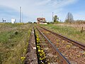
1 Dawny przystanek kolejowy w Parysie (gmina Korsze).jpg
Autor: Sankoff64, Licencja: CC BY-SA 4.0
Dawny przystanek kolejowy w Parysie (gmina Korsze), zamknięty dla ruchu pasażerskiego w 2000 roku. Linia kolejowa nr 353.
Autor: Sankoff64, Licencja: CC BY-SA 4.0
Dawny przystanek kolejowy w Parysie (gmina Korsze), zamknięty dla ruchu pasażerskiego w 2000 roku. Linia kolejowa nr 353.


BSicon exBHF-L.svg
Station right (closed)
Station right (closed)

Wipsowo, dworzec 01.jpg
(c) Adam Kliczek / Wikipedia, CC BY-SA 3.0
Przystanek kolejowy w Wipsowie na linii kolejowej nr 353, w województwie warmińsko-mazurskim, w powiecie olsztyńskim, w Polsce.
(c) Adam Kliczek / Wikipedia, CC BY-SA 3.0
Przystanek kolejowy w Wipsowie na linii kolejowej nr 353, w województwie warmińsko-mazurskim, w powiecie olsztyńskim, w Polsce.

BSicon DST-M.svg
Autor:
Icon between File:BSicon DSTl2.svg and File:BSicon DSTr2.svg
Autor:
- BSicon_DSTr2.svg: Wiebevl
- derivative work: Miraceti (talk)
Icon between File:BSicon DSTl2.svg and File:BSicon DSTr2.svg

BSicon eKRZo.svg
ex crossing overhead
ex crossing overhead

BSicon KDSTa-L.svg
Autor: Deonyi, Licencja: CC BY-SA 3.0
Left hand non-passenger station interchange
Autor: Deonyi, Licencja: CC BY-SA 3.0
Left hand non-passenger station interchange

BSicon KRZo.svg
Crossing overhead
Crossing overhead

Most kolejowy im. Ernesta Malinowskiego.jpg
Autor: Mateuszgdynia, Licencja: CC BY-SA 4.0
Most kolejowy im. Ernesta Malinowskiego
Autor: Mateuszgdynia, Licencja: CC BY-SA 4.0
Most kolejowy im. Ernesta Malinowskiego


BSicon LABZqr.svg
A combination of (
( (
(
A combination of
LSTRq) line and ABZqr) junction. In Finnish Wikipedia LUECKE-style lines means continues to joining line. 


BSicon eBHF-R.svg
spoorsjabloon
spoorsjabloon


BSicon exLSTR+l.svg
BSicon
BSicon

BSicon tSTRl.svg
Tunnel track to left forward driving directing (with exact circles)
Tunnel track to left forward driving directing (with exact circles)

BSicon exLSTR+r.svg
BSicon
BSicon

Stacja Janikowo Dolne 2018.jpg
Autor: Klapi, Licencja: CC BY 4.0
Stacja kolejowa Jankowo Dolne koło Gniezna, Wielkopolska, Polska
Autor: Klapi, Licencja: CC BY 4.0
Stacja kolejowa Jankowo Dolne koło Gniezna, Wielkopolska, Polska

.jpg)
Wąbrzeźno, przejazd kolejowy (LK 353).jpg
Autor: Gdaniec, Licencja: CC BY-SA 3.0
Wąbrzeźno|, przejazd kolejowy (LK 353)
Autor: Gdaniec, Licencja: CC BY-SA 3.0
Wąbrzeźno|, przejazd kolejowy (LK 353)

BSicon LSTRl.svg
BSicon
BSicon


BSicon STRr.svg
track to right forward driving direction (with exact circles)
track to right forward driving direction (with exact circles)

BSicon LSTRr.svg
BSicon
BSicon

BSicon KBHFe-L.svg
Rail icon
Rail icon

BSicon STR+r.svg
track to left against driving direction (with exact circles)
track to left against driving direction (with exact circles)


BSicon exKBHFe-L.svg
Stations and stops
Stations and stops

BSicon LSTR+r.svg
BSicon
BSicon


BSicon KBHFxe-R.svg
BS: xKopfbahnhof (Ende)
BS: xKopfbahnhof (Ende)


BSicon KRZu.svg
crossing underneath
crossing underneath

BSicon STR+GRZq.svg
Autor: de:User:Bernina, de:User:axpde, Licencja: CC BY-SA 3.0 de
track with ex border
Autor: de:User:Bernina, de:User:axpde, Licencja: CC BY-SA 3.0 de
track with ex border

BSicon BHF-R.svg
Station left
Station left
POL rail 353 map.png
Autor: Marcinekk2, Licencja: CC BY-SA 3.0
Linia kolejowa nr 353 Poznań Wschód – Skandawa – (Żeleznodorożnyj)
Autor: Marcinekk2, Licencja: CC BY-SA 3.0
Linia kolejowa nr 353 Poznań Wschód – Skandawa – (Żeleznodorożnyj)


BSicon eKRZu.svg
ex crossing underneath
ex crossing underneath

BSicon xKRZo.svg
Ex crossing overhead
Ex crossing overhead


BSicon ABZlr.svg
junction to left & right
junction to left & right

BSicon exLSTRr.svg
Icon for railway line description
Icon for railway line description

BSicon exBHF-R.svg
station, out-of-use, left connection
station, out-of-use, left connection
