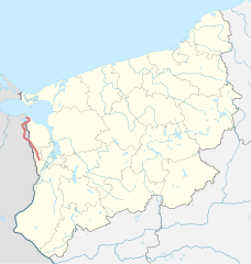
Linia kolejowa nr 429
| Stobno Szczecińskie – Nowe Warpno | ||||||||||||||||||||||||||||||||||||||||||||||||||||||||||||||||||||||||||||||||||||||||||||||||||||||||||||||||||||||||||||||||||||||||||||||||||||||||||||||||||||||||||||||||||||||||||||||||||||||||||||||||||||||||||||||||||||||||||||||||||||||||||||||||||||||||||||
 | ||||||||||||||||||||||||||||||||||||||||||||||||||||||||||||||||||||||||||||||||||||||||||||||||||||||||||||||||||||||||||||||||||||||||||||||||||||||||||||||||||||||||||||||||||||||||||||||||||||||||||||||||||||||||||||||||||||||||||||||||||||||||||||||||||||||||||||
| Dane podstawowe | ||||||||||||||||||||||||||||||||||||||||||||||||||||||||||||||||||||||||||||||||||||||||||||||||||||||||||||||||||||||||||||||||||||||||||||||||||||||||||||||||||||||||||||||||||||||||||||||||||||||||||||||||||||||||||||||||||||||||||||||||||||||||||||||||||||||||||||
| Numer linii | 429 | |||||||||||||||||||||||||||||||||||||||||||||||||||||||||||||||||||||||||||||||||||||||||||||||||||||||||||||||||||||||||||||||||||||||||||||||||||||||||||||||||||||||||||||||||||||||||||||||||||||||||||||||||||||||||||||||||||||||||||||||||||||||||||||||||||||||||||
|---|---|---|---|---|---|---|---|---|---|---|---|---|---|---|---|---|---|---|---|---|---|---|---|---|---|---|---|---|---|---|---|---|---|---|---|---|---|---|---|---|---|---|---|---|---|---|---|---|---|---|---|---|---|---|---|---|---|---|---|---|---|---|---|---|---|---|---|---|---|---|---|---|---|---|---|---|---|---|---|---|---|---|---|---|---|---|---|---|---|---|---|---|---|---|---|---|---|---|---|---|---|---|---|---|---|---|---|---|---|---|---|---|---|---|---|---|---|---|---|---|---|---|---|---|---|---|---|---|---|---|---|---|---|---|---|---|---|---|---|---|---|---|---|---|---|---|---|---|---|---|---|---|---|---|---|---|---|---|---|---|---|---|---|---|---|---|---|---|---|---|---|---|---|---|---|---|---|---|---|---|---|---|---|---|---|---|---|---|---|---|---|---|---|---|---|---|---|---|---|---|---|---|---|---|---|---|---|---|---|---|---|---|---|---|---|---|---|---|---|---|---|---|---|---|---|---|---|---|---|---|---|---|---|---|---|---|---|---|---|---|---|---|---|---|---|---|---|---|---|---|---|---|---|---|---|---|---|---|---|---|---|---|---|---|---|---|---|---|
| Długość | 48,7[1] km | |||||||||||||||||||||||||||||||||||||||||||||||||||||||||||||||||||||||||||||||||||||||||||||||||||||||||||||||||||||||||||||||||||||||||||||||||||||||||||||||||||||||||||||||||||||||||||||||||||||||||||||||||||||||||||||||||||||||||||||||||||||||||||||||||||||||||||
| Rozstaw szyn | 1435 mm | |||||||||||||||||||||||||||||||||||||||||||||||||||||||||||||||||||||||||||||||||||||||||||||||||||||||||||||||||||||||||||||||||||||||||||||||||||||||||||||||||||||||||||||||||||||||||||||||||||||||||||||||||||||||||||||||||||||||||||||||||||||||||||||||||||||||||||
| Historia | ||||||||||||||||||||||||||||||||||||||||||||||||||||||||||||||||||||||||||||||||||||||||||||||||||||||||||||||||||||||||||||||||||||||||||||||||||||||||||||||||||||||||||||||||||||||||||||||||||||||||||||||||||||||||||||||||||||||||||||||||||||||||||||||||||||||||||||
| Lata budowy | 1897–1906[1] | |||||||||||||||||||||||||||||||||||||||||||||||||||||||||||||||||||||||||||||||||||||||||||||||||||||||||||||||||||||||||||||||||||||||||||||||||||||||||||||||||||||||||||||||||||||||||||||||||||||||||||||||||||||||||||||||||||||||||||||||||||||||||||||||||||||||||||
| ||||||||||||||||||||||||||||||||||||||||||||||||||||||||||||||||||||||||||||||||||||||||||||||||||||||||||||||||||||||||||||||||||||||||||||||||||||||||||||||||||||||||||||||||||||||||||||||||||||||||||||||||||||||||||||||||||||||||||||||||||||||||||||||||||||||||||||
| Portal | ||||||||||||||||||||||||||||||||||||||||||||||||||||||||||||||||||||||||||||||||||||||||||||||||||||||||||||||||||||||||||||||||||||||||||||||||||||||||||||||||||||||||||||||||||||||||||||||||||||||||||||||||||||||||||||||||||||||||||||||||||||||||||||||||||||||||||||
Linia kolejowa nr 429 (do 1945 r. Randower Kleinbahn) – nieistniejąca (częściowo rozebrana); łącząca stację Stobno Szczecińskie ze stacją Nowe Warpno.
Przypisy
- ↑ a b Andrzej Kotula: Koleją podróż sentymentalna. sedina.pl, 2005-11-18. [dostęp 2019-05-16].
Linki zewnętrzne
- Linia kolejowa nr 429 w Ogólnopolskiej Bazie Kolejowej – bazakolejowa.pl
Media użyte na tej stronie
underground train station (legend icon)
ex underground train station (legend icon)
underground train stop (legend icon)
ex underground train stop (legend icon)
underground service station (legend icon)
ex underground service station (legend icon)
non-passenger stop (legend icon)
ex non-passenger stop (legend icon)
underground service stop (legend icon)
ex underground service stop (legend icon)
local-only minor station
Icons for railway description
out-of-use local-only minor metro station
Railroad BSicon
Underground straight track
ex underground straight track
straight line, modified version (+ex, +t, +ext)
underground tunnel straight track
ex underground tunnel straight track
high level track
ex high level track
underground high level track
ex underground high level track
Bridge (big)
Bridge (big)
BS template transport icon
bridge over water straight (big)
bridge over water straight (big)
for BS models. water tunnel, urban(blue), not in use.
mileage change
ex mileage change
A mile-marker for metros/canals
mileage change
Border icon
Track change (new design)
track change (new design)
Track switch, metro/light rail
track change, metro/light rail (new design)
level crossing straight
Disused railway line level crossing on minor road.
underground level crossing straight
Ex underground level crossing straight
Autor: Lekko gazowany, Licencja: CC BY-SA 3.0
electrified line start sign for railways
Autor: Lekko gazowany, Licencja: CC BY-SA 3.0
electrified line end sign for railways
Mask for line fading backward
station straight track
Straight line aqross (according to naming convention, name + modifier)
Autor: Szczecinolog, Licencja: CC BY-SA 4.0
Mapa zlikwidowanej linii kolejowej nr 429
ex terminal station, track ending
Ex crossing
ex flag stop track straight off use
Mask for line fading backward, rotated across
Straight line aqross (according to naming convention, name + modifier)
ex station straight track
Mask for line fading forward, rotated across
