Lista ciał planetarnych w Układzie Słonecznym
| Ten artykuł należy dopracować |
Lista ciał planetarnych w Układzie Słonecznym, zawiera wszystkie znane planety, planety karłowate oraz satelity rozmiarów planetarnych[a][1]. Pozwala to na gromadzenie danych o ciałach wielkości planet w Układzie Słonecznym i ich charakterystyce, koncentrując się na specyficznych ciałach ważnych dla możliwej kolonizacji Układu Słonecznego. Dla tych obiektów, dla których dostępne są odpowiednie dane, zamieszczono też schematy budowy wewnętrznej. Ciała pogrupowane są w układy planeta-księżyc i podzielone na główne strefy Układu Słonecznego. Satelity są uszeregowane według odległości od macierzystej planety.
| Legenda | |||||
|---|---|---|---|---|---|
| Planeta | Satelita | Planeta karłowata | |||
| Region | Nazwa | Typ | Zdjęcie | Wnętrze | Średnica [km] | Przyspieszenie grawitacyjne na powierzchni [m/s²] | Prędkość ucieczki [km/s] | Dzień słoneczny [h][b] | Powierzchnia [km²×106] | Powierzchnia (suma układu)[c] |
|---|---|---|---|---|---|---|---|---|---|---|
| P L A N E T Y S K A L I S T E | Merkury | planeta |  |  | 4878 | 3,70 | 4,2 | 4223 | 75 | 75 |
| Wenus | planeta |  |  | 12104 | 8,9 | 10,4 | 2802 | 460 | 460 | |
| Ziemia | planeta |  | 12756 | 9,8 | 11,2 | 24 | 510,1 | 548 | ||
| Księżyc | satelita |  |  | 3476 | 1,62 | 2,4 | 731 | 37,9 | ||
| Mars | planeta |  |  | 6786 | 3,72 | 5,0 | 25 | 144,8 | 144,8 | |
| Ceres | planeta karłowata |  | 950 | 0,26 | 0,5 | 9 | 2,8 | 2,8 | ||
| G A Z O W E O L B R Z Y M Y | Jowisz | planeta |  | 142700 | 24,9 | 59,6 | 10 | 232,9 | ||
| Io | satelita |  |  | 3630 | 1,81 | 2,6 | 42 | 41,9 | ||
| Europa | satelita |  |  | 3138 | 1,3 | 2,0 | 85 | 31 | ||
| Ganimedes | satelita |  |  | 5268 | 1,42 | 2,7 | 172 | 87 | ||
| Kallisto | satelita |  | 4800 | 1,25 | 2,5 | 402 | 73 | |||
| Saturn | planeta | 120400 | 10,45 | 35,5 | 11 | 106 | ||||
| Mimas | satelita |  | 397 | 0,064 | 0,16 | 23 | 0,5 | |||
| Enceladus | satelita |  | 504 | 0,11 | 0,24 | 33 | 0,8 | |||
| Tetyda | satelita |  | 1060 | 0,15 | 0,4 | 45 | 3,6 | |||
| Dione | satelita |  | 1120 | 0,23 | 0,5 | 66 | 4 | |||
| Rhea | satelita | 1528 | 0,26 | 0,6 | 108 | 7,3 | ||||
| Tytan | satelita |  |  | 5150 | 1,36 | 2,6 | 383 | 83 | ||
| Japet | satelita |  | 1436 | 0,21 | 0,5 | 1918 | 6,7 | |||
| Uran | planeta |  | 51100 | 8,9 | 21,3 | 17 | 24,3 | |||
| Miranda | satelita |  | 472 | 0,08 | 0,2 | 34 | 0,7 | |||
| Ariel | satelita | .jpg) | 1160 | 0,27 | 0,6 | 60 | 4,2 | |||
| Umbriel | satelita | .jpg) | 1170 | 0,23 | 0,5 | 99 | 4,3 | |||
| Tytania | satelita |  | 1578 | 0,38 | 0,8 | 209 | 7,8 | |||
| Oberon | satelita |  | 1522 | 0,35 | 0,7 | 323 | 7,3 | |||
| Neptun | planeta |  | 49500 | 11,2 | 23,6 | 16 | 23 | |||
| Tryton | satelita |  | 2706 | 0,78 | 1,5 | 141 | 23 | |||
| T R A N S N E P T U N O W E | Pluton | planeta karłowata |  |  | 2346 | 0,62 | 1,2 | 153 | 18 | 22,6 |
| Charon | satelita |  |  [d] [d] | 1205 | 0,33 | 0,6 | 153 | 4,6 | ||
| Makemake | planeta karłowata |  | ~1454 | ~0,5 | ~0,8 | ~7 | ~7 | |||
| Eris | planeta karłowata |  | 2326 | 0,67 | 1,3 | >8 | 18,1 | 18,1 | ||
| Istnieje także wiele dużych obiektów transneptunowych nieopisanych w tej tabeli. | ||||||||||
Uwagi
- ↑ Mają one rozmiary na tyle duże, że spełniają kryterium równowagi hydrostatycznej (kształt bliski kształtowi elipsoidy obrotowej). Aby je spełniać, obiekty o budowie skalistej powinny mieć ponad 800 km średnicy, a ciała o budowie skalno-lodowej powyżej ok. 400 km.
- ↑ Obliczony jako
- ↑ Łączna powierzchnia wszystkich obiektów w układzie ze stałym podłożem i o powierzchni ponad 900 km².
- ↑ Nie jest wiadome, czy ciała rozmiarów Charona są zdeferencjonowane (podzielone na warstwy o różnym składzie), czy też nie.
Przypisy
- ↑ Źródła:
- Planetary Fact Sheets
- Johnston’s archive
- Odnoszące adnotacje do pojedynczych ciał z tabeli w artykułach o nich.
Media użyte na tej stronie
Original Caption Released with Image: This processed color image of Jupiter was produced in 1990 by the U.S. Geological Survey from a Voyager image captured in 1979. The colors have been enhanced to bring out detail. Zones of light-colored, ascending clouds alternate with bands of dark, descending clouds. The clouds travel around the planet in alternating eastward and westward belts at speeds of up to 540 kilometers per hour. Tremendous storms as big as Earthly continents surge around the planet. The Great Red Spot (oval shape toward the lower-left) is an enormous anticyclonic storm that drifts along its belt, eventually circling the entire planet.
Wysokiej rozdzielczości fotografia Io, księżyca Jowisza, wykonana 3 lipca 1999 roku przez sondę Galileo podczas jej najbliższego przelotu koło Io od momentu wejścia sondy na orbitę Jowisza pod koniec 1995 roku.
This image shows a view of the trailing hemisphere of Jupiter's ice-covered satellite, Europa, in approximate natural color. Long, dark lines are fractures in the crust, some of which are more than 3,000 kilometers (1,850 miles) long. The bright feature containing a central dark spot in the lower third of the image is a young impact crater some 50 kilometers (31 miles) in diameter. This crater has been provisionally named "Pwyll" for the Celtic god of the underworld. Europa is about 3,160 kilometers (1,950 miles) in diameter, or about the size of Earth's moon. This image was taken on September 7, 1996, at a range of 677,000 kilometers (417,900 miles) by the solid state imaging television camera onboard the Galileo spacecraft during its second orbit around Jupiter. The image was processed by Deutsche Forschungsanstalt fuer Luftund Raumfahrt e.V., Berlin, Germany.
Bright scars on a darker surface testify to a long history of impacts on Jupiter's moon Callisto in this image of Callisto from NASA's Galileo spacecraft. The picture, taken in May 2001, is the only complete global color image of Callisto obtained by Galileo, which has been orbiting Jupiter since December 1995. Of Jupiter's four largest moons, Callisto orbits farthest from the giant planet. Callisto's surface is uniformly cratered but is not uniform in color or brightness. Scientists believe the brighter areas are mainly ice and the darker areas are highly eroded, ice-poor material.
This image of Uranus was compiled from images returned Jan. 17, 1986, by the narrow-angle camera of Voyager 2. The spacecraft was 9.1 million kilometers (5.7 million miles) from the planet, several days from closest approach. This picture has been processed to show Uranus as human eyes would see it from the vantage point of the spacecraft. The picture is a composite of images taken through blue, green and orange filters. The darker shadings at the upper right of the disk correspond to the day-night boundary on the planet. Beyond this boundary lies the hidden northern hemisphere of Uranus, which currently remains in total darkness as the planet rotates. The blue-green color results from the absorption of red light by methane gas in Uranus' deep, cold and remarkably clear atmosphere.
Photograph of Makemake taken by the Hubble Space Telescope

Interno di Saturno
Reprocessed Mariner 10 data was used to produce this image of Mercury. The smooth band is an area of which no images were taken.
True color image of Ganymede, obtained by the Galileo spacecraft, with enhanced contrast.
Here is the description from JPL's web entry for PIA00716:
Natural color view of Ganymede from the Galileo spacecraft during its first encounter with the satellite. North is to the top of the picture and the sun illuminates the surface from the right. The dark areas are the older, more heavily cratered regions and the light areas are younger, tectonically deformed regions. The brownish-gray color is due to mixtures of rocky materials and ice. Bright spots are geologically recent impact craters and their ejecta. The finest details that can be discerned in this picture are about 13.4 kilometers across. The images which combine for this color image were taken beginning at Universal Time 8:46:04 UT on June 26, 1996.
The Jet Propulsion Laboratory, Pasadena, CA manages the mission for NASA's Office of Space Science, Washington, DC. This image and other images and data received from Galileo are posted on the World Wide Web, on the Galileo mission home page at URL http://galileo.jpl.nasa.gov. Background information and educational context for the images can be found at http://www.jpl.nasa.gov/galileo/sepo.This view of Tethys was taken by Voyager 2 on August 26, 1981 from a range of 282,000 kilometers (175,000 miles). It is the best complete image acquired by the Voyager spacecraft. An enormous trench named Ithaca Chasma extends from the left side of the image to the upper center. The fissure is about 65 kilometers (40 miles) wide, several kilometers deep, and extends across three-fourths of Tethys' circumference. The image also shows two types of terrain one of which is heavily cratered (top) and the other more lightly cratered (bottom). Both of Saturn's moons Dione and Rhea exhibit similar boundaries. Light cratering indicates that the region was once internally active, causing partial resurfacing of older terrain.
This natural color composite was taken during the Cassini spacecraft's April 16, 2005, flyby of Titan. It is a combination of images taken through three filters that are sensitive to red, green and violet light. It shows approximately what Titan would look like to the human eye: a hazy orange globe surrounded by a tenuous, bluish haze. The orange color is due to the hydrocarbon particles which make up Titan's atmospheric haze. This obscuring haze was particularly frustrating for planetary scientists following the NASA Voyager mission encounters in 1980-81. Fortunately, Cassini is able to pierce Titan's veil at infrared wavelengths (see PIA06228). North on Titan is up and tilted 30 degrees to the right. The images to create this composite were taken with the Cassini spacecraft wide angle camera on April 16, 2005, at distances ranging from approximately 173,000 to 168,200 kilometers (107,500 to 104,500 miles) from Titan and from a Sun-Titan-spacecraft, or phase, angle of 56 degrees. Resolution in the images is approximately 10 kilometers per pixel. The Cassini-Huygens mission is a cooperative project of NASA, the European Space Agency and the Italian Space Agency. The Jet Propulsion Laboratory, a division of the California Institute of Technology in Pasadena, manages the mission for NASA's Science Mission Directorate, Washington, D.C. The Cassini orbiter and its two onboard cameras were designed, developed and assembled at JPL. The imaging team is based at the Space Science Institute, Boulder, Colo. For more information about the Cassini-Huygens mission, visit http://saturn.jpl.nasa.gov and the Cassini imaging team home page, http://ciclops.org.
.svg)
Cutaway of Uranus.
Global mosaic of 102 Viking 1 Orbiter images of Mars taken on orbit 1,334, 22 February 1980. The images are projected into point perspective, representing what a viewer would see from a spacecraft at an altitude of 2,500 km. At center is Valles Marineris, over 3000 km long and up to 8 km deep. Note the channels running up (north) from the central and eastern portions of Valles Marineris to the area at upper right, Chryse Planitia. At left are the three Tharsis Montes and to the south is ancient, heavily impacted terrain. (Viking 1 Orbiter, MG07S078-334SP)
Some of the features in this mosaic are annotated in Wikimedia Commons.
Image of Triton, a moon of Neptune, taken by Voyager 2 at a distance of 4 million kilometers (2.5 million miles) at 4 a.m. EDT on August 22, 1989

Saturn Cassini-Huygens (NASA)
Instrument: Imaging Science Subsystem - Narrow Angle
Saturn's peaceful beauty invites the Cassini spacecraft for a closer look in this natural color view, taken during the spacecraft's approach to the planet. By this point in the approach sequence, Saturn was large enough that two narrow angle camera images were required to capture an end-to-end view of the planet, its delicate rings and several of its icy moons. The composite is made entire from these two images.
Moons visible in this mosaic: Epimetheus (116 kilometers, 72 miles across), Pandora (84 kilometers, 52 miles across) and Mimas (398 kilometers, 247 miles across) at left of Saturn; Prometheus (102 kilometers, 63 miles across), Janus (181 kilometers, 113 miles across) and Enceladus (499 kilometers, 310 miles across) at right of Saturn.
The images were taken on May 7, 2004 from a distance of 28.2 million kilometers (17.6 million miles) from Saturn. The image scale is 169 kilometers (105 miles) per pixel. Moons in the image have been brightened for visibility.
The Cassini-Huygens mission is a cooperative project of NASA, the European Space Agency and the Italian Space Agency. The Jet Propulsion Laboratory, a division of the California Institute of Technology in Pasadena, manages the Cassini-Huygens mission for NASA's Office of Space Science, Washington, D.C. The Cassini orbiter and its two onboard cameras, were designed, developed and assembled at JPL. The imaging team is based at the Space Science Institute, Boulder, Colo.
For more information, about the Cassini-Huygens mission visit, http://saturn.jpl.nasa.gov and the Cassini imaging team home page, http://ciclops.org.This color Voyager 2 image mosaic shows the water-ice-covered surface of Enceladus, one of Saturn's icy moons. Enceladus' diameter of just 500 km would fit across the state of Arizona, yet despite its small size Enceladus exhibits one of the most interesting surfaces of all the icy satellites. Enceladus reflects about 90% of the incident sunlight (about like fresh-fallen snow), placing it among the most reflective objects in the Solar System. Several geologic terrains have superposed crater densities that span a factor of at least 500, thereby indicating huge differences in the ages of these terrains. It is possible that the high reflectivity of Enceladus' surface results from continuous deposition of icy particles from Saturn's E-ring, which in fact may originate from icy volcanoes on Enceladus' surface. Some terrains are dominated by sinuous mountain ridges from 1 to 2 km high (3300 to 6600 feet), whereas other terrains are scarred by linear cracks, some of which show evidence for possible sideways fault motion such as that of California's infamous San Andreas fault. Some terrains appear to have formed by separation of icy plates along cracks, and other terrains are exceedingly smooth at the resolution of this image. The implication carried by Enceladus' surface is that this tiny ice ball has been geologically active and perhaps partially liquid in its interior for much of its history. The heat engine that powers geologic activity here is thought to be elastic deformation caused by tides induced by Enceladus' orbital motion around Saturn and the motion of another moon, Dione.
Uranus' icy moon Miranda is seen in this image from Voyager 2 on January 24, 1986. The Voyager project is managed for NASA by the Jet Propulsion Laboratory.
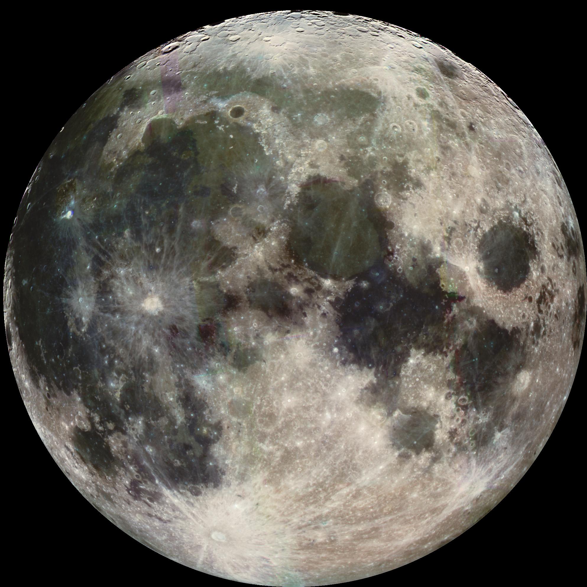
A photograph of the full moon, from photojournal.jpl.nasa.gov catalog, specifically jpeg; Original Caption Released with Image: During its flight, the Galileo spacecraft returned images of the Moon. The Galileo spacecraft took these images on December 7, 1992 on its way to explore the Jupiter system in 1995-97. The distinct bright ray crater at the bottom of the image is the Tycho impact basin. The dark areas are lava rock filled impact basins: Oceanus Procellarum (on the left), Mare Imbrium (center left), Mare Serenitatis and Mare Tranquillitatis (center), and Mare Crisium (near the right edge). This picture contains images through the Violet, 756 nm, 968 nm filters. The color is 'enhanced' in the sense that the CCD camera is sensitive to near infrared wavelengths of light beyond human vision. The Galileo project is managed for NASA's Office of Space Science by the Jet Propulsion Laboratory.
Venus in real colors, processed from clear and blue filtered Mariner 10 images.
Source images are in the public domain (NASA)
Images processed by Ricardo Nunes, downloaded from http://www.astrosurf.com/nunes/explor/explor_m10.htmOriginal Caption Released with Image: This Voyager 2 picture of Oberon is the best the spacecraft acquired of Uranus' outermost moon. The picture was taken shortly after 3:30 a.m. PST on Jan. 24, 1986, from a distance of 660,000 kilometers (410,000 miles). The color was reconstructed from images taken through the narrow-angle camera's violet, clear and green filters. The picture shows features as small as 12 km (7 mi) on the moon's surface. Clearly visible are several large impact craters in Oberon's icy surface surrounded by bright rays similar to those seen on Jupiter's moon Callisto. Quite prominent near the center of Oberon's disk is a large crater with a bright central peak and a floor partially covered with very dark material. This may be icy, carbon-rich material erupted onto the crater floor sometime after the crater formed. Another striking topographic feature is a large mountain, about 6 km (4 mi) high, peeking out on the lower left limb. The Voyager project is managed for NASA by the Jet Propulsion Laboratory.
(c) Brallan, CC-BY-SA-3.0
Graphical representation of two theories of the internal structure of Charon, Plutos moon
"The Blue Marble" is a famous photograph of the Earth taken on December 7, 1972, by the crew of the Apollo 17 spacecraft en route to the Moon at a distance of about 29,000 kilometres (18,000 mi). It shows Africa, Antarctica, and the Arabian Peninsula.
*Interior of Europa
- original description: Cutaway view of the possible internal structure of Europa The surface of the satellite is a mosaic of images obtained in 1979 by NASA's Voyager spacecraft. The interior characteristics are inferred from gravity field and magnetic field measurements by NASA's Galileo spacecraft. Europa's radius is 1565 km, not too much smaller than our Moon's radius. Europa has a metallic (iron, nickel) core (shown in gray) drawn to the correct relative size. The core is surrounded by a rock shell (shown in brown). The rock layer of Europa (drawn to correct relative scale) is in turn surrounded by a shell of water in ice or liquid form (shown in blue and white and drawn to the correct relative scale). The surface layer of Europa is shown as white to indicate that it may differ from the underlying layers. Galileo images of Europa suggest that a liquid water ocean might now underlie a surface ice layer several to ten kilometers thick. However, this evidence is also consistent with the existence of a liquid water ocean in the past. It is not certain if there is a liquid water ocean on Europa at present.
Original Caption Released with Image: The southern hemisphere of Umbriel displays heavy cratering in this Voyager 2 image, taken Jan. 24, 1986, from a distance of 557,000 kilometers (346,000 miles). This frame, taken through the clear-filter of Voyager's narrow-angle camera, is the most detailed image of Umbriel, with a resolution of about 10 km (6 mi). Umbriel is the darkest of Uranus' larger moons and the one that appears to have experienced the lowest level of geological activity. It has a diameter of about 1,200 km (750 mi) and reflects only 16 percent of the light striking its surface; in the latter respect, Umbriel is similar to lunar highland areas. Umbriel is heavily cratered but lacks the numerous bright ray craters seen on the other large Uranian satellites; this results in a relatively uniform surface albedo (reflectivity). The prominent crater on the terminator (upper right) is about 110 km (70 mi) across and has a bright central peak. The strangest feature in this image (at top) is a curious bright ring, the most reflective area seen on Umbriel. The ring is about 140 km (90 miles) in diameter and lies near the satellite's equator. The nature of the ring is not known, although it might be a frost deposit, perhaps associated with an impact crater. Spots against the black background are due to 'noise' in the data. The Voyager project is managed for NASA by the Jet Propulsion Laboratory.
Autor: Lennart Kudling, Licencja: CC BY 3.0
The inner structure of the Moon (from innermost): core (yellow, r=160km), primitive mantle (orange, r=1188km), depleted mantle (blue, r=1670km), crust (grey, r=1738km)
This is the highest-resolution picture of Titania returned by Voyager 2. The picture is a composite of two images taken Jan. 24, 1986, through the clear filter of Voyager's narrow-angle camera. At the time, the spacecraft was 369,000 kilometers (229,000 miles) from the Uranian moon; the resolution was 13 km (8 mi). Titania is the largest satellite of Uranus, with a diameter of a little more than 1,600 km (1,000 mi). Abundant impact craters of many sizes pockmark the ancient surface. The most prominent features are fault valleys that stretch across Titania. They are up to 1,500 km (nearly 1,000 mi) long and as much as 75 km (45 mi) wide. In valleys seen at right-center, the sunward-facing walls are very bright. While this is due partly to the lighting angle, the brightness also indicates the presence of a lighter material, possibly young frost deposits. An impact crater more than 200 km (125 mi) in diameter distinguishes the very bottom of the disk; the crater is cut by a younger fault valley more than 100 km (60 mi) wide. An even larger impact crater, perhaps 300 km (180 mi) across, is visible at top. The Voyager project is managed for NASA by the Jet Propulsion Laboratory.
The original NASA image has been altered by cropping, doubling the linear pixel density, sharpening and enhancing contrast.
Interior of Ganymede: Voyager images are used to create a global view of Ganymede. The cut-out reveals the interior structure of this icy moon. This structure consists of four layers based on measurements of Ganymede's gravity field and theoretical analyses using Ganymede's known mass, size and density. Ganymede's surface is rich in water ice and Voyager and Galileo images show features which are evidence of geological and tectonic disruption of the surface in the past. As with the Earth, these geological features reflect forces and processes deep within Ganymede's interior. Based on geochemical and geophysical models, scientists expected Ganymede's interior to either consist of: a) an undifferentiated mixture of rock and ice or b) a differentiated structure with a large lunar sized "core" of rock and possibly iron overlain by a deep layer of warm soft ice capped by a thin cold rigid ice crust. Galileo's measurement of Ganymede's gravity field during its first and second encounters with the huge moon have basically confirmed the differentiated model and allowed scientists to estimate the size of these layers more accurately. In addition the data strongly suggest that a dense metallic core exists at the center of the rock core. This metallic core suggests a greater degree of heating at sometime in Ganymede's past than had been proposed before and may be the source of Ganymede's magnetic field discovered by Galileo's space physics experiments.
Autor: Joel Holdsworth (Joelholdsworth), Licencja: CC-BY-SA-3.0
Diagram of the interior structure of the planet Mercury
- Crust - 100-200km thick
- Mantle - 600km thick
- Nucleus - 1,800km radius

Autor: SoylentGreen, Licencja: CC-BY-SA-3.0
A wood texture (Rings) allows for the 3-dimensional texturing of the earths core.
Ceres in true color taken by Dawn on May 4, 2015. Oxo Crater, Haulani Crater, and Ahuna Mons are visible.
Charon, taken by New Horizons late on 13 July 2015
_from_Voyager_1.jpg)
This image of Rhea was acquired by the Voyager 1 spacecraft on November 11, 1980.

Neptune
Original Caption Released with Image: During August 16 and 17, 1989, the Voyager 2 narrow-angle camera was used to photograph Neptune almost continuously, recording approximately two and one-half rotations of the planet. These images represent the most complete set of full disk Neptune images that the spacecraft will acquire. This picture from the sequence shows two of the four cloud features which have been tracked by the Voyager cameras during the past two months. The large dark oval near the western limb (the left edge) is at a latitude of 22 degrees south and circuits Neptune every 18.3 hours. The bright clouds immediately to the south and east of this oval are seen to substantially change their appearances in periods as short as four hours. The second dark spot, at 54 degrees south latitude near the terminator (lower right edge), circuits Neptune every 16.1 hours. This image has been processed to enhance the visibility of small features, at some sacrifice of color fidelity. The Voyager Mission is conducted by JPL for NASA's Office of Space Science and Applications.
This mosaic of the four highest-resolution images of Ariel represents the most detailed Voyager 2 picture of this satellite of Uranus. The images were taken through the clear filter of Voyager's narrow-angle camera on Jan. 24, 1986, at a distance of about 130,000 kilometers (80,000 miles). Ariel is about 1,200 km (750 mi) in diameter; the resolution here is 2.4 km (1.5 mi). Much of Ariel's surface is densely pitted with craters 5 to 10 km (3 to 6 mi) across. These craters are close to the threshold of detection in this picture. Numerous valleys and fault scarps crisscross the highly pitted terrain. Voyager scientists believe the valleys have formed over down-dropped fault blocks (graben); apparently, extensive faulting has occurred as a result of expansion and stretching of Ariel's crust. The largest fault valleys, near the terminator at right, as well as a smooth region near the center of this image, have been partly filled with deposits that are younger and less heavily cratered than the pitted terrain. Narrow, somewhat sinuous scarps and valleys have been formed, in turn, in these young deposits. It is not yet clear whether these sinuous features have been formed by faulting or by the flow of fluids.
(c) Christiaan z niderlandzkiej Wikipedii, CC-BY-SA-3.0
De binnenkant van Pluto met verklaring
Gemaakt door medewerker van Wikipedia (met het programma Blender)
This cut-away illustrates a model of Jupiter's interior. In the upper layers the atmosphere transitions to a liquid state above a thick layer of metallic hydrogen. In the center there may be a solid core of heavier elements.

PIA20013: Enceladus (Artist Concept) - Updated Image - Released 26 October 2015.
http://photojournal.jpl.nasa.gov/catalog/PIA20013
This artist's rendering showing a cutaway view into the interior of Saturn's moon Enceladus. NASA's Cassini spacecraft discovered the moon has a global ocean and likely hydrothermal activity. A plume of ice particles, water vapor and organic molecules sprays from fractures in the moon's south polar region.
This graphic is an update to a previously published version (see PIA19656) that did not show the ice and ocean layers to scale. The revised graphic more accurately represents scientists' current understanding of the thickness of the layers.
The Cassini mission is a cooperative project of NASA, ESA (the European Space Agency) and the Italian Space Agency. The Jet Propulsion Laboratory, a division of the California Institute of Technology in Pasadena, manages the mission for NASA's Science Mission Directorate, Washington. The Cassini orbiter and its two onboard cameras were designed, developed and assembled at JPL. The imaging operations center is based at the Space Science Institute in Boulder, Colorado.
For more information about the Cassini-Huygens mission visit http://saturn.jpl.nasa.gov and http://www.nasa.gov/cassini.
Cutaway view of asteroid 1 Ceres. Observations of 1 Ceres, the largest known asteroid, have revealed that the object may be a "mini planet," and may contain large amounts of pure water ice beneath its surface. The observations by NASA's Hubble Space Telescope also show that Ceres shares characteristics of the rocky, terrestrial planets like Earth. Ceres' shape is almost round like Earth's, suggesting that the asteroid may have a "differentiated interior," with a rocky inner core and a thin, dusty outer crust.
PLUTO - NEW HORIZONS - July 14, 2015
ORIGINAL IMAGE DESCRIPTION:
Four images from New Horizons’ Long Range Reconnaissance Imager (LORRI) were combined with color data from the Ralph instrument to create this global view of Pluto. (The lower right edge of Pluto in this view currently lacks high-resolution color coverage.) The images, taken when the spacecraft was 280,000 miles (450,000 kilometers) away, show features as small as 1.4 miles (2.2 kilometers), twice the resolution of the single-image view taken on July 13 [2015].
UPLOADER NOTES:
The north polar region is at top, with bright Tombaugh Regio to the lower right of center and part of the dark Cthulhu Regio at lower left. Part of the dark Krun Regio is also visible at extreme lower right.
The original NASA image has been modified by doubling the linear pixel density and cropping.

This artist's concept, a cutaway view of Jupiter's moon Callisto, is based on recent data from NASA's Galileo spacecraft which indicates a salty ocean may lie beneath Callisto's icy crust.
These findings come as a surprise, since scientists previously believed that Callisto was relatively inactive. If Callisto has an ocean, that would make it more like another Jovian moon, Europa, which has yielded numerous hints of a subsurface ocean. Despite the tantalizing suggestion that there is an ocean layer on Callisto, the possibility that there is life in the ocean remains remote.
Callisto's cratered surface lies at the top of an ice layer, (depicted here as a whitish band), which is estimated to be about 200 kilometers (124 miles) thick. Immediately beneath the ice, the thinner blue band represents the possible ocean, whose depth must exceed 10 kilometers (6 miles), according to scientists studying data from Galileo's magnetometer. The mottled interior is composed of rock and ice.
Galileo's magnetometer, which studies magnetic fields around Jupiter and its moons, revealed that Callisto's magnetic field is variable. This may be caused by varying electrical currents flowing near Callisto's surface, in response to changes in the background magnetic field as Jupiter rotates. By studying the data, scientists have determined that the most likely place for the currents to flow would be a layer of melted ice with a high salt content.
These findings were based on information gathered during Galileo's flybys of Callisto in November 1996, and June and September of 1997. JPL manages the Galileo mission for NASA's Office of Space Science, Washington, DC.Cutaway view of the possible internal structure of Io The surface of the satellite is a mosaic of images obtained in 1979 by NASA's Voyager spacecraft The interior characteristics are inferred from gravity field and magnetic field measurements by NASA's Galileo spacecraft. Io's radius is 1821 km, similar to the 1738 km radius of our Moon; Io has a metallic (iron, nickel) core (shown in gray) drawn to the correct relative size. The core is surrounded by a rock shell (shown in brown). Io's rock or silicate shell extends to the surface.
The inner structure of Venus – the crust (thin outer brown layer), the mantle (red middle layer) and the core (yellow inner layer)
This picture of Dione was take by Voyager 1 from a range of 162,000 kilometers on November 12, 1980. Many impact craters -- the record of the collision of cosmic debris -- are shown, the largest crater is less than 100 kilometers (62 miles) in diameter and shows a well-developed central peak. Bright rays represent material ejected from other impact craters. Sinuous valleys probably formed by faults break the moon's icy crust.