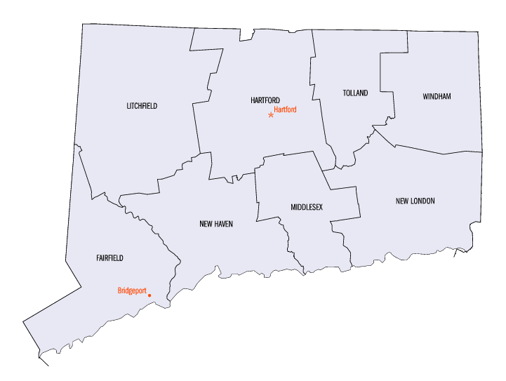
Lista hrabstw w stanie Connecticut
Poniżej przedstawiono listę hrabstw w stanie Connecticut. Stan Connecticut podzielony jest na 8 hrabstw. Hrabstwa w stanie Connecticut nie mają stolic, ponieważ są one jednostkami geograficznymi, a nie samorządowymi[1].
Lista alfabetyczna
| Nazwa | Kod FIPS | Powierzchnia całkowita (km²) | Powierzchnia lądowa (km²) | Powierzchnia wodna (km²) | Populacja (2000) | Gęstość zaludnienia (os/km²) (2000) | Położenie na mapie |
|---|---|---|---|---|---|---|---|
| Hrabstwo Fairfield | 09001 | 2167,72 | 1620,81 | 546,88 | 882567 | 544,5 |  |
| Hrabstwo Hartford | 09003 | 1943,97 | 1904,78 | 39,19 | 857183 | 450,0 |  |
| Hrabstwo Litchfield | 09005 | 2446,43 | 2382,58 | 63,84 | 182193 | 76,5 |  |
| Hrabstwo Middlesex | 09007 | 1137,19 | 956,38 | 180,81 | 155071 | 162,1 |  |
| Hrabstwo New Haven | 09009 | 2232,62 | 1568,60 | 664,02 | 824008 | 525,3 |  |
| Hrabstwo New London | 09011 | 1998,59 | 1724,70 | 273,89 | 259088 | 150,2 |  |
| Hrabstwo Tolland | 09013 | 1080,05 | 1062,08 | 17,97 | 136364 | 128,4 |  |
| Hrabstwo Windham | 09015 | 1350,60 | 1328,02 | 22,56 | 109091 | 82,2 |  |
Przypisy
- ↑ About Connecticut Government State of Connecticut (en)
Bibliografia
- Statystyki hrabstw w stanie Connecticut. factfinder.census.gov. [zarchiwizowane z tego adresu (2010-03-16)]. US Census Bureau (en)
Media użyte na tej stronie
This is a locator map showing Windham County in Connecticut. For more information, see Commons:United States county locator maps.
This is a locator map showing Tolland County in Connecticut. For more information, see Commons:United States county locator maps.
This is a locator map showing Fairfield County in Connecticut. For more information, see Commons:United States county locator maps.
This is a locator map showing New London County in Connecticut. For more information, see Commons:United States county locator maps.
The image was downloaded from en.wiki (en:Image:Connecticut-counties-map.gif) under the {{PD-USGov}} license tag. Wars 05:30, 12 September 2006 (UTC)
This is a locator map showing Litchfield County in Connecticut. For more information, see Commons:United States county locator maps.
This is a locator map showing Hartford County in Connecticut. For more information, see Commons:United States county locator maps.
This is a locator map showing Middlesex County in Connecticut. For more information, see Commons:United States county locator maps.
This is a locator map showing New Haven County in Connecticut. For more information, see Commons:United States county locator maps.


