Lista hrabstw w stanie Maine
Lista hrabstw w stanie Maine obejmuje 16 jednostek administracyjnych.
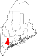
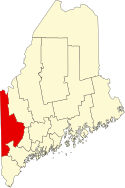
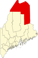
| Nazwa | kod FIPS[1] | Siedziba[2] | Powierzchnia całkowita (km²)[3] | Populacja (2009)[1] | Data powstania[2] | Położenie na mapie |
|---|---|---|---|---|---|---|
| Androscoggin | 23001 | Auburn | 1287,82 | 106 539 | 1854 |  |
| Aroostook | 23003 | Houlton | 17 686,48 | 71 488 | 1839 |  |
| Cumberland | 23005 | Portland | 3151,73 | 278 559 | 1760 |  |
| Franklin | 23007 | Farmington | 4517,74 | 29 735 | 1838 |  |
| Hancock | 23009 | Ellsworth | 6089,14 | 53 447 | 1789 |  |
| Kennebec | 23011 | Augusta | 2463,54 | 121 090 | 1799 |  |
| Knox | 23013 | Rockland | 2958,03 | 40 801 | 1860 |  |
| Lincoln | 23015 | Wiscasset | 1812,5 | 34 576 | 1760 |  |
| Oxford | 23017 | Paris | 5633,9 | 56 244 | 1805 |  |
| Penobscot | 23019 | Bangor | 9210,36 | 149 419 | 1816 |  |
| Piscataquis | 23021 | Dover-Foxcroft | 11 337,31 | 16 795 | 1838 |  |
| Sagadahoc | 23023 | Bath | 958,79 | 36 391 | 1854 |  |
| Somerset | 23025 | Skowhegan | 10 606,96 | 50 947 | 1809 |  |
| Waldo | 23027 | Belfast | 2208,59 | 38 287 | 1827 |  |
| Washington | 23029 | Machias | 8430,18 | 32 107 | 1789 |  |
| York | 23031 | Alfred | 3292,76 | 201 876 | 1636 |  |
Przypisy
- ↑ a b US Census Bureau: Maine Quickfacts (ang.). [dostęp 2010-10-18].
- ↑ a b Maine.gov: Local (ang.). [dostęp 2010-10-18].
- ↑ US Census Bureau: Maine County. Population, Housing Units, Area, and Density: 2000 (ang.). [dostęp 2010-10-18].
Media użyte na tej stronie
Map of Maine highlighting Androscoggin County.svg
This is a locator map showing Androscoggin County in Maine. For more information, see Commons:United States county locator maps.
This is a locator map showing Androscoggin County in Maine. For more information, see Commons:United States county locator maps.
Map of Maine highlighting Washington County.svg
This is a locator map showing Washington County in Maine. For more information, see Commons:United States county locator maps.
This is a locator map showing Washington County in Maine. For more information, see Commons:United States county locator maps.
Map of Maine highlighting Knox County.svg
This is a locator map showing Knox County in Maine. For more information, see Commons:United States county locator maps.
This is a locator map showing Knox County in Maine. For more information, see Commons:United States county locator maps.
Map of Maine highlighting Franklin County.svg
This is a locator map showing Franklin County in Maine. For more information, see Commons:United States county locator maps.
This is a locator map showing Franklin County in Maine. For more information, see Commons:United States county locator maps.
Map of Maine highlighting Kennebec County.svg
This is a locator map showing Kennebec County in Maine. For more information, see Commons:United States county locator maps.
This is a locator map showing Kennebec County in Maine. For more information, see Commons:United States county locator maps.
Map of Maine highlighting Waldo County.svg
This is a locator map showing Waldo County in Maine. For more information, see Commons:United States county locator maps.
This is a locator map showing Waldo County in Maine. For more information, see Commons:United States county locator maps.
Map of Maine highlighting Cumberland County.svg
This is a locator map showing Cumberland County in Maine. For more information, see Commons:United States county locator maps.
This is a locator map showing Cumberland County in Maine. For more information, see Commons:United States county locator maps.
Maine-counties-map.gif
Map delineating State of Maine (USA) Counties.
Map delineating State of Maine (USA) Counties.
Map of Maine highlighting Oxford County.svg
This is a locator map showing Oxford County in Maine. For more information, see Commons:United States county locator maps.
This is a locator map showing Oxford County in Maine. For more information, see Commons:United States county locator maps.
Map of Maine highlighting Lincoln County.svg
This is a locator map showing Lincoln County in Maine. For more information, see Commons:United States county locator maps.
This is a locator map showing Lincoln County in Maine. For more information, see Commons:United States county locator maps.
Map of Maine highlighting Somerset County.svg
This is a locator map showing Somerset County in Maine. For more information, see Commons:United States county locator maps.
This is a locator map showing Somerset County in Maine. For more information, see Commons:United States county locator maps.
Map of Maine highlighting Aroostook County.svg
This is a locator map showing Aroostook County in Maine. For more information, see Commons:United States county locator maps.
This is a locator map showing Aroostook County in Maine. For more information, see Commons:United States county locator maps.
Map of Maine highlighting York County.svg
This is a locator map showing York County in Maine. For more information, see Commons:United States county locator maps.
This is a locator map showing York County in Maine. For more information, see Commons:United States county locator maps.
Map of Maine highlighting Penobscot County.svg
Locator map showing Penobscot County — in Maine.
Locator map showing Penobscot County — in Maine.
- Credits
- For more information, see Commons:United States county locator maps.
Map of Maine highlighting Piscataquis County.svg
This is a locator map showing Piscataquis County in Maine. For more information, see Commons:United States county locator maps.
This is a locator map showing Piscataquis County in Maine. For more information, see Commons:United States county locator maps.
Map of Maine highlighting Hancock County.svg
This is a locator map showing Hancock County in Maine. For more information, see Commons:United States county locator maps.
This is a locator map showing Hancock County in Maine. For more information, see Commons:United States county locator maps.
Map of Maine highlighting Sagadahoc County.svg
This is a locator map showing Sagadahoc County in Maine. For more information, see Commons:United States county locator maps.
This is a locator map showing Sagadahoc County in Maine. For more information, see Commons:United States county locator maps.


