Little Mackinaw Bay
| Państwo | |
|---|---|
| Stan | |
| Lokalizacja | |
 mapa Teton Range ze Little Mackinaw Bay | |
Położenie na mapie Wyomingu  | |
Położenie na mapie Stanów Zjednoczonych  | |
Little Mackinaw Bay – zatoka jeziora Jackson Lake na terenie hrabstwa Teton w Wyoming[1][2][3].
Przypisy
- ↑ Recreation.gov, Recreation.gov [dostęp 2020-01-20] (ang.).
- ↑ Little Mackinaw Bay, Mapcarta [dostęp 2020-01-20] (ang.).
- ↑ Little Mackinaw Bay Topo Map, Teton County WY (Colter Bay Area), TopoZone [dostęp 2020-01-20] (ang.).
Media użyte na tej stronie
USA Wyoming relief location map.svg
Autor: ikonact, Licencja: CC BY-SA 4.0
Relief location map of Wyoming, USA
Autor: ikonact, Licencja: CC BY-SA 4.0
Relief location map of Wyoming, USA
Geographic limits of the map:
- N: 45.2° N
- S: 40.8° N
- W: 111.3° W
- E: 103.9° W
Usa edcp relief location map.png
Autor: Uwe Dedering, Licencja: CC BY-SA 3.0
Relief location map of the USA (without Hawaii and Alaska).
Autor: Uwe Dedering, Licencja: CC BY-SA 3.0
Relief location map of the USA (without Hawaii and Alaska).
EquiDistantConicProjection : Central parallel :
* N: 37.0° N
Central meridian :
* E: 96.0° W
Standard parallels:
* 1: 32.0° N
* 2: 42.0° N
Made with Natural Earth. Free vector and raster map data @ naturalearthdata.com.
Formulas for x and y:
x = 50.0 + 124.03149777329222 * ((1.9694462586094064-({{{2}}}* pi / 180))
      * sin(0.6010514667026994 * ({{{3}}} + 96) * pi / 180))
y = 50.0 + 1.6155950752393982 * 124.03149777329222 * 0.02613325650382181
      - 1.6155950752393982  * 124.03149777329222 *
     (1.3236744353715044  - (1.9694462586094064-({{{2}}}* pi / 180))
      * cos(0.6010514667026994 * ({{{3}}} + 96) * pi / 180))

Flag of the United States.svg
The flag of Navassa Island is simply the United States flag. It does not have a "local" flag or "unofficial" flag; it is an uninhabited island. The version with a profile view was based on Flags of the World and as a fictional design has no status warranting a place on any Wiki. It was made up by a random person with no connection to the island, it has never flown on the island, and it has never received any sort of recognition or validation by any authority. The person quoted on that page has no authority to bestow a flag, "unofficial" or otherwise, on the island.
The flag of Navassa Island is simply the United States flag. It does not have a "local" flag or "unofficial" flag; it is an uninhabited island. The version with a profile view was based on Flags of the World and as a fictional design has no status warranting a place on any Wiki. It was made up by a random person with no connection to the island, it has never flown on the island, and it has never received any sort of recognition or validation by any authority. The person quoted on that page has no authority to bestow a flag, "unofficial" or otherwise, on the island.

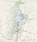
NPS grand-teton-map.pdf
Main Grand Teton map from the official brochure, showing the roads, trails, lakes, visitor centers, and points of interest.
Main Grand Teton map from the official brochure, showing the roads, trails, lakes, visitor centers, and points of interest.