Little Wigborough
(c) Robert Edwards, CC BY-SA 2.0 | |
| Państwo | |
|---|---|
| Kraj | |
| Hrabstwo | |
| Dystrykt | |
| Populacja (1951) • liczba ludności |
|
Położenie na mapie hrabstwa Essex Contains Ordnance Survey data © Crown copyright and database right, CC BY-SA 3.0 | |
Położenie na mapie Wielkiej Brytanii (c) Karte: NordNordWest, Lizenz: Creative Commons by-sa-3.0 de | |
| Portal | |
Little Wigborough – wieś w Anglii, w Esseksie, w dystrykcie Colchester, w civil parish Great and Little Wigborough.[1] W 1951 wieś liczyła 45 mieszkańców.[2]
I wojna światowa
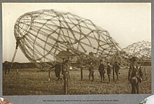
24 września 1916 we wsi wylądował powracający z ataku na Londyn, uszkodzony niemiecki sterowiec L 33 (na którym służył późniejszy admirał Ernst Schirlitz). Załoga następnie próbowała spalić sterowiec, zanim została powstrzymana przez lokalnego konstabla[3].
Przypisy
- ↑ Little Wigborough AP/CP through time | Census tables with data for the Parish-level Unit, www.visionofbritain.org.uk [dostęp 2017-11-18].
- ↑ Little Wigborough AP/CP through time | Population Statistics | Total Population, www.visionofbritain.org.uk [dostęp 2017-11-18].
- ↑ Member's Articles - Colchester Metal Detecting Club, web.archive.org, 29 czerwca 2011 [dostęp 2020-06-16] [zarchiwizowane z adresu 2011-06-29].
Linki zewnętrzne
Media użyte na tej stronie
Contains Ordnance Survey data © Crown copyright and database right, CC BY-SA 3.0
Map of Essex, UK with the following information shown:
- Administrative borders
- Coastline, lakes and rivers
- Roads and railways
- Urban areas
Equirectangular map projection on WGS 84 datum, with N/S stretched 160%
Geographic limits:
- West: 0.06W
- East: 1.32E
- North: 52.11N
- South: 51.42N
(c) Karte: NordNordWest, Lizenz: Creative Commons by-sa-3.0 de
Location map of the United Kingdom
Flag of England. Saint George's cross (a red cross on a white background), used as the Flag of England, the Italian city of Genoa and various other places.
Autor: H. D. Girdwood , Licencja: CC0
The skeleton of an airship which crashed in a field. 1915.
Collection note: "The photographs appear in a variety of sizes, shapes and colours including shades of blue, green and brown. They record scenes of military life as experienced by the Indian and British armies in France during the First World War."
Added: This is the wreck of Zeppelin LZ 76 (also designated L 33), which was torched by its crew after making a forced landing at Little Wigborough, near Colchester in Essex, after sustaining serious damage from an anti-aircraft shell and British fighter aircraft, returning from a bombing raid over London on 23 September 1916,.(c) Robert Edwards, CC BY-SA 2.0
St. Nicholas church, Little Wigborough, Essex. This small late 15th-century church stands by Copt Hall.


