Litzendorf
| gmina | |||
| |||
| Państwo | |||
|---|---|---|---|
| Kraj związkowy | |||
| Rejencja | Górna Frankonia | ||
| Powiat | Bamberg | ||
| Kod statystyczny | 09 4 71 155 | ||
| Powierzchnia | 25,85 km² | ||
| Wysokość | 311 m n.p.m. | ||
| Populacja (31 grudnia 2011) • liczba ludności | 6 011 | ||
| • gęstość | 233 os./km² | ||
| Numer kierunkowy | 09505 | ||
| Kod pocztowy | 96123 | ||
| Tablice rejestracyjne | BA | ||
Adres urzędu: Am Knock 696123 Litzendorf | |||
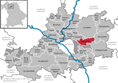
Położenie na mapie powiatu | |||
| 49°54′N 11°00′E/49,900000 11,000000 | |||
| Strona internetowa | |||
| Portal | |||
Litzendorf – miejscowość i gmina w Niemczech, w kraju związkowym Bawaria, w rejencji Górna Frankonia, w regionie Oberfranken-West, w powiecie Bamberg. Leży w Szwajcarii Frankońskiej, około 8 km na wschód od Bamberga.
Dzielnice
W skład gminy wchodzą następujące dzielnice:
 | Kunigundenruh | 2 | |
 |  | Litzendorf | 1 492 |
 |  | Lohndorf | 385 |
 | Melkendorf | 757 | |
 | Naisa | 747 | |
 | Pödeldorf | 1 753 | |
 | Schammelsdorf | 784 | |
 | Tiefenellern | 210 |
Demografia
| Rok | Liczba mieszk. |
| 1970 | 3507 |
| 1987 | 4825 |
| 2000 | 5907 |
| 2005 | 6179 |
| 2006 | 6129 |
Położenie
Litzendorf sąsiaduje z następującymi gminami:
 |  |  |  |  |  |
| Memmelsdorf | Scheßlitz | Königsfeld | Heiligenstadt in Oberfranken | Strullendorf | Hauptsmoorwald |
Polityka
Wójtem jest Wolfgang Möhrlein. Rada gminy składa się z 20 członków:
| CSU | SPD | Zieloni | Chrześcijańskie Stowarzyszenie Wyborców | Razem | |
| 2002 | 9 | 5 | 3 | 3 | 20 miejsc |
Media użyte na tej stronie
locator map of communities in the district (Landkreis) of Bamberg in Bavaria, Germany
locator map of communities in the district (Landkreis) of Bamberg in Bavaria, Germany
Tiefenellern in Germany
village in Germany
locator map of communities in the district (Landkreis) of Bamberg in Bavaria, Germany
locator map of communities in the district (Landkreis) of Bamberg in Bavaria, Germany
locator map of communities in the district (Landkreis) of Bamberg in Bavaria, Germany
|
|
|
|
|
|
|
|
Melkendorf, Germany
Autor: Immanuel Giel, Licencja: CC-BY-SA-3.0
Litzendorf, view of St Wenceslaus' Parish and rectory (from l. to r.) facing east.


