Llandovery
| ||
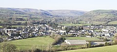
 Widok na Llandovery | ||
| Państwo | ||
| Księstwo | ||
| Hrabstwo | Carmarthenshire | |
| Populacja (2011) • liczba ludności | 2065[1] | |
| Kod pocztowy | SA20 | |
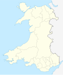
Położenie na mapie Carmarthenshire Contains Ordnance Survey data © Crown copyright and database right, CC BY-SA 3.0 | ||
Położenie na mapie Wielkiej Brytanii (c) Karte: NordNordWest, Lizenz: Creative Commons by-sa-3.0 de | ||
| Portal | ||
Llandovery (wal. Llanymddyfri) – miasto w południowej Walii, w hrabstwie Carmarthenshire, położone u zbiegu rzek Tywi (Towy), Brân i Gwydderig, na skraju parku narodowego Brecon Beacons[2]. W 2011 roku liczyło 2065 mieszkańców[1].
Miejscowość otrzymała prawa miejskie w 1484 roku. Jej nazwa oznacza w języku walijskim „kościół pośród wód”[3]. Znajdują się tu ruiny zamku z XII wieku[4].
Mieści się tu stacja kolejowa, na linii Heart of Wales[5].
Przypisy
- ↑ a b Llandovery Built-up area Local Area Report (ang.). Nomis. [dostęp 2018-11-28].
- ↑ Mapa OS Explorer 187, Ordnance Survey (ang.).
- ↑ Llanymddyfri, Carmarthenshire (ang.). A vision of Britain through time. [dostęp 2018-11-28].
- ↑ Plantagenet Somerset Fry: Castles: England, Scotland, Wales, Ireland: the definitive guide to the most impressive buildings and intriguing sites. David & Charles, 2005, s. 194. ISBN 0-7153-2212-5. (ang.)
- ↑ Discover (ang.). The Heart of Wales Line. [dostęp 2018-11-28].
Media użyte na tej stronie
(c) Karte: NordNordWest, Lizenz: Creative Commons by-sa-3.0 de
Location map of the United Kingdom
Autor: NordNordWest, Licencja: CC BY-SA 3.0
Location map of Wales, United Kingdom
Contains Ordnance Survey data © Crown copyright and database right, CC BY-SA 3.0
Blank map of Carmarthenshire, UK with the following information shown:
- Administrative borders
- Coastline, lakes and rivers
- Roads and railways
- Urban areas
Equirectangular map projection on WGS 84 datum, with N/S stretched 160%
Geographic limits:
- West: 4.75W
- East: 3.58W
- North: 52.15N
- South: 51.58N
Панорамен изглед от Ландъври


