Lodowiec Szelfowy Larsena
 Półwysep Antarktyczny z Lodowcem Szelfowym Larsena w październiku 2011 roku | |
| Terytorium | |
|---|---|
| Rodzaj | |
| Klasa lodowca | |
| Forma lodowca | grupowa |
| Typ czoła | regularne |
| Trend fluktuacji | dezintegracja |
Położenie na mapie Półwyspu Antarktycznego  | |
Położenie na mapie Antarktyki  | |

Lodowiec Szelfowy Ronne i Lodowiec Szelfowy Filchnera
Larsen C

Lodowiec Szelfowy Larsena[1] (ang. Larsen Ice Shelf, hiszp.Barrera de Hielos Larsen) – lodowiec szelfowy w północno-zachodniej części Morza Weddella, przylegający do Półwyspu Antarktycznego, od lat 90. XX w. ulegający stopniowemu rozpadowi pod wpływem zmian klimatycznych.
Nazwany na cześć norweskiego kapitana Carla Antona Larsena (1860–1924), który w grudniu 1893 roku popłynął wzdłuż lodowca aż do szerokości 68°10'S.
Geografia
Lodowiec Szelfowy Larsena przylega do wschodniego wybrzeża Półwyspu Antarktycznego[2]. Na przestrzeni ostatnich 30 lat zaczął ulegać dezintegracji pod wpływem zmian klimatycznych[3].
Pod koniec lat 80. XX w. Lodowiec Szelfowy Larsena rozciągał się od Prince Gustav Channel na północy po Cape Fiske na półwyspie Smith Peninsula na południu[2]. Jego powierzchnia wynosiła wówczas 103 400 km²[2][a]. Na lodowcu można było wyróżnić pięć głównych części: obszar w Prince Gustav Channel, obszar między Sobral Peninsula a Wyspą Robertsona – tzw. Larsen A, obszar między Wyspą Robertsona a Jason Peninsula – tzw. Larsen B, obszar między Jason Peninsula a Gibbs Ice Rise – tzw. Larsen C, obszar między Gibbs Ice Rise i Cape Fiske – tzw. Larsen D[2]. Dodatkowo wyróżniano regiony Larsen Inlet i Seal Nunataks[2].
Od połowy lat 40. XX w., kiedy zaczęto dokumentować zmiany, regresji uległ obszar w Prince Gustav Channel, podczas gdy Larsen A powiększał się do 1975 roku a Larsen B do 1995 roku[2]. Wraz ze wzrostem temperatury pod koniec XX w., Lodowiec Szelfowy Larsena zaczął się kurczyć[4]. Temperatura powietrza w regionie wzrosła od lat 40. XX w. o 2,5 °C, a temperatura wody Morza Weddella podniosła się o 0,32 °C od lat 70[5].
Lodowiec przy Larsen Inlet uległ rozpadowi w okresie 1989–1992, a Larsen A i obszar w Prince Gustav Channel uległy dezintegracji na przestrzeni kilku tygodni w styczniu-lutym 1995 roku[2]. W lutym-marcu 2002 roku od Larsena B oderwała się część na północ od Cape Disappoinment[2], o powierzchni 3250 km²[6]. W styczniu 2005 roku powierzchnia Lodowca Szelfowego Larsena zmalała o ok. 24% do ok. 78 515 km²[2][b]
Larsen C zaczął pękać w pierwszych latach XXI wieku – pojawiła się szczelina, która najpierw rosła stopniowo, a potem bardzo szybko powiększyła się w ciągu jednego roku[4]. W latach 2012–2017 rozwój szczeliny obserwowany był przy pomocy satelitów NASA i ESA[4]. W lipcu 2017 roku satelita Sentinel-1 zaobserwował, że pęknięcie dotarło do krawędzi lodowca, oddzielając od niego wyspę lodową o powierzchni ok. 6000 km²[7] (co stanowiło 12% powierzchni Larsena C)[4]. US National Ice Center nazwało oderwany fragment A-68[8], który wkrótce pod wpływem prądów, fal i wiatrów rozpadł się na dwie części – A-68A i A-68B[9]. Encyklopedia Britannica podaje, że w 2017 roku powierzchnia Lodowca Szelfowego Larsena wynosiła 68 000 km²[4].
Latem 2019/2020 sezonowe topnienie lodowca Larsen C trwało dłużej i było bardziej intensywne niż w jakimkolwiek sezonie letnim na przestrzeni ostatnich 40 lat[10]. Ten rekordowy sezon przerwał trwający prawie dwie dekady trend zmniejszającego się topnienia i prawdopodobnie zapoczątkował proces „chudnięcia” lodowca wskutek utraty powietrza z firnu[10].
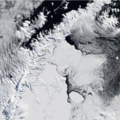
Lodowiec Szelfowy Larsena i wybrzeże kontynentu, 2004 rok
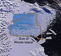
Rozpad lodowca Larsen B – oderwany fragment o powierzchni ok. 3250 km²; dla porównania kontur stanu Rhode Island (pow. ok. 3150 km²), zob. Wellner et al. 2019 ↓
Fragmenty lodowca Larsen B utrzymywały się w zatoce do 2005 roku

Rosnąca szczelina w lodowcu Larsen C

Oderwanie się góry lodowej A-68 od lodowca Larsen C w lipcu 2017 roku

Larsen C i zachodni brzeg A-68 (w prawym górnym rogu)

Historia
Lodowiec został odkryty w grudniu 1893 roku przez norweskiego wielorybnika Carla Antona Larsena (1860–1924) podczas jego drugiej wyprawy na statku „Jason” w poszukiwaniu wielorybów na wodach Oceanu Południowego[11]. „Jason” badał obszar na wschód od Półwyspu Antarktycznego, i dotarł na szerokość 68°10'S – najdalej na południe wzdłuż wschodniego wybrzeża Półwyspu Antarktycznego niż wówczas jakikolwiek inny statek[12][13]. Lodowiec został nazwany później na cześć odkrywcy[14].
Uwagi
- ↑ Encyklopedia Britannica podaje, że początkowa powierzchnia lodowca wynosiła 86000 km², zob. Encyclopædia Britannica 2019 ↓.
- ↑ Encyklopedia Britannica podaje, że powierzchnia lodowca zmalała o ok. 40%, zob.Encyclopædia Britannica 2019 ↓.
Przypisy
- ↑ Polska nazwa według Komisja Standaryzacji Nazw Geograficznych poza Granicami Rzeczypospolitej Polskiej: wykaz polskich nazw Antarktyki
- ↑ a b c d e f g h i de Angelis 2007 ↓, s. 585.
- ↑ Etourneau et al. 2019 ↓.
- ↑ a b c d e Encyclopædia Britannica 2019 ↓.
- ↑ de Angelis 2007 ↓, s. 586.
- ↑ Wellner et al. 2019 ↓.
- ↑ Sentinel satellite captures birth of behemoth iceberg. Europejska Agencja Kosmiczna, 2017-07-12. [dostęp 2020-08-25].
- ↑ Kathryn Hansen: A-68 Adrift. [w:] earthobservatory.nasa.gov [on-line]. [dostęp 2020-08-25]. (ang.).
- ↑ Kathryn Hansen: A Fracturing Berg in the Polar Night. [w:] earthobservatory.nasa.gov [on-line]. [dostęp 2020-08-25]. (ang.).
- ↑ a b Bevan et al. 2020 ↓, s. 6.
- ↑ Mills 2003 ↓, s. 373.
- ↑ Basberg 2007 ↓, s. 584.
- ↑ Jonsgård i Tjernshaugen 2020 ↓.
- ↑ SCAR Composite Gazetteer of Antarctica: Larsen Ice Shelf. [dostęp 2020-08-25]. (ang.).
Bibliografia
- Bjørn Lorens Basberg: Larsen, Carl Anton. W: Beau Riffenburgh: Encyclopedia of the Antarctic,. Taylor & Francis, 2007, s. 583–585. ISBN 978-0-415-97024-2. [dostęp 2020-08-25]. (ang.).
- Suzanne Bevan, Adrian Luckman, Harry Hendon, Guomin Wang. 2020 Larsen C Ice Shelf surface melt is a 40-year record high. „The Cryosphere Discussions”, in review, 2020. DOI: 10.5194/tc-2020-130. (ang.).
- Hernan de Angelis: Larsen Ice Shelf. W: Beau Riffenburgh: Encyclopedia of the Antarctic,. Taylor & Francis, 2007, s. 585–586. ISBN 978-0-415-97024-2. [dostęp 2020-08-25]. (ang.).
- Larsen Ice Shelf, [w:] Encyclopædia Britannica [online] [dostęp 2020-08-24] (ang.).
- Johan Etourneau, Giovanni Sgubin, Xavier Crosta, Didier Swingedouw, Verónica Willmott, Loïc Barbara, Marie-Noëlle Houssais, Stefan Schouten, Jaap S. Sinninghe Damsté, Hugues Goosse, Carlota Escutia, Julien Crespin, Guillaume Massé, Jung-Hyun Kim. Ocean temperature impact on ice shelf extent in the eastern Antarctic Peninsula. „Nature Communications”. 10 (1), 2019. DOI: 10.1038/s41467-018-08195-6. (ang.).
- Åge Jonsgård, Andreas Tjernshaugen: Carl Anton Larsen. W: Store norske leksikon. (norw. bokmål).
- Larsen, Carl Anton. W: William James Mills: Exploring Polar Frontiers. ABC-CLIO, 2003, s. 373–375. ISBN 978-1-57607-422-0. [dostęp 2020-08-25]. (ang.).
- Julia S. Wellner, Ted Scambos, Eugene W. Domack, Maria Vernet, Amy Leventer, Greg Balco, Stefanie Brachfeld, Mattias R. Cape, Bruce Huber,Scott Ishman, Michael L. McCormick, Ellen Mosley-Thompson, Erin C. Pettit, Craig R. Smith, Martin Truffer, Cindy Van Dover, Kyu-Cheul Yoo. The Larsen Ice Shelf System, Antarctica (LARISSA): Polar Systems Bound Together, Changing Fast. „GSA Today”. 29 (8), August 2019. The Geological Society of America. DOI: 10.1130/GSATG382A.1. (ang.).
Linki zewnętrzne
- Jakub Małecki: Rozpad lodowców szelfowych Półwyspu Antarktycznego. [w:] glacjoblogia.wordpress.com [on-line]. 2015-05-20. [dostęp 2020-08-25]. (pol.).
- National Snow and Ice Data Center (NSIDC): What happened to the Larsen Ice Shelf?. [w:] nsidc.org [on-line]. [dostęp 2021-12-30]. (ang.).
- Andrzej Hołdys: Rekordowe temperatury na Antarktydzie. Biały Ląd się budzi?. [w:] www.polityka.pl [on-line]. 2020-02-20. [dostęp 2020-08-25]. (pol.).
Media użyte na tej stronie
.jpg)
Autor: NASA Goddard Space Flight Center from Greenbelt, MD, USA, Licencja: CC BY 2.0
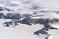
This is an photograph from the Oct. 31, 2017 Operation IceBridge flight over the Larsen C.
For the last nine years, NASA’s Operation IceBridge has been flying over Antarctica to measure changes in land and sea ice at the bottom of the world. Soon after beginning this year’s campaign, the mission flew over one of the most obvious signs of change in 2017: a giant iceberg the size of Delaware that recently calved off of the Larsen C ice shelf. This iceberg is more than 600 feet thick and has a total volume twice the size of Lake Erie. Even so, it won’t contribute any more to sea level rise, as it’s been floating as part of an ice shelf for a long time. Scientists are still researching whether the removal off all that ice will have any effect on the flow rates of glaciers upstream from the Larsen C.
Caption: The edge of Larsen C Ice Shelf with the western edge of iceberg A68 in the distance. NASA/Nathan Kurtz
Autor:
- Antarctic_Treaty_flag.svg: Alakasam.
- derivative work: B1mbo (talk)
Flag of the Antarctic Treaty
Autor: NordNordWest, Licencja: CC BY 3.0
Ta mapa została stworzona lub ulepszona w niemieckiej Kartenwerkstatt (Pracowni Kartograficznej). I Ty możesz zaproponować inne mapy do ulepszenia.
Autor: Alexrk2, Licencja: CC BY-SA 3.0
Location map Antarctica, Azimuthal equidistant projection

The fractured berg and shelf are visible in these images, acquired on July 21, 2017, by the Thermal Infrared Sensor (TIRS) on the Landsat 8 satellite. The false-color view shows the relative warmth or coolness across the region. White indicates where the ice or water surface is warmest, most notably in the widening strip of mélange between the main iceberg and the remaining ice shelf. Dark grays and blacks are the coldest areas of ice.

Autor: Robert A. Rohde, Licencja: CC-BY-SA-3.0
Photo glacier Larsen B et comparaison avec Rhode Island, USA

The first image was taken one year after the disintegration. Although not frozen solid, the bay is filled with mélange and icebergs, some of them tens of kilometres long. A thin corridor of open ocean, however, lines much of the remaining ice shelf. In the second image, ice continues to fill the bay, and even more ice appears in this image than is visible in the previous shot. Lingering mélange (small chunks of glacier ice and snow, sometimes mixed with sea ice) and icebergs have likely been supplemented by snow and sea ice. The difference between the last image and earlier shots is dramatic. Most of the ice that had lingered in the bay after the Larsen B’s collapse has drifted out to sea, and open ocean predominates. Isolated chunks of ice float on the sea surface far from the remaining edge of the shelf.

These photograph shows the wide view of the rift in Larsen C from the vantage point of NASA’s DC-8 research aircraft. NASA scientist John Sonntag snapped the photos on November 10, 2016, during an Operation IceBridge flight. The mission, which makes airborne surveys of changes in polar ice, completed its eighth consecutive Antarctic deployment later that month. The rift in Larsen C measures about 100 meters (300 feet) wide and cuts about half a kilometer (one-third of a mile) deep—completely through to the bottom of the ice shelf. While the rift is long and growing longer, it does not yet reach across the entire shelf.
(c) A. J. Cook and D. G. Vaughan, CC BY 3.0
The ice shelves of the Antarctic peninsula.
Clear view of the Antarctic Peninsula, the Larsen Ice Shelf, and the sea ice covered waters around the region. The Peninsula stands out as the raised terrain amidst the ice from the lower left to upper middle of the image.