London Borough of Bexley
| London Borough of | |||
 Hall Place | |||
| |||
| Państwo | |||
|---|---|---|---|
| Kraj | |||
| Region | |||
| Kod ISO 3166-2 | GB-BEX | ||
| Burmistrz | Peter Reader | ||
| Powierzchnia | 60,56 km² | ||
| Populacja (2016) • liczba ludności |
| ||
| • gęstość | 4042 os./km² | ||
| Kod pocztowy | SE2, SE9, SE28, DA1, DA5, DA6, DA7, DA8, DA14, DA15, DA16, DA17, DA18 | ||
| Położenie na mapie Wielkiego Londynu | |||
| Strona internetowa | |||
| Portal | |||
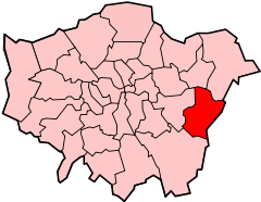
London Borough of Bexley – jedna z 32 gmin Wielkiego Londynu położona w jego wschodniej części. Wraz z 19 innymi gminami wchodzi w skład tzw. Londynu Zewnętrznego. Władzę stanowi Rada Gminy Bexley (ang. Bexley Council).
Historia
Gminę utworzono w 1965 roku na podstawie ustawy London Government Act 1963[2] z obszarów Bexley (ang. Municipal Borough of Bexley)[3] utworzonego w 1894 roku, Erith (ang. Municipal Borough of Erith)[4] utworzonego w 1938 roku, Crayford (ang. Crayford Urban District)[5] utworzonego w 1920 roku oraz z obszaru Chislehurst and Sidcup (ang. Chislehurst and Sidcup Urban District) utworzonego w 1934 roku - oprócz Chislehurst które zostało dołączone do Bromley[6]. Na terenie gminy w Crayford znajdowała się wybudowana w XIX wieku przez Hirama Maxima fabryka broni w której produkowano karabin maszynowy Maxim[7]. Fabryka pod koniec XIX wieku została przejęta przez firmę Vickers i działała aż do 1985 roku kiedy to została zamknięta, zaś pozostałe po fabryce budynki zostały ostatecznie zburzone w 1998 roku[8].
Geografia
Gmina Bexley ma powierzchnię 60,56 km2, od północy graniczy przez Tamizę z Barking and Dagenham i Havering oraz od północnego wschodu także przez Tamizę z dystryktem Thurrock w hrabstwie Essex, od zachodu z Greenwich, od południa z Bromley, zaś od wschodu z dystryktami Sevenoaks oraz Dartford w hrabstwie Kent.
W skład gminy Bexley wchodzą następujące obszary:
|
Gmina dzieli się na 21 okręgów wyborczych[9] które nie pokrywają się dokładnie z podziałem na obszary, zaś mieszczą się w trzech rejonach tzw. borough constituencies - Bexleyheath and Crayford, Erith and Thamesmead i Old Bexley and Sidcup[10].
|
|
Demografia
W 2011 roku gmina Bexley miała 231 997 mieszkańców[11].
Podział mieszkańców według grup etnicznych na podstawie spisu powszechnego z 2011 roku[12]:
|
|
Podział mieszkańców według wyznania na podstawie spisu powszechnego z 2011 roku[13]:
- Chrześcijaństwo - 62,1%
- Islam – 2,4%
- Hinduizm – 1,5%
- Judaizm – 0,1%
- Buddyzm – 0,6%
- Sikhizm – 1,8%
- Pozostałe religie – 0,3%
- Bez religii – 24,1%
- Nie podana religia – 7,0%
Podział mieszkańców według miejsca urodzenia na podstawie spisu powszechnego z 2011 roku[14]:
|
|
Transport
Bexley jest jedną z sześciu londyńskich gmin przez którą nie przebiega ani jedna linia metra.
Pasażerskie połączenia kolejowe na terenie Bexley obsługuje przewoźnik Southeastern.
Stacje kolejowe:
- Abbey Wood (na granicy z London Borough of Greenwich)
- Albany Park
- Barnehurst
- Belvedere
- Bexley
- Bexleyheath
- Crayford
- Erith
- Falconwood (na granicy z London Borough of Greenwich)
- Sidcup
- Slade Green
- Welling
Miejsca i muzea
- Crossness Pumping Station[15]
- Hall Place[16]
- Danson House[17]
- Red House [18]
- Sidcup Place[19]
- Geoffrey Whitworth Theatre[20]
- Erith Playhouse[21]
- Edward Alderton Theatre[22]
- Crayford Manor House Astronomical Society[23]
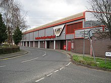
- Crayford Greyhound Track[24] (tory wyścigowe na których rozgrywane są wyścigi chartów)
- Sidcup Golf Club[25]
- Bexleyheath Golf Club[26]
- Barnehurst Golf Course[27]
- Thamesview Golf Centre[28]
Edukacja
- Bird College[29]
- Rose Bruford College[30]
- Adult Education College Bexley[31]
- Bexley College[32]
- Beths Grammar School[33]
- Bexley Grammar School[34]
- Bexleyheath Academy[35]
- Blackfen School for Girls[36]
- Business Academy Bexley[37]
- Chislehurst and Sidcup Grammar School[38]
- Cleeve Park School[39]
- Erith School[40]
- Haberdashers Aske’s Crayford Academy[41]
- Harris Academy Falconwood[42]
- Hurstmere School[43]
- St Catherine's Catholic School for Girls[44]
- St Columba's Catholic Boys' School[45]
- Townley Grammar School for Girls[46]
- Trinity School, Belvedere[47]
- Welling School[48]
- Christ the King: St Mary's Sixth Form College[49]
Znane osoby
W Bexley urodzili się m.in.
- John Paul Jones - producent, aranżer i multiinstrumentalista
- Steve Backley - lekkoatleta
- Kate Bush - piosenkarka
- Boy George – piosenkarz
- Wayne Routledge – piłkarz
- Mike Rann - polityk
- Liam Ridgewell – piłkarz
- Naomi Cavaday - tenisistka
Przypisy
- ↑ Population Estimates for UK, England and Wales, Scotland and Northern Ireland - Office for National Statistics, www.ons.gov.uk [dostęp 2017-10-16] (ang.).
- ↑ „ Legislation.gov.uk- London Government Act 1963”
- ↑ „visionofbritain.org.uk - unit history of Bexley”. [dostęp 2012-09-18]. [zarchiwizowane z tego adresu (2012-09-18)].
- ↑ „visionofbritain.org.uk - unit history of Erith”. [dostęp 2012-09-18]. [zarchiwizowane z tego adresu (2012-09-18)].
- ↑ „visionofbritain.org.uk - unit history of Crayford”. [dostęp 2012-12-24]. [zarchiwizowane z tego adresu (2012-12-24)].
- ↑ „visionofbritain.org.uk - unit history of Chislehurst and Sidcup”. [dostęp 2012-09-19]. [zarchiwizowane z tego adresu (2012-09-19)].
- ↑ „gunstribune.com - Hiram Maxim”
- ↑ „crayfordhistory.co.uk - Vickers Ltd of Crayford 1888-1985”
- ↑ „bexley.gov.uk – Election boundaries”. [dostęp 2012-01-22]. [zarchiwizowane z tego adresu (2012-04-24)].
- ↑ „ukpollingreport.co.uk-london”
- ↑ „ons.gov.uk – 2011 Census: KS102EW Age structure, local authorities in England and Wales”
- ↑ „ons.gov.uk – 2011 Census: KS201EW Ethnic group, local authorities in England and Wales”
- ↑ „ons.gov.uk – 2011 Census: KS209EW Religion, local authorities in England and Wales”
- ↑ „ons.gov.uk – 2011 Census: KS204EW Country of birth, local authorities in England and Wales”
- ↑ „crossness.org.uk - Crossness Pumping Station”
- ↑ „hallplace.org.uk - Hall Place”
- ↑ „dansonhouse.org.uk - Danson House”. [dostęp 2012-01-22]. [zarchiwizowane z tego adresu (2012-01-04)].
- ↑ „nationaltrust.org.uk - Red House ”
- ↑ „bexley.gov.uk - Sidcup Place”. [dostęp 2012-01-22]. [zarchiwizowane z tego adresu (2012-04-25)].
- ↑ „thegwt.org.uk - Geoffrey Whitworth Theatre”
- ↑ „playhouse.org.uk - Erith Playhouse”
- ↑ „edwardalderton.org - Edward Alderton Theatre”
- ↑ „cmhas.wikispaces.com - Crayford Manor House Astronomical Society”. [dostęp 2012-01-22]. [zarchiwizowane z tego adresu (2009-07-08)].
- ↑ „crayford.com - Crayford Greyhound Track”
- ↑ „sidcupgolfclub.co.uk - Sidcup Golf Club”
- ↑ „bexleyheath-golf.com - Bexleyheath Golf Club”
- ↑ „mytimeactive.co.uk - Barnehurst Golf Course”. [dostęp 2012-01-22]. [zarchiwizowane z tego adresu (2012-01-13)].
- ↑ „tvgc.co.uk - Thamesview Golf Centre”
- ↑ „birdcollege.co.uk - Bird College”
- ↑ „bruford.ac.uk - Rose Bruford College”
- ↑ „adultedbexley.co.uk - Adult Education College Bexley”. [dostęp 2012-01-22]. [zarchiwizowane z tego adresu (2012-01-06)].
- ↑ „bexley.ac.uk - Bexley College”. [dostęp 2012-01-22]. [zarchiwizowane z tego adresu (2012-02-09)].
- ↑ „beths.bexley.sch.uk - Beths Grammar School”. [dostęp 2012-01-22]. [zarchiwizowane z tego adresu (2012-01-27)].
- ↑ „bexleygs.co.uk - Bexley Grammar School”
- ↑ „bexleyheathacademy.org - Bexleyheath Academy”
- ↑ „blackfenschoolforgirls.co.uk - Blackfen School for Girls”
- ↑ „thebusinessacademy.org - Business Academy Bexley”
- ↑ „csgrammar.com - Chislehurst and Sidcup Grammar School”
- ↑ „cleevepark.org - Cleeve Park School”. [dostęp 2012-01-22]. [zarchiwizowane z tego adresu (2012-09-09)].
- ↑ „erith.kent.sch.uk - Erith School”. [dostęp 2012-01-22]. [zarchiwizowane z tego adresu (2012-01-09)].
- ↑ „haaf.org.uk - Haberdashers Aske’s Crayford Academy”. [dostęp 2012-09-09]. [zarchiwizowane z tego adresu (2012-09-09)].
- ↑ „harrisfalconwood.org.uk - Harris Academy Falconwood”
- ↑ „hurstmere.org.uk - Hurstmere School”
- ↑ „stccg.co.uk - St Catherine's Catholic School for Girls”
- ↑ „st-columbas.bexley.sch.uk - St Columba's Catholic Boys' School”
- ↑ „townleygrammar.org.uk - Townley Grammar School for Girls”
- ↑ „trinity.bexley.sch.uk - Trinity School, Belvedere”
- ↑ „welling.bexley.sch.uk - Welling School”
- ↑ „ctksfc.ac.uk - Christ the King: St Mary's Sixth Form College”
Media użyte na tej stronie
Flag of England. Saint George's cross (a red cross on a white background), used as the Flag of England, the Italian city of Genoa and various other places.
The Flag of India. The colours are saffron, white and green. The navy blue wheel in the center of the flag has a diameter approximately the width of the white band and is called Ashoka's Dharma Chakra, with 24 spokes (after Ashoka, the Great). Each spoke depicts one hour of the day, portraying the prevalence of righteousness all 24 hours of it.
Flag of Jamaica. “The sunshine, the land is green, and the people are strong and bold” is the symbolism of the colours of the flag. GOLD represents the natural wealth and beauty of sunlight; GREEN represents hope and agricultural resources; BLACK represents the strength and creativity of the people. The original symbolism, however, was "Hardships there are, but the land is green, and the sun shineth", where BLACK represented the hardships being faced.
The flag of Navassa Island is simply the United States flag. It does not have a "local" flag or "unofficial" flag; it is an uninhabited island. The version with a profile view was based on Flags of the World and as a fictional design has no status warranting a place on any Wiki. It was made up by a random person with no connection to the island, it has never flown on the island, and it has never received any sort of recognition or validation by any authority. The person quoted on that page has no authority to bestow a flag, "unofficial" or otherwise, on the island.
Autor: Pedro A. Gracia Fajardo, escudo de Manual de Imagen Institucional de la Administración General del Estado, Licencja: CC0
Flaga Hiszpanii
Flag of Portugal, created by Columbano Bordalo Pinheiro (1857-1929), officially adopted by Portuguese government in June 30th 1911 (in use since about November 1910). Color shades matching the RGB values officially reccomended here. (PMS values should be used for direct ink or textile; CMYK for 4-color offset printing on paper; this is an image for screen display, RGB should be used.)
Autor: Cakelot1, Licencja: CC BY-SA 4.0
Coat of arms of the London Borough of Bexley
(c) Carlwev z angielskiej Wikipedii, CC BY-SA 3.0
The 21 wards of the London Borough of Bexley (green) and surrounding London boroughs (light grey) and other districts (dark grey). Wards of the London Borough of Bexley.
(c) Richtom80 z angielskiej Wikipedii, CC-BY-SA-3.0
LondonBexley.svg. The London Borough of Bexley, within Greater London.
Autor: Ewan Munro from London, UK, Licencja: CC BY-SA 2.0
In the middle of the shopping centre, the very heart of Thamesmead. There's one pub, a Morrisons and an Iceland.
Links:
Randomness Guide to London.Autor: Steve Cadman, Licencja: CC BY-SA 2.0
"The Octagon", Crossness Pumping Station (opened 1865), architect Charles H. Driver
(c) Stephen Craven, CC BY-SA 2.0
Falconwood station A 'Networker' electric multiple-unit calls at Falconwood station with the 13.22 Gravesend to Charing Cross service.
Autor: Russ London -- (Russ London), Licencja: CC BY-SA 2.5
A view of Hall Place showing the topiary garden. The image was taken with a Canon EOS D30 with a Sigma 12-24mm lens.
(c) David Kemp, CC BY-SA 2.0
Rear of Red House, Bexleyheath
(c) Nigel Cox, CC BY-SA 2.0
Crayford Greyhound Stadium Crayford has been a venue for greyhound racing since 1937, although this stadium was constructed, in a different location to the original one, in 1986. The stadium is sponsored by Ladbrokes, and is one of only four remaining in the London area, the others being at Romford, Walthamstow and Wimbledon. The stadium's website is here http://www.crayford.com/


