London Borough of Lambeth
| ||
| London Borough of | ||
(c) Stuart Taylor, CC BY-SA 2.0 Ratusz dzielnicy Lambeth | ||
| Państwo | ||
|---|---|---|
| Kraj | ||
| Region | Wielki Londyn | |
| Burmistrz | Marcia Cameron | |
| Powierzchnia | 26,82 km² | |
| Populacja (2016) • liczba ludności | 327 910[1] | |
| • gęstość | 12 226 os./km² | |
| Kod pocztowy | SE1, SE5, SE11, SE19, SE21, SE24, SE27, SW2, SW4, SW8, SW9, SW12, SW16[2] | |
Położenie na mapie Wielkiego Londynu | ||
| Strona internetowa | ||
| Portal | ||
London Borough of Lambeth – jedna z 32 gmin Wielkiego Londynu położona w jego południowej części. Wraz z 11 innymi gminami wchodzi w skład tzw. Londynu Wewnętrznego. Władzę stanowi Rada Gminy Miejskiej Lambeth (ang. Lambeth London Borough Council). Miejsce konferencji biskupów Kościoła anglikańskiego. Odbywa się w Londynie co 10 lat, przewodzi jej arcybiskup Canterbury. Decyzje biskupów w sprawach wiary (doktryny) nie są obowiązujące, ale często wciela się je w życie.
Historia
Gminę utworzono w 1965 na podstawie ustawy London Government Act 1963[3] ze stołecznych gmin Lambeth (ang. Metropolitan Borough of Lambeth) oraz dwóch okręgów tj. Streatham i Clapham z Wandsworth (ang. Metropolitan Borough of Wandsworth), które utworzono w 1900 roku w ramach podziału hrabstwa County of London na 28 gmin[4].
Geografia
Gmina Lambeth ma powierzchnię 26,82 km2, graniczy od wschodu z Southwark i w obrębie jednego skrzyżowania z Bromley, od południa z Croydon i Merton, od zachodu z Wandsworth, zaś od północy przez Tamizę z City of London i City of Westminster.
W skład gminy Lambeth wchodzą następujące obszary:
|
Gmina dzieli się na 21 okręgów wyborczych[5] które nie pokrywają się dokładnie z podziałem na obszary, zaś mieszczą się w trzech rejonach tzw. borough constituencies - Dulwich and West Norwood, Streatham i Vauxhall[6].
|
|
Demografia
W 2011 roku gmina Lambeth miała 303 086 mieszkańców[7].
Podział mieszkańców według grup etnicznych na podstawie spisu powszechnego z 2011 roku[8]:
|
|
Podział mieszkańców według wyznania na podstawie spisu powszechnego z 2011 roku[9]:
- Chrześcijaństwo – 53,1%
- Islam – 7,1%
- Hinduizm – 1,0%
- Judaizm – 0,4%
- Buddyzm – 1,0%
- Sikhizm – 0,1%
- Pozostałe religie – 0,6%
- Bez religii – 28,0%
- Nie podana religia – 8,7%
Podział mieszkańców według miejsca urodzenia na podstawie spisu powszechnego z 2011 roku[10]:
|
|
Transport

Przez dzielnicę Lambeth przebiega pięć linii metra: Jubilee Line, Northern Line, Bakerloo Line, Waterloo & City line i Victoria Line.
Stacje metra:
- Brixton – Victoria Line
- Clapham Common – Northern Line
- Clapham North – Northern Line
- Clapham South (na granicy z Wandsworth) – Northern Line
- Kennington (na granicy z Southwark) – Northern Line
- Lambeth North – Bakerloo Line
- Oval – Northern Line
- Stockwell – Northern Line i Victoria Line
- Vauxhall Station – Victoria Line
- Waterloo – Jubilee Line, Northern Line, Bakerloo Line i Waterloo & City line
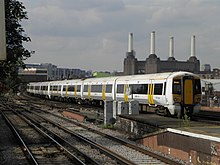
Pasażerskie połączenia kolejowe na terenie Lambeth obsługują przewoźnicy Southern, Southeastern, South West Trains oraz First Capital Connect.
Stacje kolejowe:
- Brixton
- Clapham High Street
- Gipsy Hill – na granicy z Southwark
- Herne Hill
- Loughborough Junction
- Streatham
- Streatham Common
- Streatham Hill
- Tulse Hill
- Vauxhall
- Wandsworth Road
- Waterloo
- Waterloo East
- West Norwood
Mosty:
Tramwaje wodne - Thames Clippers[11]
Przystanie:
- London Eye Millenium Pier
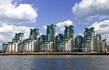
- St George Wharf Pier
Miejsca i muzea

- London Eye
- London County Hall – siedziba Dalí Universe, Sea Life London Aquarium i London Film Museum[12]
- Pałac Lambeth
- Florence Nightingale Museum[13] które znajduje się w Szpitalu św. Tomasza w Londynie
- Museum of Garden History[14]
- Royal National Theatre[15]
- Southbank Centre (największe centrum kultury i sztuki w Europie) w skład którego wchodzą:
- Royal Festival Hall[16] - Queen Elizabeth Hall[17] - Hayward Gallery[18] - Purcell Room[19]
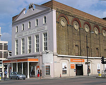
- The Old Vic Theatre[20]
- The Type Museum[21]
- South London Theatre[22]
- Bicha Gallery[23]
- The Oval (The Kia Oval) – stadion do krykieta na 23500 widzów, siedziba jednego z 18 profesjonalnych klubów krykietowych Surrey County Cricket Club[24]
- Brixton murals - wielkoformatowa grafika na ścianach budynków tzw. Mural[25]
- O2 Academy Brixton – jedno z wiodących miejsc w Londynie słynących z muzycznych przedstawień itp[26]
- siedziba MI6 (Secret Intelligence Service)
Edukacja
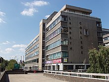
- Lambeth College[27]
- London Waterloo - Law School[28]
- London Waterloo Academy[29]
- South Chelsea College[30]
- Morley College[31]
- Marine Society College of the Sea[32]
- City & Guilds of London Art School[33]
Znane osoby
W Lambeth urodzili się m.in.
- David Bowie – piosenkarz
- Margaret Rutherford – aktorka
- Scott Parker – piłkarz
- Carl McCoy – muzyk
- Naomi Campbell – modelka
- Ken Livingstone – były burmistrz Londynu
- Arthur Sullivan – kompozytor
- John Nash – architekt
- Naveen Andrews – aktor
- Basement Jaxx – duet muzyków
- Roger Moore - aktor
- Deborah Dyer – wokalistka
- Paul Simonon – muzyk z The Clash
- Mick Jones – muzyk z The Clash
- Lytton Strachey – krytyk i pisarz
- Patrick Wolf – muzyk
- Elly Jackson – muzyk z La Roux
- Roddy McDowall – aktor
- John Newlands – chemik
- Bernard Law Montgomery – dowódca wojskowy
- Simon Callow – aktor
- Peter Davison – aktor
- Nicholas Clay – aktor
- Des’ree – wokalistka
- Maxi Jazz – wokalista z Faithless
Przypisy
- ↑ Population Estimates for UK, England and Wales, Scotland and Northern Ireland - Office for National Statistics, ons.gov.uk [dostęp 2017-10-16] (ang.).
- ↑ „London postcodes”. [dostęp 2011-10-09]. [zarchiwizowane z tego adresu (2006-11-04)].
- ↑ „ Legislation.gov.uk- London Government Act 1963”
- ↑ „ hansard.millbanksystems.com-London Government Act 1899”
- ↑ „Lambeth Map of Wards – Lambeth Council”. [dostęp 2012-08-03]. [zarchiwizowane z tego adresu (2012-08-03)].
- ↑ „ukpollingreport.co.uk - Dulwich adn Westnorwood”
- ↑ „ons.gov.uk – 2011 Census: KS102EW Age structure, local authorities in England and Wales”
- ↑ „ons.gov.uk – 2011 Census: KS201EW Ethnic group, local authorities in England and Wales”
- ↑ „ons.gov.uk – 2011 Census: KS209EW Religion, local authorities in England and Wales”
- ↑ „ons.gov.uk – 2011 Census: KS204EW Country of birth, local authorities in England and Wales”
- ↑ „Thames Clippers”
- ↑ „londonfilmmuseum.com - London Film Museum”
- ↑ „florence-nightingale.co.uk - Florence Nightingale Museum”
- ↑ „gardenmuseum.org.uk - Garden Museum”. [dostęp 2011-10-02]. [zarchiwizowane z tego adresu (2011-10-23)].
- ↑ „nationaltheatre.org.uk - National Theatre”
- ↑ „Southbank Centre – Royal Festival Hall ”. [dostęp 2011-10-02]. [zarchiwizowane z tego adresu (2011-10-05)].
- ↑ „Southbank Centre – Queen Elizabeth Hall ”. [dostęp 2011-10-02]. [zarchiwizowane z tego adresu (2011-10-07)].
- ↑ „Southbank Centre – Hayward Gallery”. [dostęp 2011-10-02]. [zarchiwizowane z tego adresu (2011-10-01)].
- ↑ „Southbank Centre – Purcell Room”. [dostęp 2011-10-02]. [zarchiwizowane z tego adresu (2011-09-23)].
- ↑ „oldvictheatre.com - Old Vic Theatre”
- ↑ „typemuseum.org - Type Museum”. [dostęp 2011-11-19]. [zarchiwizowane z tego adresu (2009-02-20)].
- ↑ „southlondontheatre.co.uk - South London Theatre”. [dostęp 2011-11-19]. [zarchiwizowane z tego adresu (2011-11-15)].
- ↑ „secure.bicha.co.uk - Bicha Gallery”. [dostęp 2011-11-19]. [zarchiwizowane z tego adresu (2011-04-18)].
- ↑ „Offical site Surrey County Cricket”
- ↑ „flickr (tagged „brixtonmurals”
- ↑ „o2academybrixton.co.uk - o2 Academy Brixton”
- ↑ „lambethcollege.ac.uk - Lambeth College”
- ↑ „bpp.com - London Waterloo - Law School”
- ↑ „waterlooacademy.co.uk - London Waterloo Academy”
- ↑ „southchelseacollege.co.uk - South Chelsea College”
- ↑ „morleycollege.ac.uk - Morley College”
- ↑ „ms-sc.org - Marine Society College of the Sea”
- ↑ „cityandguildsartschool.ac.uk - City & Guilds of London Art School”. [dostęp 2011-11-19]. [zarchiwizowane z tego adresu (2009-01-31)].
Media użyte na tej stronie
Flag of England. Saint George's cross (a red cross on a white background), used as the Flag of England, the Italian city of Genoa and various other places.
Flag of Jamaica. “The sunshine, the land is green, and the people are strong and bold” is the symbolism of the colours of the flag. GOLD represents the natural wealth and beauty of sunlight; GREEN represents hope and agricultural resources; BLACK represents the strength and creativity of the people. The original symbolism, however, was "Hardships there are, but the land is green, and the sun shineth", where BLACK represented the hardships being faced.
Flag of Portugal, created by Columbano Bordalo Pinheiro (1857-1929), officially adopted by Portuguese government in June 30th 1911 (in use since about November 1910). Color shades matching the RGB values officially reccomended here. (PMS values should be used for direct ink or textile; CMYK for 4-color offset printing on paper; this is an image for screen display, RGB should be used.)
The flag of Navassa Island is simply the United States flag. It does not have a "local" flag or "unofficial" flag; it is an uninhabited island. The version with a profile view was based on Flags of the World and as a fictional design has no status warranting a place on any Wiki. It was made up by a random person with no connection to the island, it has never flown on the island, and it has never received any sort of recognition or validation by any authority. The person quoted on that page has no authority to bestow a flag, "unofficial" or otherwise, on the island.
The Flag of India. The colours are saffron, white and green. The navy blue wheel in the center of the flag has a diameter approximately the width of the white band and is called Ashoka's Dharma Chakra, with 24 spokes (after Ashoka, the Great). Each spoke depicts one hour of the day, portraying the prevalence of righteousness all 24 hours of it.
Autor: Pedro A. Gracia Fajardo, escudo de Manual de Imagen Institucional de la Administración General del Estado, Licencja: CC0
Flaga Hiszpanii
(c) Photograph by Mike Peel (www.mikepeel.net). Adjustments by Lycaon., CC BY-SA 4.0
The London Eye in London, England. I believe that the bright dot in the sky is the planet Mars.
Edits made to original image: adjustment of highlight levels (also present in the other version) and noise filtered with Neat Image and added another of the author's images to create a panorama. (by Lycaon)
Autor: Caroline Ford, Licencja: CC-BY-SA-3.0
Old Vic theatre, London Waterloo
Autor: Sunil060902, Licencja: CC BY-SA 3.0
Southeastern Class 375 unit 375803 leads an 8-car train past Wandsworth Road station with a service from London Victoria. Battersea Power Station can be seen in the background.
(c) Stuart Taylor, CC BY-SA 2.0
Brixton Town Hall, London. The foundation stone was laid on the 21st July 1906, and the building was officially opened by King George V and Queen Mary (then Prince and Princess of Wales) on the 29th April, 1908.
Autor: Sunil060902, Licencja: CC BY-SA 3.0
Main entrance to London Waterloo railway station, on the north-east side
Autor: David Samuel, User:Hellodavey1902, Licencja: CC BY-SA 3.0
Photograph of the Royal National Theatre, London, England. Nikon D40X 18-135mm lens.
Autor: Sirje S, Licencja: CC BY 2.0
St George’s Wharf, Vauxhall, South London. Architects: Broadway Malyan Architects
Autor: Oryginalnym przesyłającym był Mnbf9rca z angielskiej Wikipedii, Licencja: CC BY-SA 2.5
Taken by me, 2003-01-28. Attribute to "Robert Aleck, www.cynexia.com"
Autor: Image:LondonLambeth.png by Morwen, Image:BlankMap-LondonBoroughs.svg by Richtom80, Licencja: CC BY 2.5
Locator map of the London Borough of Lambeth, shown (in red) within Greater London.
Autor: Iridescent, Licencja: CC BY-SA 3.0
Waterloo Bridge, London. Photograph taken in a public location in the UK of a building on permanent public display, and exempt from copyright under Section 62 of the Copyright Designs & Patents Act 1988 ("it is not an infringement of copyright to film, photograph, broadcast or make a graphic image of a building, sculpture, models for buildings or work of artistic craftsmanship if that work is permanently situated in a public place or in premises open to the public")
(c) David Hawgood, CC BY-SA 2.0
Lambeth College. Taken from Wandsworth Road looking along the frontage to Belmore Street


