London Borough of Southwark
| London Borough of | |
 Ratusz w Londynie | |
| Państwo | |
|---|---|
| Kraj | |
| Region | Wielki Londyn |
| Burmistrz | Charlie Smith |
| Powierzchnia | 28,85 km² |
| Populacja (2016) • liczba ludności | 313 223[1] |
| • gęstość | 10 857 os./km² |
| Kod pocztowy | SE1, SE4, SE5, SE8, SE11, SE14, SE15, SE16, SE17, SE19, SE21, SE22, SE23, SE24, SE26[2] |
Położenie na mapie Wielkiego Londynu | |
| Strona internetowa | |
| Portal | |

London Borough of Southwark – jedna z 32 gmin Wielkiego Londynu położona w jego południowo - wschodniej części. Wraz z 11 innymi gminami wchodzi w skład tzw. Londynu Wewnętrznego. Władzę stanowi Rada Gminy Southwark (ang. Southwark London Borough Council).
Historia
Gminę utworzono w 1965 na podstawie ustawy London Government Act 1963[3] ze stołecznych gmin Southwark (ang. Metropolitan Borough of Southwark), Camberwell (ang. Metropolitan Borough of Camberwell) i Bermondsey (ang. Metropolitan Borough of Bermondsey), które utworzono w 1900 roku w ramach podziału hrabstwa County of London na 28 gmin[4].
Geografia
Gmina Southwark ma powierzchnię 28,85 km2, graniczy od wschodu z Lewisham, od południa z Bromley i w obrębie jednego skrzyżowania z Croydon, od zachodu z Lambeth, zaś od północy przez Tamizę z City of London i Tower Hamlets.
W skład gminy Southwark wchodzą następujące obszary:
|
|
Gmina dzieli się na 21 okręgów wyborczych[5] które nie pokrywają się dokładnie z podziałem na obszary, zaś mieszczą się w 3 rejonach tzw. borough constituencies - Bermondsey and Old Southwark, Camberwell and Peckham i Dulwich and West Norwood[6].
|
|
Demografia
W 2011 roku gmina Southwark miała 288 283 mieszkańców[7].
Podział mieszkańców według grup etnicznych na podstawie spisu powszechnego z 2011 roku[8]:
|
|
Podział mieszkańców według wyznania na podstawie spisu powszechnego z 2011 roku[9]:
- Chrześcijaństwo - 52,5%
- Islam – 8,5%
- Hinduizm – 1,3%
- Judaizm – 0,3%
- Buddyzm – 1,3%
- Sikhizm – 0,2%
- Pozostałe religie – 0,5%
- Bez religii – 26,7%
- Nie podana religia – 8,5%
Podział mieszkańców według miejsca urodzenia na podstawie spisu powszechnego z 2011 roku[10]:
|
|
Transport
Przez dzielnicę Southwark przebiegają trzy linie metra: Bakerloo Line, Jubilee Line i Northern Line.
Stacje metra:
- Bermondsey - Jubilee Line
- Borough - Jubilee Line
- Canada Water - Jubilee Line
- Elephant&Castle - Bakerloo Line
- Kennington - Northern Line (na granicy z Lambeth)
- London Bridge - Jubilee Line i Northern Line
Pasażerskie połączenia kolejowe na terenie Southwark obsługują przewoźnicy Southern, Southeastern, London Overground oraz First Capital Connect.
Stacje kolejowe:
- Denmark Hill
- East Dulwich
- Elephant & Castle
- Gipsy Hill
- Honor Oak Park (na granicy z Lewisham)
- London Bridge
- North Dulwich
- Nunhead
- Peckham Rye
- Queens Road Peckham
- South Bermondsey
- Sydenham Hill
- West Dulwich
Stacje London Overground:
Mosty i tunele:
- Blackfriars Bridge
- London Bridge
- Millennium Bridge
- Southwark Bridge
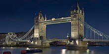
- Tower Bridge
- Rotherhithe Tunnel
Tramwaje wodne - Thames Clippers[11]
Przystanie:
- Bankside Pier
- Greenland Pier
- Hilton Docklands Nelson Dock Pier
- London Bridge City Pier
Miejsca i muzea

- Tower Bridge
- Millennium Bridge
- City Hall
- Shakespeare's Globe
- Tate Modern
- Shard London Bridge
- Imperial War Museum
- HMS Belfast
- Golden Hind
- Dulwich Picture Gallery[12]
- London Fire Brigade Museum[13]
- The Clink Prison Museum[14]
- Old Operating Theatre Museum[15]
- Fashion & Textile Museum[16]
- Rotherhithe Heritage Museum[17]
- Brunel Museum[18]
- Unicorn Theatre For Children[19]
- National Youth Theatre Of Great Britain[20]
- Blue Elephant Theatre[21]
- South London Gallery[22]
- Bankside Gallery[23]
- Purdy Hicks Gallery[24]
- London Glassblowing Studio and Gallery[25]
- Hay's Galleria
- założony w 1894 roku Dulwich and Sydenham Hill Golf Club[26]
- Herne Hill Velodrome[27]
Edukacja
W dzielnicy Southwark znajdują się:
- London South Bank University (LSBU) w Elephant and Castle na którym obecnie kształci się około 25000 studentów[28]
- dwa wydziały University of the Arts London[29]: The London College of Communication w Elephant and Castle a Camberwell College of Arts na Peckham Road
- wchodzące w skład jednego z najwyżej ocenianych uniwersytetów na świecie King’s College:
- British Universities & Colleges Sport (BUCS)[34]
- City of London Academy (Southwark)[35]
- Southwark College[36]
- Kaplan Law School[37]
- London School of Commerce[38]
- London Bridge Business Academy[39]
- London Community College[40]
- Harris Academy at Peckham[41]
- St Saviour's and St Olave's Church of England School[42]
- Walworth Academy[43]
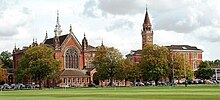
- Dulwich College[44]
- Alleyn's School[45]
Znane osoby
W Southwark urodzili się m.in.
- Michael Caine - aktor
- Charlie Chaplin - aktor i reżyser
- Boris Karloff - aktor
- Tim Roth - aktor i reżyser
- John Harvard - pastor
- Robert Browning - poeta i dramatopisarz
- Michael Faraday - fizyk i chemik
- Anthony James Leggett - fizyk
- Rio Ferdinand - piłkarz
Przypisy
- ↑ Population Estimates for UK, England and Wales, Scotland and Northern Ireland - Office for National Statistics, www.ons.gov.uk [dostęp 2017-10-16] (ang.).
- ↑ „London postcodes”. [dostęp 2011-10-09]. [zarchiwizowane z tego adresu (2006-11-04)].
- ↑ „ Legislation.gov.uk- London Government Act 1963”
- ↑ „ hansard.millbanksystems.com-London Government Act 1899”
- ↑ „southwark.gov.uk - Your Councillors by Ward”
- ↑ „ukpollingreport.co.uk - London”
- ↑ „ons.gov.uk – 2011 Census: KS102EW Age structure, local authorities in England and Wales”
- ↑ „ons.gov.uk – 2011 Census: KS201EW Ethnic group, local authorities in England and Wales”
- ↑ „ons.gov.uk – 2011 Census: KS209EW Religion, local authorities in England and Wales”
- ↑ „ons.gov.uk – 2011 Census: KS204EW Country of birth, local authorities in England and Wales”
- ↑ „Thames Clippers”
- ↑ „dulwichpicturegallery.org.uk - Dulwich Picture Gallery”
- ↑ „london-fire.gov.uk - London Fire Brigade Museum”. [dostęp 2011-09-30]. [zarchiwizowane z tego adresu (2011-09-28)].
- ↑ „clink.co.uk - The Cling Prison Museum”
- ↑ „thegarret.org.uk - Old Operating Theatre Museum”. [dostęp 2011-11-19]. [zarchiwizowane z tego adresu (2011-11-26)].
- ↑ „ftmlondon.org - Fashion & Textile Museum”
- ↑ „thepumphouse.org.uk - Rotherhithe Heritage Museum”
- ↑ „brunel-museum.org.uk - Brunel Museum”
- ↑ „unicorntheatre.com - Unicorn Theatre For Children”
- ↑ „nyt.org.uk - National Youth Theatre Of Great Britain”
- ↑ „blueelephanttheatre.co.uk - Blue Elephant Theatre”
- ↑ „southlondongallery.org - South London Gallery”
- ↑ „banksidegallery.com - Bankside Gallery”
- ↑ „purdyhicks.com - Purdy Hicks Gallery”
- ↑ „londonglassblowing.co.uk - London Glassblowing Studio and Gallery”
- ↑ „dulwichgolf.co.uk - Dulwich and Sydenham Hill Golf Club ”
- ↑ „hernehillvelodrome.com - Herne Hill Velodrome”
- ↑ „lsbu.ac.uk - London South Bank University ”
- ↑ „arts.ac.uk - University of the Arts London”
- ↑ „kcl.ac.uk - Randall Division of Cell & Molecular Biophysics”
- ↑ „kcla.ac.uk - Institute Of Psychiatry”
- ↑ „kcla.ac.uk - School of Medicine”
- ↑ „kcl.ac.uk - Dental Institute”
- ↑ „bucs.org.uk - British Universities & Colleges Sport”. [dostęp 2011-11-19]. [zarchiwizowane z tego adresu (2011-11-22)].
- ↑ „cityacademy.co.uk - City of London Academy (Southwark)”
- ↑ „southwark.ac.uk - Southwark College”
- ↑ „kaplan-law-school.kaplan.co.uk - Kaplan Law School”
- ↑ „lsclondon.co.uk - London School of Commerce”
- ↑ „lbbaglobal.com - London Bridge Business Academy”
- ↑ „londoncommunitycollege.co.uk - London Community College”
- ↑ „harrispeckham.org.uk - Harris Academy at Peckham”
- ↑ „southwark.sch.uk - St Saviour's and St Olave's Church of England School”
- ↑ „walworthacademy.org - Walworth Academy”
- ↑ „dulwich.org.uk - Dulwich College”
- ↑ „alleyns.org.uk - Alleyn's School”
Media użyte na tej stronie
Flag of England. Saint George's cross (a red cross on a white background), used as the Flag of England, the Italian city of Genoa and various other places.
Flag of Jamaica. “The sunshine, the land is green, and the people are strong and bold” is the symbolism of the colours of the flag. GOLD represents the natural wealth and beauty of sunlight; GREEN represents hope and agricultural resources; BLACK represents the strength and creativity of the people. The original symbolism, however, was "Hardships there are, but the land is green, and the sun shineth", where BLACK represented the hardships being faced.
The Flag of India. The colours are saffron, white and green. The navy blue wheel in the center of the flag has a diameter approximately the width of the white band and is called Ashoka's Dharma Chakra, with 24 spokes (after Ashoka, the Great). Each spoke depicts one hour of the day, portraying the prevalence of righteousness all 24 hours of it.
The flag of Navassa Island is simply the United States flag. It does not have a "local" flag or "unofficial" flag; it is an uninhabited island. The version with a profile view was based on Flags of the World and as a fictional design has no status warranting a place on any Wiki. It was made up by a random person with no connection to the island, it has never flown on the island, and it has never received any sort of recognition or validation by any authority. The person quoted on that page has no authority to bestow a flag, "unofficial" or otherwise, on the island.
Autor: Pedro A. Gracia Fajardo, escudo de Manual de Imagen Institucional de la Administración General del Estado, Licencja: CC0
Flaga Hiszpanii
Flag of Portugal, created by Columbano Bordalo Pinheiro (1857-1929), officially adopted by Portuguese government in June 30th 1911 (in use since about November 1910). Color shades matching the RGB values officially reccomended here. (PMS values should be used for direct ink or textile; CMYK for 4-color offset printing on paper; this is an image for screen display, RGB should be used.)
Autor: Tohma, Licencja: CC BY-SA 4.0
Innenraum des Globe Theatre in London
(c) Noel Foster, CC BY-SA 2.0
Dulwich College, College Road, Dulwich. West side of the oldest buildings, viewed from Alleyn Park.
Autor: Cristian Bortes from Cluj-Napoca, Romania, Licencja: CC BY 2.0
April 2012
Autor: Oosoom, Licencja: CC BY-SA 3.0
Sculpture: The Navigators 1987 by David Kemp in Hay's Galleria (formerly Hay's Wharf), London, England.
Autor: Image:LondonSouthwark.png by Morwen, Image:BlankMap-LondonBoroughs.svg by Richtom80, Licencja: CC BY 2.5
Locator map of the London Borough of Southwark, shown (in red) within Greater London.
Areas of Southwark
Autor: IxK85, Licencja: CC BY-SA 3.0
A view of the atrium of the Imperial War Museum in London.
(c) Nigel Chadwick, CC BY-SA 2.0
The Shard rising above London Bridge Station, near to Bermondsey, Southwark, Great Britain.
A 72-storey office building / hotel, being constructed from 2009-2012 as the centre of the London Bridge Quarter development on the South bank of the Thames. When completed, the skyscraper will, at 310m tall, be for a while the tallest building in the UK and possibly in the world (depending on other developments elsewhere).
The official website is <a title="http://www.shardlondonbridge.com" rel="nofollow" href="http://www.shardlondonbridge.com">Link</a><img style="padding-left:2px;" alt="External link" title="External link - shift click to open in new window" src="http://s0.geograph.org.uk/img/external.png" width="10" height="10"/>
See also the Wikipedia entry at <a title="http://en.wikipedia.org/wiki/Shard_London_Bridge" rel="nofollow" href="http://en.wikipedia.org/wiki/Shard_London_Bridge">Link</a><img style="padding-left:2px;" alt="External link" title="External link - shift click to open in new window" src="http://s0.geograph.org.uk/img/external.png" width="10" height="10"/>
Autor: Peterlebato, Licencja: CC BY 3.0
HDR view from Tower Bridge, uk
Autor: Diliff, Licencja: CC BY-SA 3.0
An extremely high resolution image of Tower Bridge in London. This image is a mosaic of 53 12.8 megapixel segments stitched with PTGui. They were taken with a Canon 5D and 70-200mm f/2.8L at ~185mm, f14 and 3.2 seconds per exposure.
HMS Belfast, London
Autor: Oryginalnym przesyłającym był Secretlondon z angielskiej Wikipedii, Licencja: CC-BY-SA-3.0
London Southbank University taken on 29th Feb 04 by C Ford.


