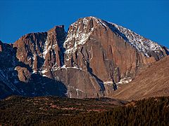
Longs Peak
| ||
Longs Peak | ||
| Państwo | ||
| Stan | ||
| Położenie | Kolorado | |
| Pasmo | Góry Skaliste | |
| Wysokość | 4346 m n.p.m. | |
| Wybitność | 2994 m | |
| Pierwsze wejście | 1868 John Wesley Powell | |
Longs Peak (dawniej Long's Peak) – szczyt Gór Skalistych, w paśmie Front Range. Leży na terenie Parku Narodowego Gór Skalistych, którego jest najwyższym punktem. Nazwany został na cześć Stephena Longa, odkrywcy badającego rejon szczytu w latach 20' XIX wieku. Longs Peak oraz pobliski Mount Meeker, nazywane są czasami Twin Peaks (pol. Bliźniacze Szczyty).
Pierwszego odnotowanego wejścia na szczyt dokonał John Wesley Powell w 1868 r. Bardzo prawdopodobne jest jednak, że przed nim na szczyt został zdobyty przez miejscowych Indian, którzy zbierali tu orle pióra.
Bibliografia
Media użyte na tej stronie
The flag of Navassa Island is simply the United States flag. It does not have a "local" flag or "unofficial" flag; it is an uninhabited island. The version with a profile view was based on Flags of the World and as a fictional design has no status warranting a place on any Wiki. It was made up by a random person with no connection to the island, it has never flown on the island, and it has never received any sort of recognition or validation by any authority. The person quoted on that page has no authority to bestow a flag, "unofficial" or otherwise, on the island.
Black up-pointing triangle ▲, U+25B2 from Unicode-Block Geometric Shapes (25A0–25FF)
Autor: NordNordWest, Licencja: CC BY 3.0
Location map of Colorado, USA
(c) ProfPete at the English Wikipedia, CC-BY-SA-3.0
East face of Longs Peak, including The Diamond, showing multiple climbing routes.
Autor: Uwe Dedering, Licencja: CC BY-SA 3.0
Relief location map of the USA (without Hawaii and Alaska).
EquiDistantConicProjection : Central parallel :
* N: 37.0° N
Central meridian :
* E: 96.0° W
Standard parallels:
* 1: 32.0° N
* 2: 42.0° N
Made with Natural Earth. Free vector and raster map data @ naturalearthdata.com.
Formulas for x and y:
x = 50.0 + 124.03149777329222 * ((1.9694462586094064-({{{2}}}* pi / 180))
      * sin(0.6010514667026994 * ({{{3}}} + 96) * pi / 180))
y = 50.0 + 1.6155950752393982 * 124.03149777329222 * 0.02613325650382181
      - 1.6155950752393982  * 124.03149777329222 *
     (1.3236744353715044  - (1.9694462586094064-({{{2}}}* pi / 180))
      * cos(0.6010514667026994 * ({{{3}}} + 96) * pi / 180))


