Longuyon
| miejscowość i gmina | |||
 | |||
| |||
| Państwo | |||
|---|---|---|---|
| Region | |||
| Departament | |||
| Okręg | |||
| Kod INSEE | 54322 | ||
| Powierzchnia | 29,73 km² | ||
| Populacja (1990) • liczba ludności |
| ||
| • gęstość | 204 os./km² | ||
| Kod pocztowy | 54260 | ||
| Portal | |||
Longuyon – miejscowość i gmina we Francji, w regionie Grand Est, w departamencie Meurthe i Mozela.
Według danych na rok 1990 gminę zamieszkiwały 6064 osoby, a gęstość zaludnienia wynosiła 204 osób/km² (wśród 2335 gmin Lotaryngii Longuyon plasuje się na 72. miejscu pod względem liczby ludności, natomiast pod względem powierzchni na miejscu 63.).
Populacja
Współpraca
 Pirna, Niemcy
 Tizi Rached, Algieria
 Żary, Polska
 Limana, Włochy
 Schmitshausen, Niemcy
 Walferdange, Luksemburg
Bibliografia
- Francuski urząd statystyczny (fr.).
Media użyte na tej stronie
Autor: Flappiefh, Licencja: CC BY-SA 4.0
Blank administrative map of the department of Meurthe-et-Moselle, France, for geo-location purpose.
Autor: Superbenjamin, Licencja: CC BY-SA 4.0
Blank administrative map of France for geo-location purpose, with regions and departements distinguished. Approximate scale : 1:3,000,000
Autor: Flappiefh, Licencja: CC BY-SA 4.0
Carte administrative vierge de la région Grand Est, France, destinée à la géolocalisation.
Autor: Michiel1972, Licencja: CC BY-SA 3.0
Population - Municipality code 54322.svg
Population Census 1962-2008Autor: John Dalton at en Wikipedia, Licencja: CC-BY-SA-3.0
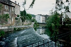
The Crusnes river in Longuyon, France


