Los Angeles Westside
| Kalifornia | |
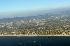
Zdjęcie lotnicze obszaru Westside | |
| Państwo | |
|---|---|
| Stan | |
| Powierzchnia | 262 km² |
| Populacja (2000) • liczba ludności |
|
| • gęstość | 2018 os./km² |
| Szczegółowy podział administracyjny | |
| Liczba miast | 4 |
| Liczba obszarów niemunicypalnych | 2 |
| Liczba dzielnic | 24 |
Położenie na mapie Los Angeles | |
| 34°03′41,51″N 118°27′12,21″W/34,061531 -118,453392 | |
| Portal | |
Los Angeles Westside – zurbanizowany region położony w zachodniej części hrabstwa Los Angeles w Kalifornii. Obszar ten nie jest zdefiniowany oficjalnie, lecz zgodnie z projektem gazety Los Angeles Times – "Mapping L.A."[1] zajmuje powierzchnię 262 km², obejmując swoim zasięgiem nie tylko dzielnice miasta Los Angeles, ale również dwa obszary niemunicypalne oraz cztery miasta.
Gminy i dystrykty
Miasta
Obszary niemunicypalne
- Marina del Rey
- Veterans Administration
Dzielnice
- Bel Air
- Beverly Crest
- Beverly Grove
- Beverlywood
- Brentwood
- Century City
- Cheviot Hills
- Crestview
- Del Rey
- Fairfax District
- Ladera Heights
- Mar Vista
- Mid-Wilshire
- Pacific Palisades
- Palms
- South Robertson
- Playa del Rey
- Playa Vista
- Rancho Park
- Sawtelle
- Venice
- West Los Angeles
- Westchester
- Westwood
Bibliografia
Przypisy
- ↑ Mapping L.A. - The Westside (ang.). [dostęp 2015-11-06].
Media użyte na tej stronie
The flag of Navassa Island is simply the United States flag. It does not have a "local" flag or "unofficial" flag; it is an uninhabited island. The version with a profile view was based on Flags of the World and as a fictional design has no status warranting a place on any Wiki. It was made up by a random person with no connection to the island, it has never flown on the island, and it has never received any sort of recognition or validation by any authority. The person quoted on that page has no authority to bestow a flag, "unofficial" or otherwise, on the island.
Flag of California. This version is designed to accurately depict the standard print of the bear as well as adhere to the official flag code regarding the size, position and proportion of the bear, the colors of the flag, and the position and size of the star.
(c) Coolcaesar z angielskojęzycznej Wikipedii, CC-BY-SA-3.0
The Westside of the Los Angeles area, as photographed from a flight departing Los Angeles International Airport on August 10, 2006. Photographed and uploaded by user Coolcaesar
3-D Perspective image of the Los Angeles Basin from the Landsat satellite using NASA's Shuttle Radar Topography Mission (SRTM) for topography information. The vertical scale is exaggerated one and half times.
Autor: Los Angeles Times, Licencja: CC BY-SA 2.0
Map of the Westside area of Los Angeles County, Califorrnia, to be used in Westside (Los Angeles County)
Autor: Cookaa, Licencja: CC BY-SA 3.0
irgendwas ist an diesem Strand immer los


